
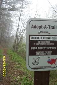
Cherokee Hiking Club
198 Crews Drive, Benton, TN 37307
![]()
Benton MacKaye Trail
Trail Maintenance
Benton
MacKaye Trail - Section 13
John Muir Trail to Coker Creek
John Muir Trail Reroute
FINAL
DATA AND MAPS
MAP of reroute
Profile of reroute
The John Muir Trail is a beautiful trail along the south edge of the Hiwassee River Gorge in eastern Tennessee which runs for 19 miles from the Childers Creek Trailhead near Reliance to about 3 miles east of TN68. This was the route Desoto took through Tennessee as well as John Muir on one of his travels. The first 6 miles follows the river closely from the powerhouse downstream. River levels range from almost dry to a raging torrent when electricity is being generated, creating a playground for kayakers. When the powerhouse is not generating, the trout fishermen are wading out into the riverbed going after that big one. Above the powerhouse, the old riverbed is nearly dry most of the time, only being fed by the creeks entering the river below the Appalachia Dam. Major creek crossings are Towee Creek, Loos Creek and Coker Creek. A side trail up Coker Creek leads to the spectacular Coker Creek Falls. Several good campsites are along the route of the JMT. This trail is also part of the Benton MacKaye Trail, a 300 mile long distance trail from Springer Mountain, GA to the north end of the Smokies. On the south bank of the Hiwassee River runs the old L&N Railroad which used to be the main route from east Tennessee to Atlanta. The track now carries tourists up the gorge from near Etowah, TN, to Blue Ridge, GA. The train ride goes through the corkscrew double loop to get riders up out of the gorge.
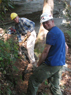
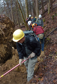
Ken Jones, Clayton Pannel and Rick Harris made a start at logging out and brushing out the new reroute today. They went in from the Towee Creek overflow parking, and began work right away. Ken and Clayton cleared all of the trees to Towee Creek, up the old road bed to the switchback, along the steep side hill to the top of the ridge, and then almost all of the next sidehill that ends in a gap before the trail makes the final sidehill climb to the high ridge line. There were a lot of dead pines down on this last sidehill segment. Ken burned three tanks of gas in his saw. Rick Harris worked behind us on brushing out the route. He started at the parking area, and worked to a spot about 100 yards beyond the Towee Creek crossing.
Name
Travel Hours
Work Hours
Totals
Ken Jones
1
7
8
Clayton Pannell
1
7
8
Rick Harris
2
7.5
9.5
Totals
4
21.5
25.5
Wednesday, May 14, 2008: We continued working on the reroute today with a start on side hill tread
construction. We went in across Towee Creek and began our work at the switchback at the end of the old road. We had to install cribbing along several sections of the trail due to the steep side slope. Clayton got to chop out an 8” hemlock root that we just could not find a way around for the tread. For the day we completed about 160’ of new side hill tread and also completed the one and only switchback on the side slope.
This new segment should give us a good example to show new workers at National Trails Day. We also decided that our next work day should be cutting and installing cribbing for the National Trails Day event. The cribbing will make the steep side hill construction easier, and will ensure that the tread is built exactly where we want it.
Here are our volunteer hours for the work trip:
Name
Travel Hours
Work Hours
Totals
Ken Jones
2
6.5
8.5
Clayton Pannell
2
6.5
8.5
Totals
4
13
17
Wednesday, May 21, 1008: We continued working on the reroute today, doing mostly what would be called National Trails Day (NTD) preparation work. We installed some additional cribbing in a number of places on the first steep side hill segment going in from Towee Creek. This will help ensure that the trail gets dug in where we want it on NTD. We have several additional places that still need cribbing. We have cut the cribbing, but it was too big for us to drag uphill to the spots. We left it in place for when we have some more manpower to drag it back up the hill. There was one new tree (10”) down across the flag line that came down since last Wednesday. We also cleared the flag line up to the ridge, along the top of the ridge, and maybe 100 yards of the second side hill segment. We cleared the path so that anyone working on NTD will be able to find the correct place for the trail and see the flags without our assistance.
Here is our volunteer time for the trip:
Name
Travel Hours
Work Hours
Totals
Ken Jones
1.5
7
8.5
Rick Harris
2.5
7
9.5
Totals
4
14
18
Wednesday, May 28, 1008: We continued work today on logging out and brushing out the reroute. Clayton started brushing out with the weed eater at the top of the first ridge line on the flat area. I picked up
with the chainsaw where I had left off on the second side slope segment. It started to rain about 11 am, and by lunch time we were wet. We decided to call it a day after lunch since it was no longer safe to run the power tools on the steep side slope. I believe that we each completed about ¼ mile of additional work. Next Wednesday we plan to install some more cribbing on the first side slope segment and possibly do some more digging.
Here is our time for the day:
Name
Travel Hours
Work Hours
Totals
Ken Jones
1
4
5
Clayton Pannell
1
4
5
Totals
2
8
10
Wednesday, June 4, 1008: We spent today doing more preparation for National Trails Day. We went in across Towee Creek to the
first steep side hill section just after the switchback off the old road bed. We spent the day cutting logs and stakes for cribbing, and then installing them in all of the places that they were needed. We did a little digging in the hard spots, grubbing out some stumps. We should be ready for the large digging crew to attack the slope this coming Saturday. It was very hot working today, so we need to keep a careful watch on the work crew for Saturday.
Here is our time for the day:
Name
Travel Hours
Work Hours
Totals
Ken Jones
1.5
6
7.5
Clayton Pannell
1.5
6
7.5
Rick Harris
2
6
8
Totals
5
18
23
Saturday, June 7, 2008: Come join us in celebrating National Trails Day with a work trip on the John Muir Trail / Benton
MacKaye Trail. We will be working on constructing a new trail segment that fixes several long standing problem areas on the existing trail. The work will consist of digging in the dirt with pulaskis and mattocks in an area close to Towee Creek and the Hiwassee River. This event is sponsored by the Ocoee / Hiwassee Ranger District of the Cherokee National Forest, Hiwassee Hiking Club, Cherokee Hiking Club, Chattanooga Hiking Club, and the Benton MacKaye Trail Association. Tools and safety gear will be provided, but remember to bring plenty of food and water. T-shirts will be awarded to the first 24 participants, and there will be other door prizes available to everyone who helps make this event a success. Meet at the intersection of US 411 and Hwy 30 in the vacant lot across from the store at 9 AM. For additional information, contact Ken Jones at 745-2451 or mkjones@comcast.net.
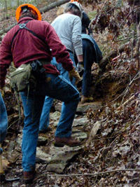
We had a great National Trails Day event with 29 workers helping build a much needed reroute of the John Muir / Benton MacKaye Trail. We had participants from all four of the sponsoring clubs (Benton MacKaye Trail Association, Chattanooga Hiking Club, Cherokee Hiking Club, and Hiwassee Hiking Club) as well as 5 guests. We started the events of the day with sign-in, awarding T-shirts and door prizes, and a tailgate safety briefing. Worker safety was an especially important consideration since the temperatures hit the mid 90s for the day. With the large number of workers, we split into 3 crews that worked on different tasks and sections of the reroute. One crew worked on brushing out an old road bed, while there were two digging crews working on different side hill segments to constuct new tread.
The brush out crew finished cleaning out all of the old road bed (0.15 miles). The lower digging crew finished about 420’ of new tread construction, while the smaller in numbers upper digging crew completed 300’ of new tread for the day. The day was a wonderful success, with all of the workers performing great in some really difficult conditions. All of the workers completed the day safely, although a few workers suffered some stings when they tangled with some yellow jackets along the way.
Special thanks go out to all of the following workers that made the event so successful:
Name
Travel Hours
Work Hours
Totals
Ken Jones
1.5
5
6.5
Stephen Cartwright
1.5
5
6.5
Tom Waters
1
5
6
Al Rymer
1
2.5
3.5
Will Rymer
1
2.5
3.5
Jack Rymer
1
2.5
3.5
Rick Harris
2
5
7
Cady Pannell
1.5
5
6.5
Clayton Pannell
1
5
6
Bill Lundin
2
5
7
George Owen
3
5
8
Ryan Nunley
3
3.5
6.5
Ester Nunley
3
3.5
6.5
Ron Nunley
3
3.5
6.5
Steve Biatowas
1
5
6
Randy Morris
.5
5
5.5
Jane Bohannon
1.5
2
3.5
Rick Rutledge
1.5
5
6.5
Eric Rutledge
1.5
5
6.5
Ross Broadway
2
5
7
Elberta Broadway
2
5
7
Gary Smith
1
5
6
Ralph Van Pelt
1.5
5
6.5
Eric Anderson
1.5
5
6.5
Kathy Ryan
1.5
5
6.5
Betty Petty
1.5
5
6.5
Brenda Harris
2
5
7
Donald Box
1.5
5
6.5
Steve Barnes
1
5
6
Totals
47
130
177
Wednesday, June 11, 2008: We continued our work on tread construction today, picking up where we left off
at the end of National Trails Day. We completed the tie in of the first side hill segment to the ridge line. Then we moved up to the second side hill section and continued building trail. We completed another 225’ of new tread construction for the day. I sawed one 10” pine off the route with my one man crosscut saw. This tree was somewhat in the way, and had come down in the last 3 weeks.
Here are our volunteer hours for the day:
Name
Travel Hours
Work Hours
Totals
Ken Jones
1
6
7
Clayton Pannell
1
6
7
Gary Smith
1.5
6
7.5
Totals
3.5
18
21.5
Saturday June 14, 2008: Three workers came to do side-hilling work on the reroute of the John Muir from Towee Creek, to Rock Island Branch. We installed some cribbing, and dug about 266 feet of new trail, and we are near completing the trail into a small ravine. A thunder storm came up in the early afternoon and we headed to the parking lot. On the way to the parking lot the trail was slick in some places, with all the rain water on the trail. We arrived in the parking lot at 1:45 Pm and no one had a dry stitch of clothing on them.
Name
Travel Hours
Work Hours
Totals
Clayton Pannell
1
5
6
Gary Smith
1,5
5
6.5
Eric Eades
3
3
8
Totals
5.5
15
20.5
Wednesday, June 18, 2008: We continued our tread construction work on the second side hill segment today. I estimate that we completed another 275’ of new trail. I paced off about 450’ of work remaining on this segment to regain the ridge line, so we probably have 2 more work days on this part.
As I started work this morning, I scared a deer upslope from me that almost ran me down as I was digging trail. Clayton got into the yellow jackets this afternoon, but managed to get away with one sting. We believe that he actually covered up the hole as he was filling in dirt behind some cribbing.
Here are our volunteer hours for the trip:
Name
Travel Hours
Work Hours
Totals
Ken Jones
1
6.5
7.5
Clayton Pannell
1
6.5
7.5
Gary Smith
1.5
6.5
8
Totals
3.5
19.5
23
Wednesday, June 25, 2008: We continued tread construction work on the reroute today. I estimate that we completed another 165’ for the day. We were working in a really difficult area, had to install some cribbing, and were out in the sunshine all day in a dead pine area on a south facing slope. I believe that we still have two more work days to regain the ridge line.
On the hike into the work area we notice a turtle right in the trail. She had just laid several eggs in our trail and was working to cover them up. When we came back through this afternoon the turtle was gone and the eggs all covered up. I’ll take in some stake flags and mark the spot next week so that we don’t step on them. Clayton continued to find yellow jackets the hard way, this time by digging up their nest with the comb ending up in the trail. Two of the yellows jackets decided to sting him for his efforts.
Here is our volunteer time for the day:
Name
Travel Hours
Work Hours
Totals
Ken Jones
1
6
7
Clayton Pannell
1
6
7
Gary Smith
1.5
6
7.5
Totals
3.5
18
21.5
Wednesday, July 2, 2008: We continued our work on the reroute today. Clayton, Gary, and I continued digging, while Rick worked with the weedeater on brushing out the path ahead. We completed 345’ of new tread for the day, finishing the second side hill segment to tie back into the top of the ridge line. We plan to work on Friday, July 11th, with the chainsaw to log out and brush out the third side hill segment up to the high point of the reroute. The following day is the monthly BMTA Work Trip when we hope to get a lot of new tread completed on this third segment.
Rick was the designated yellow jacket finder for the day, getting a number of stings while running his weedeater on the top of the ridge line. We had Jim Caldwell with us for the start of work this morning. He was taking pictures for an article about the work to appear in the Polk County newspaper.
Here is our volunteer time for the day:
Name
Travel Hours
Work Hours
Totals
Ken Jones
1
6.5
7.5
Clayton Pannell
1
6.5
7.5
Gary Smith
1.5
6.5
8
Rick Harris
2.5
6.5
9
Totals
6
26
32
Friday, July 11, 2008: We had a good productive work day on the reroute today. We had almost built trail up to the place that we had sawed to on a previous trip. You and I worked on logging out blowdowns further along the reroute, Clayton worked with the weedeater to brush out the trail, and Gary worked on digging in some more new tread. By my estimates, we sawed out another ½ mile, Clayton brushed out 0.4 mile, and Gary built 165’ of new side hill trail.
Thank you for giving up one of your off days to help with the work. Here are the volunteer hours for this work trip:
Name
Travel Hours
Work Hours
Totals
Ken Jones
1
6.5
7.5
Clayton Pannell
1
6.5
7.5
Gary Smith
1.5
6.5
8
Steve Biatowas
1
6.5
7.5
Totals
4.5
26
30.5
Saturday, July 12, 2008: Another work day is scheduled for all the club to come out and work on the trail. Meet at the parking lot across from the Hiwassee Corner Market at the intersection of US 411 and TN 30 at 8:30 AM. Bring gloves, lunch, water and insect repellant. Leader: Clayton Pannell, 423-263-9730.
We had another good day of side hill tread construction with the monthly BMT work trip for Tennessee. The afternoon high hit the mid-nineties, but six of us hung in there digging in some difficult areas. We completed another 325’ of new tread, stopping almost at the head of a drainage, within about 200’ of the top of the high ridge. We should be able to finish to the high point in another couple of weekday trips. I believe that the top of the ridge line is almost the half way point, and is certainly the hardest half of the reroute to construct.
Here are the volunteer hours for a hard working crew:
Name
Travel Hours
Work Hours
Totals
Ken Jones
1
5.5
6.5
Clayton Pannell
1
5.5
6.5
Steve Biatowas
1
6.5
7.5
Eric Eades
3
5.5
8.5
David Blount
5
5.5
10.5
Rick Harris
2.5
5.5
8
Totals
13.5
34
47.5
Friday, July 18, 2008: We continued our work on side hill tread construction on the reroute today. We completed the third major side hill segment to top out at the high point of the new trail. We also started the fourth major side hill segment to begin our descent toward Rock Island Branch. We completed about 250’ of additional tread for the day.
Thanks for all of your help in working with us again today. Here is our volunteer time for the day:
Name
Travel Hours
Work Hours
Totals
Ken Jones
1
6.5
7.5
Gary Smith
1.5
6.5
8
Totals
2.5
13
15.5
Friday, July 25, 2008: We continued our new tread construction on the fourth major side hill segment today. We completed another 230’ of new trail for the day. We were digging in a spot with lots of rocks, roots, and small trees that had to be grubbed out of the trail, so it was slow going again. On our way back out for the day, we scared up out resident deer, and she took off up the slope, over a ridge, and down the other side at full speed.
Here is our volunteer time for the day:
Name
Travel Hours
Work Hours
Totals
Ken Jones
1
7
8
Clayton Pannell
1
7
8
Gary Smith
1.5
7
8.5
Totals
3.5
21
24.5
Friday, August 1, 2008: We continued our work on new tread construction on the reroute yesterday. We are working on the fourth major side hill segment coming in from Towee Creek. We got a chance to move a lot of rocks out of the way yesterday, with one being the size of a kitchen table. We used a pick and large mattock to slide it downhill enough that the trail could pass above it. Both Gary and I independently paced off 180’ of new tread construction for the day. We are now finished just beyond the first drainage on the fourth side hill segment.
There was no sign of our turtle eggs hatching in the trail, but it is still early yet. They were laid in the trail on June 25th, and require from 50 – 90 days hatching. We saw another very large box turtle on the way out yesterday. We will be continuing our Friday work trips until the construction is finished. We will probably need the chain saw again in another couple of work trips. The article on our reroute construction was in the Polk County News this past week. I have attached a scan of the article for information, as I think it was good publicity for us and the Forest Service.
Here is our volunteer time for the trip:
Name
Travel Hours
Work Hours
Totals
Ken Jones
1
7
8
Clayton Pannell
1
7
8
Gary Smith
1.5
7
8.5
Totals
3.5
21
24.5
Saturday, August 9, 2008: We had great weather for the regular monthly BMTA work trip for Tennessee. The temperature started out in the low 60s, so it took a bit of the uphill trail grade to work up a sweat. We completed another 170’ of new side hill tread construction for the day. This work finished the construction of the 4th major side hill segment into a gap on the ridge. We also made a start on the 5th and final major side hill segment that ties into the old woods road. There is also a short (<100yards) side hill segment to make the tie in from the old road into the John Muir Trail at Rock Island. We are now working out beyond where we have sawed the blowdowns off the route, so we need to plan on saw work again for next Friday.
Gary Smith worked two extra days by himself this past week, completing about 120’ of new trail. If he keeps up this kind of additional work, we are going to have to double his salary! The hours below reflect the work for today, plus the extra two days work for Gary.
Name
Travel Hours
Work Hours
Totals
Ken Jones
1.5
5.5
7
Clayton Pannell
1.5
5.5
7
Gary Smith
6
22
28
Totals
9
33
42
Friday, August 15, 2008: We had a large work crew of 8 today to continue tread construction on the 5th major side hill segment. We completed another 500’ of new tread for the day. Gary Smith has worked 4 additional days by himself this week to dig in another 400’ of new trail. Gary’s time below reflects all 5 work days for him for this week.
I’ll try and summarize the remaining work, since we are nearing completion of the entire reroute:
- Complete the remaining 400’ of side hill tread on the 5th segment (scheduled for BMT work trip on 08/23/08).
- Complete sawing out the remaining ½ mile of trail (scheduled for Friday trip on 08/22/08).
- Complete about 200’ of side hill tread to make the tie back into the existing John Muir Trail at Rock Island.
- Brush out ¾ mile of remaining old woods road.
- Walk the completed trail and install additional water controls as necessary.
- Paint blazes for the reroute. Remove key blazes from the old route.
- Improve the initial trail segment leaving the parking area at Towee Creek (Widen and grub out stubs).
- Relocate the current JMT trailhead sign from the picnic area to the overflow parking area.
Here is the volunteer time for the work trips:
Name
Travel Hours
Work Hours
Totals
Ken Jones
1.5
6
7.5
Clayton Pannell
1
6
7
Gary Smith
9.5
33
42.5
Otis Pannell
1.5
4
5.5
George Pannell
1.5
4
5.5
Jim Runyon
1
6
7
David Flowers
2
6
8
Steve Biatowas
1
6
7
Totals
19
71
9
Friday, August 22, 2008: Work on the John Muir trail, Steve Biatowas and Clayton, saw out the John Muir trail form the power house to where the reroute comes in at Rock Island Branch, and up the rerouted trail to where it had been sawed out. Gary Smith did side hilling and brushing out near Rock Island Branch.
Name
Travel Hours
Work Hours
Totals
Clayton Pannell
1
5
6
Steve Biatowas
1
5
6
Gary Smith
2
5
7
Totals
4
15
19
Saturday, August 23, 2008: We had a great work crew of 20 volunteers show up for the joint GA/TN BMTA work trip. We completed 400’ of side hill tread construction to finish the 5th major segment of the reroute. We also brushed out about ¾ mile of old road bed with the weedeaters. With all of this great work, the John Muir / BMT reroute will be finished shortly.
NAME
TRAVEL HOURS
WORK HOURS
KEN JONES
1.5
5
ERIC EADES
3
5
CLAYTON PANNELL
1.5
5
BETTY PETTY
3
5
RALPH VAN PELT
3
5
DONALD BOX
3
5
JUDY SPIVEY
0.5
5
VERNA TOWNSEND
1.5
5
JOANNE JACKSON
1.5
5
JANE BOHANNON
1.5
5
CLETUS BENTON
0.5
5
AL RYMER
0.5
5
DIANA BAIRD
1
5
DARCY DOUGLAS
5
5
RALPH HELLER
3
3
DOUG KLEIBER
5
5
GEORGE OWEN
3
5
JIM QUAIL
5
5
BOB RUBY
5
5
RICH RUSK
5
5
TOTALS
53
98
Friday, August 29, 2008: Work continued today on side hill tread construction for the reroute. The last remaining segment to complete the upstream tie into the John Muir Trail (~100’) was finished today. This completes all of the side hill construction for the reroute, and essentially completes the construction effort for the entire reroute. I’m sorry that I showed up just after you completed all of the work, but as you know I had something very important to take care of for this morning.
The only remaining work is to paint the blazes on the reroute (scheduled for next Friday), improve the first 100’ of trail leaving the Towee Creek Overflow Parking Area with the trail machine (scheduled for week after next), and do a final walkthrough to construct a few water turnouts where needed and grub out some stubs.
Here are the volunteer hours for you guys:
Name
Travel Hours
Work Hours
Totals
Clayton Pannell
1
4
5
Steve Biatowas
1
4
5
Gary Smith
1.5
4
5.5
Rick Harris
2.5
4
6.5
Totals
6
16
22
Wednesday September 3, 2008: Painted blazes on the John Muir reroute -- Benton Mackaye diamonds and John Muir blazes.
Name
Travel Hours
Work Hours
Totals
Clayton Pannell
1
6
7
Gary Smith
2
6
8
Totals
3
12
15
Friday, September 5, 2008: Clayton Pannell informed me that he and Gary Smith finished construction of the reroute last Friday. They had previously blazed the reroute, and spent the last day grubbing out stubs on the eastern end of the trail. Thanks for an expeditious completion of this reroute go out to a large group of workers on National Trails Day, to Eric Eades for making it a priority for monthly work trips, to Tom Keene for lending a hand with a Georgia work trip, and to a number of individual workers. But the real thanks for making this major reroute a reality in a 4 month time frame goes to Clayton Pannell and Gary Smith. These were the dedicated workers who committed one or more days every single week to work in the heat of the summer to build some really difficult side hill sections. There were portions of this reroute that were as hard or harder than the most difficult portions of the construction of the middle part of the BMT, so once again they certainly deserve our thanks.
As some of you know, I am currently doing my best to take good care of my wife following cancer surgery. At the first chance that I get, I will take my measuring wheel out and record an accurate length and description of the reroute. I would estimate that the total length of the reroute is between 2.3 and 2.5 miles.
Thanks to everyone who was able to help in this effort,
Ken Jones
Saturday, October 11, 2008: We had a nice day for the Tennessee BMTA work trip, but it did get hot running the chainsaw and clearing blowdowns off the trail. We made the long drive around to Duckett Ridge Road and down to the campsite near the confluence of Coker Creek and the Hiwassee River. From that point we started southbound (west) toward Loss Creek clearing blowdowns. We had a two person saw crew, as well as a guest who worked on lopping out some of the heavier brush. I estimate that we cleared well over a dozen trees. This work included 3 tops, complete with vines and spring poles that were very time consuming to clear. We cleared the trail for a total distance of about 2 miles back downstream. From reports of recent hikers of the remaining portion of this section to Appalachia Powerhouse, there is nothing left that is not an easy step over.
We met one hunter (retired Forest Service) and 3 other hikers in two groups that were hiking the trail. It was good to see people using the trail, as it has seen little use between Coker Creek and Loss Creek. This area has become overgrown with vegetation and woody growth, and would make an excellent future work trip with the weedeaters.
Here are our volunteer hours for the trip:
Name
Travel Hours
Work Hours
Totals
Ken Jones
3
6
9
Steve Cartwright
3
6
9
Jim Griffin
2
6
8
Totals
8
18
26
Saturday, October 18, 2008: John Muir Trail Cleanup. This is our semi-annual walkthrough and cleanup of the JMT for the 3 mile segment east from the Childers Creek Trailhead. Leave Etowah Bi-Lo at 8:15 AM. Meet in the parking lot across from the Hiwassee Corner Market at Hwy 411 & 30 at 8:30 AM or at Childers Creek trailhead at 9 AM. The trail is in good shape; we may need to pick up trash, do some lopping and other trail work. This trip will be more hiking than trail work (no work required to come on this trip). Some may want to do a shuttle for a 3 mile hike; others may hike in both directions for a 6 mile hike. Bring lunch, water and other hiking gear and maybe a pair of gloves. Contact Clayton Pannell, 263-9730 (h), 435-1848 (c)
On a clear cool morning three club members came out to pick up trash and to do some lopping on our section of the John Muir trail from Childers Creek to Big Bend. Some of the leaves have already begun falling, and the wet leaves made for a soft and quiet walk on the trail. Our section of trail is in excellent shape with no new blow downs. We only picked up one bag of trash; the trail was very clean. After the work/hiking trip we stopped at the picnic area between Reliance and Hwy 411 for lunch, a great place for lunch. Thanks to Jane Bohannon and Verna Tounsend for their help, Clayton Pannell reporting
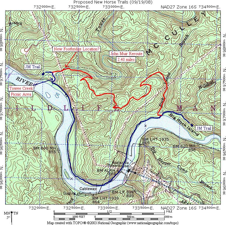
FINAL DATA and MAPS I got a chance to get out and collect the final data on the completed reroute this past week. I started at Towee Creek and walked the route northbound collecting wheel measurements, then turned around and collected GPS data headed back southbound. I believe that I have some data types for everyone. For the Board, I have attached a map of the reroute. For Mr. Parkay I have attached a text file containing 105 GPS points. Hopefully Mr. Parkay can spread this creamy data all over one of his toasty maps! For Marty, I have attached a “tpo” file, and the following detained wheel data:
Distance along Route (Feet)
Significant Feature
00000
Begin reroute on western end (near Towee overflow parking)
00082
Center of blacktop road, trail crossing point
00179
Enter old road bed
00643
Enter Towee Creek
00684
Leave Towee Creek
02179
Leave old road, begin side hill
02218
Switchback
02843
Rounded turn on ridge top, end side hill
03128
Leave ridge top, begin side hill
04608
Ridge top, end side hill
05095
Leave ridge top, begin side hill
05777
Rounded turn on ridge top, end side hill
05942
Leave ridge top, begin side hill
06945
Pass through gap in ridge
08285
Enter old road bed
08400
Rounded turn of old road bed on top of ridge
08957
Switchback at old road intersection
12211
Enter flat mill set area (potential campsite)
12464
Leave flat mill set area, begin side hill
12681
(2.40 miles)
End side hill and reroute on eastern end near Rock Island Branch
Friday, December 12, 2008: Rick Harris removed all the BMT diamonds on the old trail from Towee Creek to a ways past the powerhouse. He did not remove the FS Trail 152 markers since he did not know whether Steve Biatowas wanted to keep the old trail marked. If he does, then sometime in the future the trail markers should be repainted and additional ones added, since there are not many there anymore with the diamonds gone. Also the trail from Towee Creek to the powerhouse needs some brushing out and a few downed trees cut out with chain saws.
Volunteer Hours for Rick HarrisTravel time: 2 hoursWork time: 2 hoursTotal Time: 4 hours
Saturday, April 4, 2009 - John Muir Clean-up Hike – 3 or 6 miles, easy. Hike Leader: Debbie Flower: 476-3907. Weather permitting, we will meet at Childer’s Creek Trail Head at 9:00 a.m. The hike is a beautiful, easy 3 mile trail along the Hiwassee River. It can be either a 3 mile or a 6 mile hike depending on time and car shuttle. Please bring gloves, clippers, water and a snack/lunch. Trash bags will be provided. If you plan on attending, please call the hike leader by Friday evening, April 3rd at 476-3907. Directions: If coming from Cleveland, go to and through Benton, turn right onto Rt. 30 towards Reliance, cross the bridge at Webb’s Store, cross the railroad tracks, turn immediately right at Rosie’s Restaurant and follow the road until Childer’s Creek sign on right.
The fog lifted and we were amazed to see beautiful flowers blooming, several adventurous fishermen in the river and three large horses coming straight for us. And, oh yes, as this was a clean-up hike, we collected about ¼ of a bag of trash. The trail was very clean, as we snipped, clipped and sawed our way to Big Bend. Abby had a lot of fun swimming in the river and racing up and down the trail. Taylor Morris discovered the use of a hand saw. Clayton Pannell met us on the trail and offered to be the shuttle and Randy Morris and Debbie Flower enjoyed the conversation. Hikers: Debbie Flower, Randy Morris, Taylor Morris, Clayton Pannell and Abby Flower.
Wednesday, April 8, 2009: Ken got out today and wheeled the old section of the John Muir Trail from the Powerhouse to the upstream intersection with the new reroute near Rock Island Branch. That gave him all the data that he needed to get the correct information in the Databook file. He sent this data to Bob Ruby for updating the BMT Databook, soon to be republished.
Monday, June 8, 2009 - BMTA Walkthrough BMT Sections 13c-d from Big Bend to Wildcat Creek. Betty Petty. Report attached.
Friday, June 19th, 2009 - BMTA Walkthrough BMT Section 14a from Towee Creek to Coker Creek. Carol & Carroll Guhne. Report attached.
Wednesday, October 7, 2009 - BMT Sections 13d-13e - Coker Creek to Towee Creek. Rick Harris and Steve Biatowas started from Coker Creek and logged out 44 trees before running out of gas about 3/4 mle short of Towee Creek. 12 trees remain. The day started out with rain on the way to the trailhead, but it stopped raining by the time we got to Coker Creek and we ended up with a beautiful blue sky. We ran into 2 hunters with dogs (boar hunting season) and the Chattanooga Hiking Club on their weekly Wednesday hike. There is one section of the trail where the trail will have to be rebuilt along the reroute due to a tree falling with its rootball and taking the trail with it. The trail needs brushing out, especially the first mile or so from Coker Creek, but it all could use some brushing out, which we plan to do on the October monthly BMTA worktrip. Steve and I also plan to go back in two weeks to log out the Coker Creek Falls Trail. The Narrows and other stretches of the Hiwassee were especially beautiful with lots of water in the river from all the rain. On the way back to retrieve our cars, there were hunters and dogs everywhere. We helped two sets of hunters reunite with 4 of their lost dogs. Hours worked are below:
Name
Travel Hours
Work Hours
Totals
Rick Harris
3
7
10
Steve Biatowas (USFS employee)
(3)
(7)
(10)
Volunteer Totals
3
7
10
Saturday, October 24, 2009: BMT Sections 13d-13e - Towee Creek to Coker Creek. Four workers (Rick Harris, Eric Eades, Richard Sullivan, and Regina Reiter) nearly completed work on this section on this cold cloudy Saturday BMTA worktrip. We logged out the remaining 12 trees near Towee Creek and brushed out the reroute and about 2 miles of the distance from Coker Creek toward Towee Creek. Also, while returning from the east end of the reroute to the Powerhouse parking area, we logged and brushed out about half of this section of the old BMT/JMT. All that remains is to brush out the middle one mile of this section and to finish off the 1/2 mile on the old BMT/JMT near the Powerhouse. Rick Harris plans to return on Sunday to finish off the brushing out and Steve Biatowas (Ocoee/Hiwassee District trails tech) will probably go in soon to log out the old route near the powerhouse. Regina is a thru-hiker who is hiking the BMT her second time. She joined us for our work trip today and she told us this time the BMT is in much better shape in the TN/NC section than when she previously thru-hiked the trail. She had no problems at all this whole time on the BMT. Hours worked are below:
Name
Travel Hours
Work Hours
Totals
Rick Harris
3
6
9
Eric Eades
4
6
10
Richard Sullivan 3 6 9 Reginia Reiter 0 6 6 Volunteer Totals
10
24
34
Sunday, October 25, 2009: BMT Section 13d-13e - Towee Creek to Loss Creek. Rick Harris today finished off the brushing out on the middle section from the east end of the reroute to a short distance west of Loss Creek, a distance of about 1.50 miles. The section from Towee Creek to Coker Creek is now maintained to standards. My volunteer hours are below:
Rick Harris, travel time 2 hours, work time 7 hours, total volunteer hours, 9 hours.
Sunday, December 20, 2009: BMT Section 13c - JMT Big Bend to Towee Creek. Eight workers wanting to work off some of the holiday party eats and to avoid going to the malls with their wives came out to work on the BMT this chilly somewhat snowy and wet day. We met at the Towee Creek parking area then split up into two groups. One group worked from Big Bend to the middle and the other from Towee Creek to the middle. We logged out 16 logs and brushed out this entire section. It was too wet to touch up blazes, so this will have to be done at a later date. With this big crew, it only took 2 hours to complete the work, so we finished at 11 AM, then several of us went to the Black Bear Cove Restaurant for a wonderful $11.99 Christmas Buffet. Four of us then went to Lost Creek Campground and worked on the BMT south toward McFarland Road on BMT Section 12d for another 4 hours cutting out 12 trees and brushing out the trail for about 1.5 miles. Two of the trees were huge, about 20 inches in diameter. One of us (Richard Sullivan) went to the Kimsey Highway BMT crossing and worked north on BMT Section 12c with his brush cutter before heading on home. The hours below reflect the hours spent on all three sections in toto.
Name
Travel Hours
Work Hours
Totals
Rick Harris
2.5 6 8.5 Richard Sullivan 3.5 3 6.5 Eric Eades 3.5 2 5.5 Tom Smith 3 6 9 Rick Foster 3 6 9 Larry Dunn 2 6 8 Bill Hodge 2 2 4 James Anderson 2 2 4 Volunteer Totals
21.5 33 54.5 Of note, a couple of large trees that had fallen across the road had earlier been partially cut up to clear minimal passage; we cleared the pushed aside logs and the rest of those off the roadway.
Monday, December 21, 2009: Coker Creek Area, BMT Section 13e - Four Coker Creek Ruritans (Marc Bernatti, Rick Pease, Steve Simmons, Garry Long) cleared up the FS road from Duckett Ridge Rd leading down to Coker Creek Falls parking lot. There were a number of blow downs, fall downs, and broke downs obstructing the roadway which we cut up or pulled down and removed off the road and sides. Also a large fully branched pine had twisted off near the trail head and was blocking the trail and drainage of the 'camping' and fire pit area. We put in 8+ hours total( 2 each), including travel; about an hour.Saturday, March 27, 2010: TN/NC BMTA Saw-A-Thon #3 - Eleven maintainers got out on this beautiful warm spring day for the third monthly saw-a-thon to clear all the deadfalls from the fierce winter winds. Of note, Bill Hodge ran into a group of 20 backpackers at the BP Station in Tellico Plains heading out onto the BMT. Nice to know our trail is being used. We split into four groups as below:
Group 1 - Round Top to Sledrunner Gap, BMT Section 16b - Kendall Hobson (section maintainer), Marty Dominy (chain saw) and three friends of Kendall (John Mason, Glenn Crowe and Ernest Jones) went in via the Round Top shortcut and cleared 10 trees almost to Sledrunner Gap, three of which were quite sizable. They then returned to their cars at the base of the Round Top shortcut. They plan to return soon via Beaverdam Bald to finish off the section.
Group 2 - Sandy Gap to Tate Gap, BMT Section 15b & w15c - Richard Sullivan (chain saw) and Bill Hodge (crosscut) cleared 40 trees on this section (13 with crosscut, 27 with chainsaw). They moved another 20 or so off the trail without having to cut them. The worst section was near Six Mile Gap where two large pines had nearly obliterated the trail. They entered from Sandy Gap and came out Doc Rogers Road. They passed one backpacker on the trail.
Group 3 - John Muir Trail - Big Bend to east end of reroute - BMT Sections 13c & 13d - Rick Harris (chain saw) and Tom Smith cleared 23 trees from the BMT and the old route of the BMT/JMT. They started at the powerhouse and went 1 mile upstream to the end of the reroute, clearing a few trees, then took the reroute to Towee Creek and on to Big Bend. This section was remarkably clear of trees. By the time we reached Big Bend, we had only cut about 12 trees. Since we finished early due to the good condition of the trail, we decided to log out the short 0.5 mile section of trail along the river just downstream from the big canoe/kayak parking area (the old route of the BMT and JMT). In this swampy and now poorly maintained section we cleared another 11 trees. So now the entire loop trail is clear of trees. No brushing out is currently needed except for the old segment of the JMT/BMT downstream from the canoe/kayak parking area. We do not plan to further maintain this segment. The fishermen will probably keep it passable now that we have the trees logged out. There were several day hikers we passed today on the trail, about a dozen or so.
Group 4 - McFarland Road to Lost Creek Campground and a short ways downstream from there - BMT Sections 12d & 12e - Steve Cartwright (chainsaw) and Larry Dunn left a car at Lost Creek Campground, then drove to the McFarland Road Crossing. The cleared only 2 trees with chainsaw from there to Lost Creek and another 2 trees on the segment along the edge of Lost Creek. They also removed several smaller trees with a hand saw and picked up trash. This section was in remarkably good shape, considering all the high wind storms we had over the winter months. Total Volunteer Hours are as follows:
Name
Segment - District Travel Hours
Work Hours
Totals
Marty Dominy 16b - Cheoah 5 7 12 Kendall Hobson 0.5 7 7.5 John Mason 0.5 7 7.5 Glenn Crowe 0.5 7 7.5 Ernest Jones 0.5 7 7.5 Richard Sullivan 15b/15c - Tellico 3 5.5 8.5 Bill Hodge 3 5.5 8.5 Rick Harris 13c/13d - Ocoee 2 5.5 7.5 Tom Smith 2 5.5 7.5 Steve Cartwright 12d/12e - Ocoee 2 5.75 7.75 Larry Dunn 2 5.75 7.75 Volunteer Totals
21 68.5 89.5 Cheoah Ranger District Total Volunteer Hours = 42 hours
Tellico Ranger District Total Volunteer Hours = 17 hours
Ocoee/Hiwasse Ranger District Total Volunteer Hours = 30.5 hoursTuesday, June 1, 2010: BMT Section 13d - Towee to Wildcat Creek - I [Larry Dunn, maintainer] had not yet been on this part of the new "bypass" section starting at Towee Creek so I checked it out solo today. I covered the new trail bypassing the TVA powerhouse and then made the complete loop back to Towee Creek.A lot of limbing and brushing was needed with loppers. Several small trees were cut and a top section of one tree. Since my hike in February a big tree has fallen in the area where the trail returns to the Hiwassee. We will need to revisit this for chainsaw work. The main trunk divides into two trunks and the cut will have to be through these two still-large trunks. I got most of the limbs and tree sprouts but much weed removal is needed. I plan to return with my co-maintainer Tom Smith soon to finish up the work on this section. My volunteer hours for this work trip are as follows:Larry Dunn - 2 hours travel. 6 hours work = 8 total volunteer hoursTuesday, June 29, 2010: BMT Section 13e - Coker to Wildcat Creek - Larry Dunn and Tom Smith spent the day brushing out the two miles or so of the JMT going west from Coker Creek. Plans are to go back in next week to finish the rest of this section coming in from the powerhouse. Volunteer hours are as follows:
Larry Dunn - 2 hours travel, 4 hours work = 6 total volunteer hours
Tom Smith - 2 hours travel, 4 hours work = 6 total volunteer hoursThursday, July 6, 2010: BMT Section 13e - Coker Creek to Wildcat Creek - Today Tom Smith and Larry Dunn finished weeding the western portion of this section, estimated at just over 2 miles. On a day that was in the upper nineties most places, this trail under shade and with a breeze on the Hiwassee was fairly tolerable with nice views of the river and the gorge at times. Tom used a string-type weedeater and Larry used the blade-type borrowed from Rick Harris. Thanks for the use of this effective weed and brush cutter. I hope to have one within a day or two. The only mishap was a yellow jacket sting on Tom's hand. Despite impressive swelling and pain, he persevered. Once they upset the yellow jackets with the weed eater and retreated while they calmed down, they stepped more cautiously and quietly over the large nest (lots of inhabitants buzzing us) with no problem. It is on one of the steepest places on the trail with no option to go above or below the nest.
Tom Smith - 2 hour travel, 7.5 hours work
Larry Dunn - 2 hour travel, 7.5 hours workMonday, August 9, 2010: BMT Section 13e - Wildcat Creek to Coker Creek - Tom Smith and Larry Dunn met at Webb's Store and worked their way on Section 13e starting at the junction of the BMT and the John Muir. We cleared the west half of that section to the point where we had run out of trimmer gas on June 29, thus completing the weed and limb work on 13e. Volunteer hours are as follows:
Tom Smith - 2 hour travel, 4 hours work
Larry Dunn - 2 hour travel, 4 hours workMonday, September 6, 2010: BMT Section 13d - Towee Creek Wildcat Creek - Tom Smith and Larry Dunn met at Webb's Store at 8 a.m. and did chainsaw work starting at about 8:15 on the section east of the Apalachia Powerhouse. The main objective was a large fallen tree whose two divided trunks (one about 18 and the other about 15 inches) had to be cleared. This was about a mile east of the powerhouse. On the return trip, they removed an impressive treetop newly fallen and requiring a number of chainsaw cuts of top limbs. They wrestled a sizable rotten but wet and heavy log (about 12 inches X 12 feet) out of the trail. Finally, another newly fallen tree (about 8 inch diameter) was chain-sawed from overhead, but too low for a backpack. They returned to the trailhead at 10 o'clock. The Benton MacKaye Trail is now in good condition from the powerhouse to Coker Creek on the Hiwassee, assuming nothing new has developed since our weed-whacking of early July. Tom will soon be hunting and will scout the trail. I will soon revisit the Lost Creek section with lopper and weed-eater.
Larry Dunn - 2 hours travel, 2 hours work = 4 total volunteer hours
Tom Smith - 2 hours travel, 2 hours work = 4 total volunteer hoursMonday, December 20, 2010: BMT Section 13d - Towee Creek to Wildcat Creek - Larry Dunn and Bill Lundin met at Towee
Creek parking lot at 8:45 AM. They left Larry's car at the parking lot and drove Bill's to the Apalachia Powerhouse. They walked in on the John Muir trail for 3/4 mile to where the BMT intersects John Muir. They then hiked the 2.6 miles back to Towee Ck parking lot, clearing 7 blow-downs on the way with Larry’s chainsaw. One was a major blow-down located approximately 100 feet from the intersection of the BMT and John Muir. 90 feet of trail was blocked by a large fallen oak (at least 3 feet diameter) and 3 or 4 other trees that were taken down with it. It took them almost 4.5 hours to clear this.
Larry Dunn: 2 hrs travel, 7.5 hrs work
Bill Lundin: 3 hrs travel, 7.5 hrs workSaturday, January 22, 2011: BMT Section 13d-e and 14a - Towee Creek to TN68 -
Nine trail work volunteers converged to three areas of the Benton MacKaye Trail to work at low elevation on this beautiful crisp winter day. The original plans were to work on the trail in the Heart of Darkness and up near Waucheesi Bald, but they had to move to lower elevations and asphalt access due to closed forest service roads and too much snow and ice at high elevations.Richard Sullivan, Tom Smith, David Blount, and a new volunteer Garry Day from down around Ocoee, TN, met at the TN68 crossing of the BMT south of the village of Coker Creek and logged out 11 deadfalls on the trail from there to the BMT bridge over Coker Creek and also cleared brush away from the trail. Bill Hodge and Larry Dunn logged 5 trees off the trail from the Coker Creek Bridge going downstream along the Hiwassee River toward the Apalachia Powerhouse.Rick Harris, Ken Jones and Bobby Mitchell met at the Towee Creek Access along the Hiwassee River along with Steve Biatowas (Ocoee/Hiwassee Ranger District Trails Tech). They first scoped out various possible bridge locations to get over Towee Creek. Plans are to possibly construct a new synthetic material bridge over the creek similar to the bridges used on the Cumberland Trail. Next step is to get the hydrologist in to look over the possible crossing sites. Once a site is chosen, then the BMTA can work with the national forest on getting the appropriate surveys done and find a funding source such as a TN Greenways & Trails RTP Grant and/or an American Hiking Society Grant.After finishing with the bridge scoping, they then went east on the John Muir Trail Reroute Section and rebuilt a short section of trail around a large hole in the trail created when a large tree right on the edge of the trail fell and took the trail with it. They also hiked the rest of the reroute to the intersection with the old JMT, clearing two large logs off the trail and removing brush which was encroaching upon the trail. Unfortunately, they found another large hole in the trail near the east end of the reroute which is going to take a large crew and a whole day to fix. Since the hole is on a steep sideslope on a rock face, the hole will have to be filled with rocks to create a rock step staircase.
Afterwards, Ken Jones and Rick Harris checked out the new gate which has been placed on the road leading up to the south end of the Lost Creek Section near the Hiwassee Outfitters campground. The previous standard issue farm gate has now been replaced by a heavy duty steel bar gate. It will be much easier for hikers to get through this gate than the old one.Volunteer hours on Sections 13d-e are below:
Name
Travel Hours
Work Hours
Totals
Rick Harris 2 6 8 Ken Jones 1.5 6 7.5 Bobby Mitchell 2 6 8 Bill Hodge 0.5 4.5 5 Larry Dunn 3 4.5 7.5 Volunteer Totals
9.5 27 36 Monday, January 31, 2011: BMT Section 13e - Towee Creek to Wildcat Creek - We put out a call for help in hauling in a lot oftools and equipment, and 15 volunteers answered the call on a somewhat rainy morning. The objective of the trip was to install a new sign at the junction of the old trail and new reroute at
Rock Island Branch, and repair tree damage to the tread. The repair required moving rocks and dirt and completing rock steps in a 3' deep hole left by an upended root ball. We also did some additional tread work on the steep slope below the root ball. By the time the small sign crew finished installing the sign, the rock crew had finished their work. It was such a joy to have all of the help that we finished the work in just a few hours. On the way back downstream to the Powerhouse, we also repaired another root ball hole in the tread of the old section of the John Muir Trail. It drizzled enough for many of us to put on rain gear, but we were back at the vehicles by the time the rainfall got serious. Here are the volunteer hours for this work trip:
Name
Travel Hours
Work Hours
Totals
Ken Jones
2
3
5
Roger Taylor
1.5
3
4.5
Tom Smith
2
3
5
Tazz Reid
1.5
3
4.5
Blue Goodson
2.5
3
5.5
Clayton Pannell
1.5
3
4.5
Larry Dunn
2
3
5
Bobby Mitchell
2.5
3
5.5
Richard Harris
2
3
5
Philip Gooch
1.5
3
4.5
Jim Sirmans
1.5
3
4.5
Bill Hodge
2
3
5
Bill Lundin
3
3
6
Monty Simmons
1.5
1.5
3
Betty Petty
1.5
1.5
3
Totals
28.5
42
70.5
Saturday, April 23, 2011 - BMT Sections 12b,c,
d & 13b,c,d - Spring Saw-A-Thon - A total of 10 workers showed up on this beautiful warm Saturday before Easter to saw logs off the BMT. Six worked on Section 12 from Kimsey Highway to the Hiwassee River, two in each saw crew going to all three sections. Kimsey Highway to McFarland Road was Rick Harris and Bill Lundin, McFarland Road to Lost Creek Campground was Ken Jones and Jim DeBernardi, and the Lost Creek Section was Bobby & Joanne Mitchell. North of the Hiwassee on the John Muir Trail were Darcy Douglas and Marty Dominy from Towee Creek to the Childers Creek Trailhead, and Bill Hodge and Larry Dunn from Towee Creek to end of the reroute and back via the old JMT along the river. Darcy and Marty also repainted blazes on Section 12c. Thus the trail is clear of blowdowns from Kimsey Highway to Wildcat Creek, a distance of 18.4 miles. Volunteer hours are below:
May 6, 2011 - BMT Section 13e - Coker Creek to Wildcat Creek - We cleared about 20 trees off this section of the BMT which we had heard was really bad per reports from thru-hikers. Some of the trees were big with multiple branches over the trail, blocking the trail forcing hikers to crawl through or go around the ends of the trees. We were quite surprised how bad this section of the trail was, considering it was clear of trees as recently as about 6 weeks ago per the section maintainers Tom Smith and Larry Dunn. We also cleared a few trees from the old JMT route between the end of the reroute and the powerhouse, but there are several trees still needing work, including one huge 30 inch or so tree completely blocking the trail with a long walk-around. Volunteer hours are below. Volunteer hours are below:
Name
Travel Hours
Work Hours
Totals
Rick Harris
2 6 8 Bill Lundin 3 6 9 Ken Jones 2 6.5 8.5 Jim DeBernardi 1.5 6.5 8 Bobby Mitchell 2 4 6 Joanne Mitchell 2 4 6 Marty Dominy 5 6.5 11.5 Darcy Douglas 5 6.5 11.5 Bill Hodge 1.5 5.5 7 Larry Dunn 2 5.5 7.5 Volunteer Totals
26 57 83 Friday, October 7, 2011 - BMT Section 13c-d - Big Bend to Towee Creek on John Muir Trail - Three of us logged and brushed out this section in preparation for work on the tread by the American Hiking Society Volunteer Vacation Group coming this next week. We removed two trees and all the brush. Afterwards, Bill Lundin continued on east on the JMT past Towee Creek brushing out for perhaps another mile. Volunteer hours are as follows:
Name
Travel Hours
Work Hours
Totals
Rick Harris
2
6
8
Tom Smith
1.5
6
7.5
Larry Dunn 2 6 8 Volunteer Totals
5.5
18
23.5
Name
Travel Hours
Work Hours
Totals
Rick Harris
2
4
6
Bill Lundin
3
5
8
Larry Dunn 2 4 6 Volunteer Totals
7
13
20
Saturday, October 8, 2011 - BMT Section 13b - Childers Creek to Big Bend on John Muir Trail - It was a gorgeous
day as five hikers set forth to clean up the three mile “Adopt a Trail” section of the John Muir Trail along the Hiwassee River. The ladies clipped and snipped along the trail while Clayton Pannell and Randy Morris did massive repair work on the trail by the stairs. Hike Leaders: Clayton Pannell and Deborah Flower. Hikers: Karen Young, Rebecca Levings and Randy Morris.
Friday, October 14, 2011 - BMT Section 13c - Big Bend to Towee Creek on the John Muir Trail - This was day 4 of work for the 2011 American Hiking Society Volunteer Vacation Crew. The day started out foggy but cleared off and was cool and clear by the end of the day. We put up a new sign at the Towee Creek trailhead and did treadwork from Towee Creek about half of the way toward Big Bend. This is a steep sideslope section down to the road and the river. The trail tread is now safe to walk without fear of sliding off the edge. Afterwards, we all went up to the swinging bridge by the powerhouse and then to the overloop at the bend in the river. All day TVA had one generator open, giving us great river views.
Name
Travel Hours
Work Hours
Totals
Clayton Pannell 1.5 6 7.5 Randy Morris 2 6 8 Karen Young 2 3 8 Rebecca Levings 2 3 8 Deborah Flower 2 3 8 Volunteer Totals
9.5 21 39.5
Name
Travel Hours
Work Hours
Totals
Rick Harris
0.5
8
8.5
Steve Biatowas - USFS
(8)
(8)
Dick Evans 3
8
11
Jim Bishop 3 8 11 Bob Ruby 3.5 8 11.5 Eric Randall - VV 8 8 Kathy Stege - VV 8 8 Sarah Slover - VV 8 8 Betty Gill - VV 8 8 John Carmichael - VV 8 8 Tina Temple - VV 8 8 Tina Stambaugh - VV 8 8 Bill Twitty - VV 8 8 Totals
10
96
106
Sunday, January 29, 2011 - TN/NC BMTA Worktrip SAW-A-THON - Several groups went to various sections of the BMT to take care of specific problems, as below. The workers also filled out the Annual Walkthru Reports on the sections they covered. Afterwards, several of us met for dinner at the Mexican restaurant in Copperhill. Fahitas seemed to be the diet of the champions.
Thursday, April 5, 2012 - BMT Sections 13c-d and Oswald Dome Trail - Seven workers came out for this work trip to tackle a couple of large and dangerous logs on steep sideslopes. We first went to the BMT/John Muir Trail between Towee Creek and Big Bend. There was a very large tree with the root ball sitting on a bluff above the trail and the tree extending down to the trail. While we had three people down below on the road to stop traffic, we secured the root ball with a come-along, then cut the root ball away from the trunk. Then we cut the tree is two other places to make the tree safe. The root ball and the segments we cut rolled down the hillside toward the road, but did not make it all the way. We then logged a 16" tree off the trail, then four of us went to the BMT section east of Towee Creek. We brushed out this section and planned to log it out following reports of several logs. However, it was obvious someone beat us to it. There were no logs across the trail except for one fresh branch. We did see evidence of very recent logging out. The other three went to the Oswald Dome Trail and hiked about 2 miles up the trail to a very large log estimated to be about 30" in diameter across the trail on a steep sideslope.BMT Section 13d-e - John Muir Trail Towee Creek to Loss Creek (Ocoee-Hiwassee District) - Richard Sullivan and Jim O'Brien logged out 21 trees off this section of the trail. They also did some lopping, but more needs to be done this spring or early summer. This section is now completely clear of trees across the trail, thanks to this hard working crew.
Name
Travel Hours
Work Hours
Totals
Richard Sullivan 3 6 8.5 Mike O'Brien
3.5
6
9
Totals
6.5
12
18.5
BMT Section 13e - Coker Creek to Loss Creek (Ocoee-Hiwassee District) - Zoe and John Zardis, new maintainers for section 14a, tackled the section of the JMT from Coker Creek past Loss Creek a ways with gas-powered brush cutters. There were no logs across their section of the trail so they did not have to cut out any trees with hand saws, but they did quite a bit of brushing out. When they got to Loss Creek, though their assignment was to quite there due to likely high water in Loss Creek, they were able to cross the creek and continue on for a ways and saw the work of the crew coming in from the other end on logging out trees.
Name
Travel Hours
Work Hours
Totals
Zoe Zardis 1.5 6 7.5 John Zardis
1.5
6
7.5
Totals
3
12
15
day, April 24, 2012 - BMTA AHS VV Day 2 - BMT Sections 13e - We worked on the John Muir Trail/BMT doing tread work just east of Wildcat Creek where the trail switchbacks up the ridge then back down the other side of the ridge. (BMTA helpers were Rick Harris, Bob Ruby, and USFS employee Travis Schwarzer)
Name
Travel Hours
Work Hours
Totals
Rick Harris 2.5 5 7.5 Steve Cartwright 1.0 6 7.0 Tom Smith 2.5 5 7.5 Chris Beck 0.5 5 5.5 Steve Biatowas USFS 0.5 6 6.5 Jim Muhonen 1.0 6 7.0 John Kalabus 1.0 5 6.0 Volunteer Totals
9.0 38 47 Tuesday, July 24, 2012: BMT Section 13d-e - Towee Creek to Coker Creek - Larry Dunn and Steve Biatowas USFS logged out the BMT from the east end of the JMT reroute to Coker Creek, removing 6-8 logs. Also, they came across a yellow jacket nest which they poured gasoline down. The trail was OK as to brushing out, but will probably need brushing out near the end of the summer.
Name
Travel Hours
Work Hours
Totals
Richard Harris
0.5
8.5 9
Bob Ruby 0.5
8.5 9 Travis Schwarzer USFS 0 8.5 8.5 John Carmichael - VV 0 8.5 8.5 Elizabeth Miller - VV 0 8.5 8.5 Mona Lloyd - VV 0 8.5 8.5 Karen Stearns - VV 0 8.5 8.5 Jim Kern - VV 0 8.5 8.5 Steve Rountree - VV 0 8.5 8.5 Patty Pikul - VV 0 8.5 8.5 Jane Greischar - VV 0 8.5 8.5 Gretta Farmer - VV
0
8.5 8.5
Totals
1
93.5
94.5
Saturday, July 21, 2012 - BMT Section 13b - JMT Childers Creek to Big Bend - Clayton Pannell and Robert Owenby partially logged our their section of the BMT. They started from Childers Creek and only got about half way clearing out what they could. There is presumable much more work to be done on the second half of this section. These trees probably all came down the day of the high straight winds July 5.
Name
Travel Hours
Work Hours
Totals
Larry Dunn 3 8 11 Steve Biatowas USFS
(1.5)
(8)
(9.5)
Totals
3
8
11
Saturday, July 28, 2012 - BMT Section 13a-c - JMT area - Eight maintainers came together to clear the BMT from the Childers Creek Trailhead to the Towee Creek Trailhead along the JMT. Robert Owenby started from the Childers Creek trailhead and headed toward Big Bend with a lawnmower, mowing down the high weeds, at least until he hit something and bent the lawnmower blade. He then came around to Big Bend to join the rest of us. Rick Harris, Clayton Pannell, and Lara Winner with chainsaw in hand logged out the BMT from Big Bend to a point a short ways past the stone stairs heading toward Childers Creek, removing several logs. At the turn around point they came upon the huge mess of trees left by Clayton and Robert the previous weekend. By then Robert had joined us. We were able to remove two large trees off the top, one of which was about 18" in diameter, but the 24" tree flat on the ground was two large to get with our smallish chain saw. One can climb over it, but we will have to ask Steve Biatowas to come in with his long arm saw to get this one. Richard Sullivan, Mike O'Brien and Roger Taylor brushed out the trail heading the other direction, from Towee Creek to Big Bend. They cut out some small trees, but only left on larger tree which is flat on the ground and easy to step over. When they returned, they also headed down toward Childers Creek to brush out the section the others were logging out. Thus, the JMT from Childers Creek to Towee Creek is now in good shape, except for the one huge tree they could not get. Larry Dunn painted blazes along the roadway from Childers Creek to the Lost Creek section, as planned. Also, a few days before, Larry Dunn and Steve Biatowas had logged out the BMT from Towee Creek to Coker Creek. And before that, a crew had logged out the BMT along the Lost Creek section. Thus the entire BMT from Lost Creek Campground to Coker Creek should be in very good shape.
Name
Travel Hours
Work Hours
Totals
Clayton Pannell 1 4.5 5.5 Robert Owenby
2
4.5
6.5
Totals
3
9
12
Tuesday, August 14, 2012 - BMT Section 13b - Childers Creek Section of JMT - Clayton Pannell and Robert Owenby finished brushing and logging out their section with the help of Steve Biatowas. They mowed with lawn mowers from about a mile in from each end of the trail, cut out two new downfalls since the last trip and with the help of Steve Biatowas, USFS, they removed the huge tree about in the middle of the section that the crew the previous month was unable to clear with their short chainsaws.
Name
Travel Hours
Work Hours
Totals
Rick Harris 2 5 7 Clayton Pannell 1 5 6 Robert Owenby 1 7 8 Lara Winner 3.5 5 8.5 Richard Sullivan 3 5 8 Mike O'Brien 3 5 8 Larry Dunn 1.5 3 4.5 Roger Taylor 1.5 5 6.5 Volunteer Totals
16.5 40 56.5 Friday, November 16, 2012 - BMT Section 13e - Towee to Coker Creek - Tom Smith and Zoe Zardis logged out this section, removing 8 trees from the trail corridor. Afterwards Zoe logged out the section from TN68 up to the motorcycle trail, section 14b, revoing several small trees with a hand saw.
Name
Travel Hours
Work Hours
Totals
Roberty Owenby 2 7 9 Clayton Pannell 1 7 8 Steve Biatowas USFS
(1.5)
(8.5)
(10)
Totals
3
14
17
Name
Travel Hours
Work Hours
Totals
Tom Smith 1 4 5 Zoe Zardis 1.5 7 8.5 Totals
2.5
11
13.5
Contact the Webmaster