Cherokee Hiking Club
198 Crews Drive, Benton, TN 37307
![]()
Benton MacKaye Trail
Trail Maintenance
Benton
MacKaye Trail -
Section 18
Fodderstack Trail
Thursday, February 28, 2008
Thursday, March 27, 2008
Thursday, April 3, 2008
Monday, April 7, 2008
Thursday, April 17, 2008
Thursday, August 28, 2008
Thursday, September 25, 2008
Friday, January 30, 2009
Thursday, February 12, 2009
Friday, February 20, 2009
Thursday, March 19, 2009
Thursday, March 26, 2009
Wed-Thu, June 24-25, 2009
Monday, August 10, 2009
Thursday, October 1, 2009
Friday, October 16, 2009
Tuesday, January 19, 2010
Friday, January 22, 2010
Thursday, January 28, 2010
Thursday, February 11, 2010
Monday, April 5, 2010
Thursday, April 16, 2010
Monday, July 19, 2010
Monday, July 26, 2010
Tuesday, August 3, 2010
Friday, October 1,
2010
Tuesday, October 12, 2010
Thursday, March 3, 2011
Monday, October 19, 2011
Sunday, February 26, 2012
Saturday, April 18,
2012
Saturday, July 7, 2012
Fri-Sat, Aug 31-Sept 1, 2012
The Fodderstack Trail runs 12.5 miles from Farr Gap to Beech Gap in the Tellico Ranger District of the Cherokee National Forest and is in the Citico Creek Wilderness, a bear refuge. The naughty bears are brought to this area from the Smokies. Also, many wild boar frequent this area. This trail follows a ridge top at 4000 to 4500 feet elevation over several mountain tops (Big Fodderstack, Little Fodderstack, Chestnut Knob, and Rockstack. This trail is part of the Benton MacKaye Trail (FS Trail 2) and also is designated as FS Trail 95. Several great views and big campsites are along the trail, though water is infrequent due to its ridgetop location. Horses are allowed on this trail.
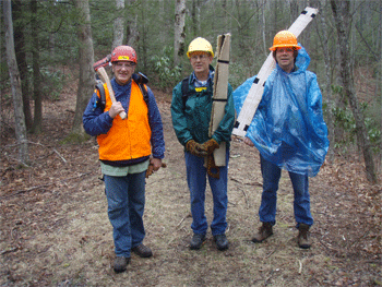
February 28, 2008: BMT Section 18b. Tazz Reid and Ken Jones worked on clearing a big tree on Big Fodderstack. They hiked up the Mill Branch Trail to Fodderstack, then turned south and hiked to the tree location, about 0.2 miles south of the Pine Ridge Trail intersection. By the time they reached the tree, they were hiking in about 8" of snow. They had both fallen so many times they lost count, and their gloves were wet, leading to really cold fingers. The tree turned out to be an oblong shape where they had to saw (30" x 18"). They used 3 wedges and were able to saw it from the top down all the way through. They placed a skid pole underneath before they made the second cut, but the large piece slid off and blocked the trail. With the bad footing and running out of time, they were forced to abandon it. There is plenty of room for hikers to get through, but it still poses a problem for the horse riders. They plan to go back this next Thursday to remove the piece, and clear some more blowdowns on Section 18b.
Here is our time for the day:
Name Volunteer HoursKen Jones 10Tazz Reid 10March 27, 2008: BMT Section 18b. We started a project of logging out all of the blowdowns on Fodderstack Trail yesterday. We began at Farr Gap, and sawed 12 blowdowns from there to the Crowder Place. We also cleared a number of other trees and limbs that we could haul off the trail. We had received a report of trash along the trail, so we took one large garbage bag with us. We picked up so much trash that we almost ran out of room in this large bag. We met one young backpacker close to Little Fodderstack on his way out from camping at Big Stack Gap the night before. We hiked back down the Crowder Branch Trail to come out for the day. We lost the trail somewhere on the upper end, then headed down to the stream to find it again. Crowder Branch Trail is in really bad shape, both from a maintenance standpoint and failing to meet trail design standards for much of the trail.
Here is our time for the day:Name Volunteer HoursKen Jones 9Tazz Reid 9Jim Holland 10
April 3, 2008: BMT Section 18b
Four of us continued work on logging out Fodderstack Trail yesterday. We hiked in from Farr Gap to the Crowder Place to begin work for the day. We had one brief period of moderate rain on the way in, but overall the day was still a good work day. We sawed 8 trees off the trail from the Crowder Place south to about 0.2 miles beyond Big Stack Gap. Fodderstack Trail is now clear of blowdowns for all of Section 18b, from Farr Gap to Pine Ridge. We will continue work on logging out Section 18a on our next work trip planned for next Monday.
Here are the volunteer hours for the day:
Name Travel Time Work Time TotalKen Jones 2 7 9Tazz Reid 2 7 9Jim Holland 3 7 10Rick Harris 1 7 8
Monday, April 7, 2008: BMT Section 18a
We continued working to clear all the blowdowns from the Fodderstack Trail yesterday. We went up the Pine Ridge Trail and cleared 2 trees from close to the top and very near the Fodderstack intersection. Rick Harris walked up with us and cleared a number of small trees with his new Felco 610 saw on Pine Ridge getting up to the first big tree. From there he left us to hike south on Fodderstack to return to Warden Fields via Brush Ridge and the South Fork Citico. Tazz and I cleared 3 more trees on Fodderstack to Harrison Gap. From this point the trail is now clear all the way back to Farr Gap.Here are our hours for the trip:Name Travel Hours Work HoursKen Jones 2 7.5Tazz Reid 1.5 7.5Rick Harris 1 2Totals 4.5 17Brenda Harris and their dog Jake, who just came along for the hike, climbed to the top of
the Pine Ridge Trail, turned around at the first downed tree since Brenda had to be at a meeting at 2PM. Rick continued on down the BMT south past Harrison Gap, Rockstack, Glenn Gap, Chestnut Top, and Cherry Gap, then on down the new section of the BMT to the intersection with the Brush Mountain Trail, FT 97. The only other blowdowns seen on this section of the BMT were about a half mile into the new section of the BMT just past the campsite.
There were several downed trees in a 1/4 mile section of the trail. Rick then hiked down the unmaintained Brush Mountain Trail to South Citico Creek and back to his car. The going in places was rough. There were not that many blowdowns, but there were lots and lots of tangles of greenbriar. And the hike down the creek bed to Ike Branch and beyond was something Rick would like to not ever repeat again. The going was tough, but the creek is truly beautiful with many waterfalls. There was a lot of water in the creek due to recent rains. The crossing over South Citico Creek was especially interesting, almost dangerous, due to the high water. The total distance was 15.2 miles and overall took 8 1/2 hours. The top speed on the Brush Mountain trail was about 1 mile per hour.
Trail map and profile of Rick Harris's loop hike.
Thursday, April 17, 2008: BMT Section 18a. We continued working on clearing Fodderstack of all blowdowns yesterday. We went in from Beech Gap, and noticed that the carsonite sign post had been pulled out of the ground. I will have to take the post driver back up some time to re-plant it. When Tazz went to start his Bronco back up, it would not start. It turns out that the starter had broken loose, so we parked on the hills for the rest of the day. We cleared 2 trees of the gated road section with the chainsaw, and 6 more trees with the crosscut saw for a total of 8 trees. The entire 13 miles of Fodderstack / BMT should now be clear of blowdowns (if only briefly!).
Other items of note for the Tellico District are that the metal sign prohibiting horses placed at the northern intersection of Fodderstack and Bob Stratton Alternate (inside the wilderness) was gone. There also were signs of recent illegal horse use on the northern section of Trail # 54A to access Bob Stratton Bald. We didn’t see any signs of horse use on the section of Trail # 54A headed back down to Cold Springs Gap (southern section).
Here are our volunteer hours for the day:
Name
Travel Time
Work Time
Totals
Ken Jones
2
5.5
7.5
Jim Holland
3
5.5
8.5
Tazz Reid
2
5.5
7.5
Totals
7
16.5
23.5
Thursday, August 28, 2008: BMT Section 18a. We had plenty of help today. Both Hadorns, both Mitchells, Jim, Robert and myself (7 of us) got a lot done. I think Jim said that we cut 8 trees with the crosscut and ax. Several trees looked to have come down in the recent rains. Robert took down the metal sign and we also applied the decal to the carsonite post just behind the gate. By the way, the gate doesn't have a lock on it. I suspect the chestnut people have left it off, since the tree is bagged. We also completed the slingblading project all the way from the wilderness sign to the end of the old roadbed (where the Brush Mtn Trailhead begins).
I needed a jacket that I didn't bring early this morning, and then it rained on us for a while. When we left, this afternoon, it was still socked in with fog and nice and cool up that high. Everyone was soaked through in the wet vegetation, but on the plus side, the stinging nettles seem to be more managable when wet.
Arlin, and the 2 Hutsells were going with us as of yesterday, but Arlin got called out to South Carolina for something, so I think I might be able to get them next Thursday if you want to dig in #1. Maybe we'll get the Hadorns too, but the Mitchells won't be back with us till the 2nd Thursday in September. Also we still have that log on #2 to cut out. Then we can get to work on the Fodderstack trail bed if nothing else comes up.
Here are our hours for the day. We left the Ranger Station at 8:00 and were back right at 3:00= 7 work hours each. I will put the travel time next to the names.
Tazz Reid: 1
Jim Holland:3
Phil Hadorn: 2
Judy Hadorn: 2
Bobby Mitchell: 2
Jo Ann Mitchell: 2
This brings the SABCH hours in the South Cherokee to 987 hours for 08!Thursday, September 25, 2008: BMT Section 18b. We worked this past Thursday to repair a problem spot on Fodderstack Trail, located just northeast of the Pine Ridge Trail intersection. This was the spot where Tazz and his horse both hit the ground on a ride a few months back. We hiked up the Pine Ridge Trail, then turned south on Fodderstack (BMT Section 18a). We then hiked to the high spot to see if we could find any trees down, since we had a report from a horse rider of a big tree in this area. We found the trail all clear to this spot on the shoulder of Big Fodderstack. We then hiked back to Pine Ridge and down to the spot of the accident. We chopped a tree off the trail, and then used part of the tree for cribbing. We dug the trail in wider in this spot, and also improved some more narrow spots in this area for a total of 85’ of trails improvement. We also cleared a total of 7 trees from Fodderstack and Pine Ridge Trails for the work trip.
We found a chestnut tree that was bearing nuts near the top of Big Fodderstack. I am sure that the American Chestnut Foundation will not want to haul their ladder for four miles up to this tree to cross pollinate it!
Here is our time for the trip:
Name
Travel Hours
Work Hours
Totals
Ken Jones
2.5
7
9.5
Tazz Reid
2
7
9
Rick Harris
1
7
8
Totals
5.5
21
26.5
Friday, January 30, 2009: BMT Section 18b. We spent the entire day in temperatures that stayed below freezing, as evidenced by ice cycles that formed on the fresh cuts that we made in the morning. We met two grouse hunters on the trail just before lunch time. We also met Wilderness Walter (Walter Wehrner) and a backpacking companion and their dogs as we were headed out to Farr Gap. Walter was carrying an 80 pound pack and his dog Chunka was carrying 20 pounds of dog food. He was just beginning his usual 10 day trip in the Citico/ Joyce Kilmer – Slickrock Wildernesses.
Here are our volunteer hours for the trip:
Name
Travel Hours
Work Hours
Totals
Ken Jones
1.5
8.5
10
Tazz Reid
1
8.5
9.5
Jim Holland
2.5
8.5
11
Bobby Mitchell
1.5
8.5
10
Totals
6.5
34
40.5
Thursday, February 12, 2009: BMT Sections 18a/18b. We started the day with the objective of clearing blowdowns on the Fodderstack Trail from the Crowder Place to Harrison Gap. We accomplished our objective, and along the way we had to clear new blowdowns from the Crowder Branch Trail and the Pine Ridge Trail. Both of these trails had been previously cleared of blowdowns this fiscal year. We started the day with the steep climb up the Crowder Branch Trail, clearing 9 new trees along the way. We then cleared about a dozen trees from Fodderstack Trail to Harrison Gap. From here we turned around and walked back to the Pine Ridge intersection and down Pine Ridge Trail, clearing another 15 trees back to Warden Fields. Unfortunately we had to leave 2 large trees about 100 yards before we got the end of the trail. We were just too tired and too late in the day to tackle these trees safely. I plan to come back next Wednesday to finish clearing these trees.
The summary report for the day is a total of 10.3 miles walked, 3000’ of total elevation gain, and 36 trees cleared from the 3 trails with crosscut saw and axe. We had a beautiful day to work and a spectacular sunset as we made our way back home to finish off a satisfying but exhausting day. Here are our volunteer hours for the day:
Name
Travel Hours
Work Hours
Totals
Ken Jones
3.5
8
11.5
Tazz Reid
3
8
11
Jim Holland
4
8
12
Ed Ley
4.5
8
12.5
Totals
15
32
47
Friday, February 20, 2009: BMT Section 18a. We had another good day on Friday and finished clearing blowdowns from Fodderstack Trail. We went in from Beech Gap to Cold Springs Gap and cleared 2 blowdowns with the chainsaw to get through. At Cold Springs Gap we stowed the chainsaw and got out the crosscut saws and axes. We hiked from there to Harrison Gap, then turned around and started clearing blowdowns on the way back to the vehicles. We cleared a total of 18 more trees on the way back, finishing clearing Fodderstack Trail of blowdowns in 3 work trips. The total amount of blowdowns cleared from the 13.2 mile trail in 3 trips was 50 trees.
We met a BMT thru-hiker in between Glenn Gap and Cherry Log Gap as we worked our way back. He was very appreciative of our maintenance effort and said that he had really enjoyed the trail. The GPS data for the day revealed that we hiked 10.6 miles and climbed 2400’ in total elevation gain. The temperature for the day never made it above freezing, but the work crew was only really cold for the first 30 minutes of the morning.
Ed created a special page on the internet for this frigid difficult day. Here it is: http://www.everytrail.com/view_trip.php?trip_id=149308
Here are our hours for the work trip:
Name
Travel Hours
Work Hours
Totals
Ken Jones
2.5
8
10.5
Tazz Reid
2
8
10
Ed Ley
3.5
8
11.5
John Kalabus
2.5
8
10.5
Totals
10.5
32
42.5
Thursday, March 19, 2009: BMT Section 18a. We continued our work on logging out all of the Tellico District Wilderness Trails last Thursday. We drove in to Cold Springs Gap and started our work with crosscut and axe on the Bob Stratton Alternate Trail. We cleared 9 blowdowns from this two mile long trail to intersect the Fodderstack/ BMT just south of Cherry Log Gap. We hiked the BMT over to intersect the Cold Springs Gap Trail, and had time to clear 2 large trees on Cold Springs Gap near the intersection. We then turned around and headed back to Cold Springs Gap via the BMT, clearing one more very recent blowdown on this stretch for a total of 12 trees for the day.
We went off the volunteer clock for about an hour to explore the crash site of a Piper Cub airplane that crashed on a high spur ridge near Bob Stratton Bald in 1975. It was interesting to see the wreckage from so long ago, but sad to think that it resulted in the deaths of the pilot and three others. We came across one man camped between the trail and the crash site. We also met a family of 4 as we drove back out the gated road that also serves as Fodderstack/ BMT. They were from Anderson County on their way up to camp at Bob Stratton Bald.
Here is our volunteer time for the day:
Name
Travel Hours
Work Hours
Totals
Ken Jones
3
4
7
Tazz Reid
2.5
4
6.5
Ed Ley
4
4
8
Carey McHugh
2.5
4
6.5
Blue Goodson
2.5
4
6.5
Totals
14.5
20
34.5
Thursday, March 26, 2009: It was the worst rain that we had ever left the vehicle in, and the wind was gusting around 30-40 mph, I'd guess. We had to hold our hard hats on for the first mile or so, but after that it quit, and we had a good window for the rest of the day.
Even on such a bad day, we had 7 folks working. We completed logging out all of the Cold Springs Gap Trail. There were 11 trees, some of which were pretty good sized cherry. Rick and Bobby cleared a significant amount of small stuff with the Felco small saw. Ed also chopped one tree out of the Skyway with his Fiskar's Axe.
Here are the volunteer hours for the work trip (Robert Thomas was also on this work trip):
Name
Travel Hours
Work Hours
Totals
Tazz Reid
1
6.5
7.5
Ed Ley
3
6.5
9.5
Bobby Mitchell
1.5
6.5
8
Rick Harris
1
6.5
7.5
Sandy Kilby
2
6.5
8.5
John Kalabus
2
6.5
8.5
Totals
10.5
39
49.5
Wed-Thu, June 24-25, 2009: BMT Walk-through Sections 17d, 18a and 18b from Mud Gap to Farr Gap by Dick Evans as part of a backpack trip. Report attached.
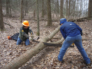
Monday, August 10, 2009: BMT Section 18a - Cold Springs Gap to Cherry Log Gap. I really appreciate the help that I had working on my section of the Benton MacKaye Trail yesterday. We parked at Cold Springs Gap and then hiked in about 2 ¼ miles to the site of the single tree that needed clearing on this section. As you can see from the attached picture (courtesy of Ed Ley), we had some problems getting the plastic wedges to stay in the kerf. Shortly after this picture was taken, we got the saw stuck, then had to work with the wedges to get it out. After we cleared this stubborn tree, we brushed out 1 ¼ miles of the trail (running sling blades for every foot of trail) from the intersection with Bob Stratton Alternate back to the intersection with the Cold Springs Gap Trail.
Here are our hours for the work trip:
Name
Travel Hours
Work Hours
Totals
Ken Jones
1.5
8
9.5
Tazz Reid
1
8
9
Ed Ley
3
9
12
Totals
5.5
25
30.5
Thursday, October 1, 2009: BMT Section 18a - Fodderstack Trail. We started work yesterday on fixing a problem spot on Fodderstack. This spot requires hikers and horse riders to go above a large tree, and then drop steeply down about 3 feet over roots. It is located on the side of Rockstack about 4 ¼ miles in from Cold Springs Gap. We made a start on digging in a new route just below the large tree. We had to find a ledge across a large rock and build up rock cribbing for every foot of new trail dug. We completed about 20’ of new trail which represents the hardest half of the work required. I believe that we can complete the remaining work with one more work day.
Here is our time for this trip:
Name
Travel Hours
Work Hours
Totals
Ken Jones
3.5
6.5
10
Tazz Reid
3
6.5
9.5
Totals
6.5
13
19.5
October 16, 2009: BMT Section 18a. We had a great work crew to continue our task of fixing a problem spot on Fodderstack Trail. The problem was a steep drop over tree roots on the side of Rockstack, dangerous for horse riders and hikers alike. We started the 4 ¼ mile hike in from Cold Springs in the light rain, and it continued on us for most of the day. It was lunch time when we reached the work site, so we broke for lunch before starting work. We dug about another 40’ of new trail to complete the realignment. The new tread is on grade, but on a steep side slope requiring a lot of rock cribbing. We ran into one problem in the middle of the route when Blue struck water in a previously unknown wet weather spring. We ended up building in rock tread over the seep spring. We doubt that any water will flow from the spring except in the very wettest of conditions. The new trail alignment looks very good and hopefully will be safer as well as require minimum maintenance.
Here is our volunteer time for the day:
Name
Travel Hours
Work Hours
Totals
Ken Jones
1.5
8
9.5
Tazz Reid
1
8
9
Bobby Mitchell
1.5
8
9.5
Carey McHugh
1.5
8
9.5
Blue Goodsen
1.5
8
9.5
Totals
7
40
47
Tuesday, January 19, 2010: BMT Section 18a - Fodderstack Trail -We had warmer temperatures, but still some lingering ice in the shady spots for our work trip today. We logged out the road section of Fodderstack from Beech Gap to Cold Springs Gap. I didn’t count the trees cleared, but I would guess about a dozen and a half, including the one Greg Kirkland (USFS Tellico Ranger District Trails Tech) cut in the 24” range. We made it to Cold Springs Gap at lunch time. After lunch we cleared 3 additional trees inside the wilderness section with axe and small saws.
We enjoyed working with you and Mary Jane for this trip. Here are the volunteer hours:
Name
Travel Hours
Work Hours
Totals
Ken Jones
1.5
6
7.5
Rick Harris
1
6
7
Ed Ley
3
6
9
Totals
5.5
18
23.5
Friday, January 22, 2010: BMT Section 18a - Fodderstack Trail - Our work trip scheduled for this past Thursday was cancelled due to the bad weather. Some of us got together on Friday to continue this work trip thinking that the weather would be better. We worked in the fog and drizzle all day, so it was only marginally better! We went in to Cold Springs Gap and started working our way north on Fodderstack clearing blowdowns and lots of small limbs and tops. We cleared about 1 ¾ miles of the trail to the stream crossing of an upper tributary of the North Fork Citico. For the day we cleared 14 blowdowns with the crosscut saw and axe. From previous hiker reports, this was the majority of the work north bound all the way to the Crowder Place.
Here are our volunteer hours for the day:
Name
Travel Hours
Work Hours
Totals
Ken Jones
1.5
7.5
9
Tazz Reid
1
7.5
8.5
Blue Goodsen
2
7.5
9.5
Totals
4.5
22.5
27
Thursday, January 28, 2010: BMT Section 18b - Fodderstack Trail - We had a large crew of 9 that showed up for the work trip today. Three of the workers decided to log out BMT Section 17d from Beech Gap to Mud Gap. This section belongs to the Cheoah District of the Nantahala National Forest, so a separate report will be provided to the proper Forest Service personnel. The remaining 6 workers started in from Farr Gap logging out Fodderstack Trail. We cleared 14 trees from there to the Crowder Place. At that point we split into 2 groups, with one group going down Crowder Branch and the other continuing on Fodderstack and going down Mill Branch Trail. Crowder Branch was still clear of blowdowns. One large locust was cleared from Mill Branch Trail. One additional tree was cleared from Fodderstack Trail between Crowder Branch and Big Stack Gap.
It turned out to be a very nice day for the work trip, and all were treated to some great winter views of Gregory Bald, Hangover, and Calderwood Dam. Here are the volunteer hours for this work trip:
Name
Travel Hours
Work Hours
Totals
Ken Jones
1.5
8.5
10
Tazz Reid
1
8.5
9.5
Bill Hodge
1
8.5
9.5
Ed Ley
3
8.5
11.5
Blue Goodson
2
8.5
10.5
Bobby Mitchell
2
8.5
10.5
Totals
10.5
51
61.5
Thursday, February 11, 2010: Rocky Flats Trail - When we gathered at the Ranger Station yesterday, conditions looked good for the work trip since there was no snow at all. We knew there was snow at the higher elevations, so we changed the work trip plans from Fodderstack Trail to a low elevation trail, Rocky Flats. As we drove toward Warden Fields, we started to see snow on the ground and then on the Cherohala Skyway. By the time we made the turn off toward Indian Boundary, everyone had to shift to 4WD. When we met up with the others at Warden Fields, there was 2” – 3 “of snow on the ground. The decision was made that it would not be safe to attempt to log out the trail in those conditions, so the trip was cancelled.
Some of us decided to drive up on the Skyway just for recreation and to enjoy the scenery. We found snow over a foot deep with wind blown drifts much over 2’ deep. We drove over to Robbinsville for lunch and returned the same way back to Tellico. By the time we drove back the snow plows had been through and the road conditions were better.
As we have discussed, I have included the travel time for each volunteer to and from the Ranger Station, and an additional 2 hours work time for the cancelled trip as follows:
Name
Travel Time
Work Time
Totals
Ken Jones
1.5
2
3.5
Tazz Reid
1
2
3
Ed Ley
3
2
5
Rick Harris
0.5
2
2.5
Bill Hodge
1
2
3
Bobby Mitchell
1.5
2
3.5
Blue Goodson
2
2
4
Larry Dodd
1
2
3
Totals
11.5
16
27.5
Monday, April 5, 2010 - BMT Section 18a - Rick Harris and Ken Jones logged out 3 large trees and several smaller trees and limbs from the trail between Beech Gap and Cold Springs Gap with chain saw. Here are the volunteer hours:
Name
Travel Hours
Work Hours
Totals
Ken Jones
1.5
2
3.5
Rick Harris
1
2
3
Totals
2,5
4
6.5
Thursday, April 16, 2010 - BMT Section 18a - Two crews took on finishing the Fodderstack Trail. Mission accomplished! The final stretch to be cleared (top of the Pine Ridge Trail to Cherry Log Gap), was completed on this trip. Tazz and Ed worked in from Cold Spring Gap with Bobby, Blue and myself working up the Pine Ridge Trail. The two crews met just above Harrison Gap and hiked out via Pine Ridge.
Here are the hours:
Name
Travel Hours
Work Hours
Totals
Tazz Reid
1
8.5
9.5
Bill Hodge
1
8.5
9.5
Ed Ley
3
8.5
11.5
Blue Goodson
1.5
8.5
10.0
Bobby Mitchell
1.5
8.5
10.0
Totals
8
42.5
50.5
Monday, July 19, 2010: BMT Section 18a - Fodderstack Trail - It was raining hard again this morning, so we called Bobby Mitchell and cancelled his bush hog work for the day. By the time that Tazz reached the Ranger Station the rain had stopped, so we decided to drive up the Skyway and do what we could on the overhanging limbs. On the way up we stopped at the upper Long Branch Trailhead to look at the trail. It turned out to be more look for the trail, with weedeaters in hand. We finally found one tree with a blaze several hundred feet in from the parking spot, and cleared to this tree. This will at least give us a start on finding the trail with the chainsaws on Thursday. We went on up to Beech Gap and used the weedeaters to cut the overhanging limbs to Cold Springs Gap. This work will make it easier for Bobby to mow the road at a later time.
Here are our hours for the work trip:
Name
Travel Hours
Work Hours
Totals
Ken Jones
1.5
5
6.5
Tazz Reid
1
5
6
Totals
2.5
10
12.5
Monday, July 26, 2010: BMT Section 18a - Fodderstack Trail - Bobby Mitchell was kind enough to bring his tractor to mow the trail (gated road) from Beech Gap to Cold Springs Gap today. He mowed all the way to Cold Springs Gap without any problems. When we reached the gap we found a tent set up. It belonged to TiPi Walter and his dog who were finishing up a 16 day backpacking trip in the wilderness. After he broke camp, Bobby finished mowing the gap and turned around mowing back to Beech Gap. Along the way he broke a shear pin and found the gear box loose. After finishing to Beech Gap and backing the trailer to load the tractor, he found the wire broke that supplies trailer lights, and more importantly electric brakes. We ate lunch in the gap and then started slowly down the Skyway. Bobby made it down without any problems other than some hot truck brakes. The area that Bobby mowed really looks good and should last until the first freeze at the high elevations. I spent my time for the day clearing limbs out of the trail.
Here are our volunteer hours for the day:
Name
Travel Hours
Work Hours
Totals
Ken Jones
1.5
4
5.5
Bobby Mitchell
1.5
4
5.5
Totals
3
8
11
Tuesday, August 3, 2010: BMT Section 18b - Fodderstack Trail - Jeff Hunter and I brushed out the Fodderstack Trail south bound to a point just above the Crowder Branch Trail junction. There were a couple of heavy green brier patches, otherwise just the usual annual growth. We hiked on to and down Mill Branch Trail which is actually is pretty decent shape. The Fodderstack Trail past where we stopped was in good shape to the Mill Branch Trail junction, though I want to return and finish brushing it out to the Pine Ridge Trail junction. Here are the hours:
Name
Travel Hours
Work Hours
Totals
Bill Hodge
1
9
10
Jeff Hunter
3.5
9
12.5
Totals
4.5
18
22.5
Friday, October 1, 2010: BMT Section 18a - Fodderstack Trail - Bill Hodge and Ken Jones had the privilege of working with 7 of the ladies from the Great Old Broads for Wilderness on Fodderstack Trail last Friday. They went in from Cold Springs Gap and began work at the first uphill past the Cold Springs Gap Trail intersection with Fodderstack. They cleaned out a long ditch and dug two water turnouts into this ditch. They also did 4 other water diversions for the day and de-burmed the trail all the way to the first stream crossing of a North Fork Citico tributary. This should put this segment of the trail back in good shape for erosion control. Here are the hours for this work trip:
Name
Travel Hours
Work Hours
Totals
Ken Jones
1.5
6
7.5
Bill Hodge
1
6
7
Wilderness Ladies (x 7)
1x7=7
6x7=42
49
Totals
9.5
54
63.5
Tuesday, October 12, 2010: BMT Section 18a - Fodderstack Trail - We worked on some specific problems on the southern portion of the Fodderstack Trail. We started by walking in about 3.5 miles from Cold Springs Gap and cleared a briar patch. We then worked our way back about 2 miles to clear a 16" fire cherry from the trail. Along the way we cleared the bad spots of weeds and briars. We cut back some Rhododendron that was closing in on the trail corridor. We also cleared a few smaller trees that were across the trail. Here is our volunteer time for this work trip:
Name
Travel Hours
Work Hours
Totals
Ken Jones
1.5
8.5
10
Rick Harris
.5
8.5
9
Totals
2
17
19
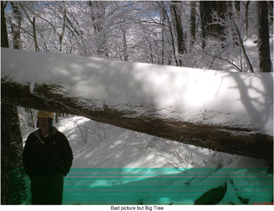
Thursday, March 3, 2011: BMT Section 18b - Fodderstack Trail - While the rest of the crew re-flagged the proposed horse trails Roger Taylor and Bill Hodge logged out 4.5 miles of the Fodderstack/Benton MacKaye Trail. They worked from Farr Gap to the top of the Mill Branch Trail, and then hiked out the Mill Branch Trail. They cleared about 14 trees from the trail and a bunch of small stuff as well. The only down part of the day was discovering what is believed to be the largest tree in the Citico Creek Wilderness came down this winter. The Mill Branch Trail will need some attention. Hours;
Bill Hodge - 1 hour travel - 8.5 hours work - 9.5 hours total
Roger Taylor - 1 hour travel - 8.5 hours work - 9.5 hours totalMonday, October 10, 2011 - BMT Section 18b - Fodderstack Trail - The AHS Volunteer Vacation Crew and several BMTA volunteers logged out the few trees on this section of the BMT and repaired a dozen or so water bars and water diversions. We entered via Farr Gap and exited on the Crowder Branch Trail. Most of the water bar work was done on the final stretch of trail just before reaching the Crowder Branch Trail.
Name
Travel Hours
Work Hours
Totals
Rick Harris
0.5
7.5
8
Ken Jones
1.5
7.5
9
Bobby Mitchell
1.5
7.5
9
Joanne Mitchell
1.5
7.5
9
Richard Sullivan
3.5
7.5
11
Rick Foster 1.0 7.5 8.5 Eric Randall - VV 7.5 7.5 Mark Harrold - VV 7.5 7.5 Sarah Slover - VV 7.5 7.5 Betty Gill - VV 7.5 7.5 John Carmichael - VV 7.5 7.5 Tina Stambaugh - VV 7.5 7.5 Tina Temple - VV 7.5 7.5 Bill Twitty - VV 7.5 7.5 Totals
9.5
105
124.5
Sunday, February 26, 2012 - BMT Section 18b - Fodderstack Trail from Farr Gap to Pine Ridge Trail - Five of us met behind the Cherohala Skyway Visitor Center in Tellico Plains at 8 AM, then drove to Warden Fields, dropping off two vehicles there, then continued to Farr Gap in the other two vehicles. We did a thorough job of logging and brushing out the BMT from Farr Gap to the Pine Ridge Trail, a distance of 5.3 miles with significant ups and downs. We cut with crosscut saw about a dozen trees and pulled off many more smaller trees and logs from the trail. We ate lunch at the Crowder Branch Trail intersection, rested at the Mill Branch then headed up the long climb up Big Fodderstack and the intersection with the Pine Ridge Trail. Most of the big trees to remove were from the Mill Branch Trailhead to the Pine Ridge Trail intersection. This is the section that has not been logged out in quite some time. The trail is now completely clear of blowdowns and is nicely brushed out. We then rested a while, then hiked out on the Pine Ridge Trail, which has several blowdowns, especially two very large and complex ones within the last mile which would totally prevent horse traffic. Also, the Pine Ridge Trail needs brushing out near the top and just uphill from where the trail switches from the south to the north side of the ridge. Afterwards, we all went to eat pasta at the Tellicafe.
Name
Travel Hours
Work Hours
Totals
Rick Harris
0.5
11
11.5
Bill Lundin
3
11
14
Rick Foster
0.5
11
11.5
Zoey Zardis
1
11
12
John Zardis
1
11
12
Totals
6
55
61
Saturday, April 28, 2012 - BMT Section 18a - Fodderstack - Phyllis and I had a chance to walk all of my section of Fodderstack last Saturday. We left one vehicle at Warden Fields and drove to Beech Gap to begin our hike. I took an axe with me to clear small trees and a folding saw to clear broken down Rhododendron from the trail. The road from Beech Gap to Cold Springs Gap was clear of any blowdowns. For the 7.9 miles from Beech Gap to the Pine Ridge Trail intersection I probably cleared about a dozen smaller trees from the trail. There were 11 trees larger than 6" that were across the trail between Cold Springs Gap and Harrison Gap that will require a crosscut saw at a later date. I recorded the sizes and GPS coordinates but am having trouble getting my GPS and computer together in the same state with my recent move to Georgia. Here is the data that I recorded:
GPS Waypoint location #
Tree Size Across Trail
060
12" and 8"
061
8" and 10" pin cherry
062
10"
063
18"
064
Multiple 12" forks lengthwise in trail
065
6" and 4" top
066
8" locust
067
12" one cut to clear
068
16" two cut
I can send a map at a later date but Rick Foster has reported on these same locations in his walkthrough report. All of these trees are easy for hikers to get through. Also note that trees on the ground and less than a 14" step over are within wilderness standards and are not reported. Horse riders are having a problem with 2 of these trees and are creating a ride around for one and the other will require a ride around when the next rider comes through. Even given the horse difficulties on getting through, I believe the worst problem are briars in the trail between Cherry Log Gap and Glen Gap. They are really bad and the growing season has not even started. My priority will be to brush out this segment on our next work trip. The entire trail will need brushing our this summer and we will make an effort to accomplish that feat. Here are our volunteer hours for this trip:
Name
Travel Hours
Work Hours
Totals
Ken Jones
2.5
8
10.5
Phyllis Jones
2.5
8
10.5
Totals
5
16
21
Saturday, July 7, 2012 - BMT Section 18a - Beech Gap to Pine Ridge Trail Intersection - Five maintainers drove to Beech Gap on the Cherohala Skyway, then up the closed FS road to Cold Springs Gap. From there, the 5 logged and brushed out the Fodderstack section of the BMT out almost to Cherry Log Gap. There was a lot of brushing out needed on this section. The maintainers then returned to there vehicles at Cold Springs Gap and returned to Tellico Plains. The day was quite hot and the maintainers were quite bushed by the end of the day. At a later date, we will go back and finish the job the rest of the way to the Pine Ridge Trail intersection. Some of us ended up at the Outpost afterwards for beer and pizza and calzones.
Name
Travel Hours
Work Hours
Totals
Ken Jones
1.5
8.5
10
Phyllis Jones
1.5 8.5 10 Larry Dunn
2 8.5 10.5 Roger Taylor 1.5 8.5 10 Ed Ley
3
8.5
11.5
Totals
9.5
42.5
52
Friday, Aug 31-Saturday Sept 1, 2012 - BMT Sections 18b-19a - Fodderstack/Stiffknee Sections - Friday and Saturday a crew from SAWS did some work in the Joyce Kilmer-Slickrock / Citico Creek Wilderness complex. We logged out the Fodderstack/Benton MacKaye trail from Farr Gap to the top of Big Stack Gap Branch trail (seven trees). We also did some brushing in this section, though it could use another trip with slingblades. We did brush back the worst sections, and in general this section of trail is in pretty good condition. We also took two trees off of the Stiffknee/Benton MacKaye trail near Farr Gap. We had a beautiful night camping at the old Crowder Place. We provided 45 hours of work and travel time to this project. SAWS Ranger Peter Reber will try and spend some time on the brushing needed on the Slickrock Creek trail between Stiffknee and Big Stack Gap Branch trails.
Contact the Webmaster