
Cherokee Hiking Club
198 Crews Drive, Benton, TN 37307
Trail
Maintenance
Starr
Mountain Horse Trails
Saturday, March 21, 2009
July 15, 2009
July 21, 2009
July 24, 2009
July 28, 2009
August 6, 2009
August 10, 2009
Thursday, Feb 2, 2012
Thursday, Feb 9, 2012
The Starr Mountain Horse Trail system is on Starr Mountain and adjoining Chestnut Mountain. The trails for the most part follow old forest service and logging roads. Some trails follow ridgelines and others follow along the creeks in the area. A horse camp is available along at the south end of Starr Mountain along the Hiwassee River (Lost Corral Campground).
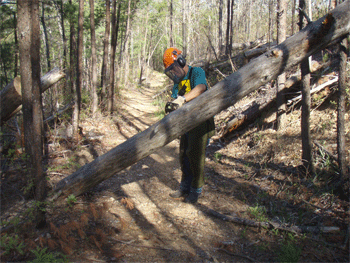
Saturday, March 21, 2009: Rick Harris had recently hiked the Coffee Branch/Chestnut Mtn Loop, and he had reported trees down. Tazz Reid cleared out Coffee Branch Trail down to Lost Corral on Saturday, for the second time this year. He last cleared it in January. That loop out of the horse camp is clear again. He met 7 horses on the trail and there were 3 campsites occupied at the horse camp.
There was a huge Virginia Pine that had fallen with its root ball between the cliff and Iron Gap. There was also a very large oak just barely out of site of Lost Corral. He got his saw stuck in that one and had to chop it out with my hatchet.
He cut a total of 3 trees and several small things that he ran over/threw out of the road. Maybe that will get it for this year.
2.5 hours work + 1 hour travel time= 3.5 total hoursStarr Mountain Trail 190 Section in the Gee Creek Wilderness
July 15, 2009: Worked mowing and lopping starting on the north end of the trail.
Name
Travel Hours
Work Hours
Totals
Ron Allen 2.5 4.5 7 Robert Owenby 3 4.5 7.5 Clayton Pannell 2 4.5 6.5 Totals
7.5 13.5 21 Note: Brush Ax is no good in clearing most trails it leaves to many sharp stubs and a lot to do with the loppers
July 21, 2009: Worked sawing out blow downs, with cross-cut and ax. Cut 14 trees out of the trail and rolled 2 logs out of the trail. All trees counted were over 6”
Name
Travel Hours
Work Hours
Totals
Ron Allen 2.5 5.5 8 Robert Owenby 3 5.5 8.5 Clayton Pannell 2 5.5 7.5 Totals
7.5 16.5 24 July 24, 2009: Worked with mowing scythe and loppers clearing trail
Name
Travel Hours
Work Hours
Totals
Clayton Pannell 2 6 8 Totals
2 6 8 July 28, 2009: Worked sawing out the reminder of the trail in the wilderness, did not get a count on trees
Name
Travel Hours
Work Hours
Totals
Cathy Allen 3 5 8 Robert Owenby 3 5 8 Clayton Pannell 2 5 7 Totals
8 15 23 Aug 6, 2009: Worked in wilderness cutting brush and lopping
Name
Travel Hours
Work Hours
Totals
Clayton Pannell 2 5.5 7.5 Totals
2 5.5 7.5 Aug 10, 2009: Worked cutting brush and lopping, with a scythe, sling blade and lopper
Name
Travel Hours
Work Hours
Totals
Robert Owenby 3 6 9 Clayton Pannell 2 6 8 Totals
5 12 17 This completes the wilderness work on the Starr Mt. We did leave some blowdowns that are not over 12” high to step over.
Note: There is still one blow down left behind after we sawed the trail out but one can step over it about knee highHours total for each worker on the Gee Creek wilderness section of Starr Mtn Trail #190
Name
Travel Hours
Work Hours
Totals
Ron Allen 5 10 15 Cathy Allen 3 5 8 Robert Owenby 12 21 33 Clayton Pannell 12 32.5 44.5 Totals
32 68.5 100.5 Early Feb, 2012 - Starr Mtn Trail #190 - Clayton and Robert logged out the Starr Mtn Trail completely over three separate work days in late Jan and early Feb. They did not give me their work hours, but probably about 8 hours each day for 3 days for a total of 48 hours.
Thursday, Feb 2, 2012 - Starr Mountain Horse Trails - Tazz and I [Ken Jones] continued the work on routing a new horse trail that would loop around the northern end of Starr Mountain this past Thursday. Our first objective was to find the private land boundary along our previous flag line and attempt to route the line on Forest Service land. We spent over an hour looking for a property corner where the Tennessee Property Viewer on the internet showed the location. We accidentally found some red paint and then found the corner marker about 1/4 mile from where the state map said it should be, and on the opposite side of the Etowah Utilities power line road. We then flagged a route from the Cooper Gap Road up to the EU Road that was totally on FS land, but required 5 switchbacks. From the EU Road we walked up to the fire tower and explored possible routes from that point. We looped back down to the EU road and found that we could not transition up the bank to get around the private land corner. At that point we decided to abandon routing the trail on the west side of the tower and started over on the east side. We started flagging out of the wildlife clearing and proceeded to a gap just north of the tower. We crossed through this gap and set a 10% down grade to work our way to the previous flag line. In order to tie into the gap at the end of the previous flag line required 7 switchbacks with little distance between. Although this is bad for sustainability, it seemed to be our only option. We continued northeast by flagging along the old road. Please refer to the attached map that shows the trail that was flagged for the day in purple. We also ran into another possible problem regarding the private land parcel known locally as the "chicken ranch". We had thought that we could bypass this 7 acre parcel to the west and along the brow of the mountain. While walking in this area, we found 3 trees with red paint that seemed to possibly indicate that the private land parcel may extend west to the brow of the mountain. We will have to spend some additional time on our next trip determining how the property lines actually run to be able to flag around the boundary. Matt - if you can help us this Thursday, we could use a copy of the topographical map that shows the private land boundaries. I have also almost exhausted my own private supply of flagging ribbon, and could use about 4 - 6 rolls of blue tape from the Forest Service. Here are our volunteer hours for the work trip:
Name
Travel Hours
Work Hours
Totals
Ken Jones 2 8.5 10.5 Tazz Reid 1 8.5 9.5 Totals
3 17 20 Map of Starr Mtn Horse Trail Extension
Thursday, Feb 9, 2012 - Starr Mtn Horse Trails - Tazz and I continued our flagging of the proposed new horse trail this past Thursday. I have included a map that shows the flagging that we have accomplished. We were able to flag around the private property thanks to Tazz's work last Monday. It was easy to see the property line where he tied orange flagging around the red paint trees. We also located the other pertinent corner marker, so it made our work much easier. Matt, thanks for helping us flag the route from the wildlife clearing to the northernmost point. There is also a fabulous view spot just below the flag line on a rock promontory that is shown on the map. Here are our volunteer hours for the day:
Name
Travel Hours
Work Hours
Totals
Ken Jones 2 8 10 Tazz Reid 1 8 9 Totals
3 16 19 Thursday, Feb 16, 2012 - Starr Mtn Horse Trails - We [Ken Jones, Tazz Reid] continued our routing and flagging efforts on Starr Mountain yesterday. We began routing where we left off last Thursday, and completed flagging a route that made the tie into the Bullet Creek Spur Trail. This section of flag lie was 1.3 miles long. The entire flag line for this project is currently 5 miles long. I have attached a map that shows the route (show in Red) currently flagged for the project. The weather did not cooperate with our work yesterday. In addition to the rain we had very dense fog that made it hard to see the terrain ahead. We also had to cross some steep side drainages near the Bullet Creek Spur Trail. These drainages required finding a crossing point, then taking down flagging already placed in order to make a proper connection to the crossing point. Here are our volunteer hours for the work day:
Name
Travel Hours
Work Hours
Totals
Ken Jones 2 4 6 Tazz Reid 1 4 5 Totals
3 8 11 Thursday, Feb 23, 2012 - Starr Mtn Horse Trails - Tazz and I [Ken Jones] continued our layout and flagging of the proposed new horse trail on Starr Mountain last Thursday. We began just across the road from the Bullet Creek Spur Trail and continued along the eastern brow of the mountain to tie into the wildlife road 220C about 100 yards behind the gate. I have attached a map showing our work for the day with the flag line in red. This new segment of flag line maps at 1.8 miles in length. Also of note is a marked view spot at a rock overlook. The portion of the wildlife road 220C to be used as a trail segment is show in green and about 0.2 mile long. I have also drawn in a planned target route shown in purple for our flagging trip planned for next Thursday. We were able to scout a portion of this route last Thursday afternoon and establish two gaps that will serve as control points. Here are our volunteer hours for the work day:
Name
Travel Hours
Work Hours
Totals
Ken Jones 2 7 9 Tazz Reid 1 7 8 Totals
3 14 16 New map of Horse Trail Extension
Thursday, March 1, 2012 - Starr Mtn Horse Trails - We were able to complete our routing and flagging project yesterday. The final leg of the flagging is about 1.5 miles in length and uses another 0.1 mile of wildlife road and clearing. I have attached a map showing the final leg of the proposed new horse trail just to the east and south of Black Mountain. We were also able to route the trail through some significant rock features as labeled on the map. These huge rocks will make for an interesting ride or hike when the trail is completed. We were also able to flag the segment from the Basin Creek Road to tie into the Hogback Spur Trail. We found that the gate (H45) for the Wildlife Road near Bullet Creek was missing a lock on one end. This is the gate where recent work was done to block vehicle access around the end of the gate. I placed a new Forest Service lock on the gate to secure it. Rusty Humbert had given me several FS Locks for just such occasions out at Tellico Ranger District. We saw and heard 3 - 4 dozen Sandhill Cranes that were circling Starr Mountain yesterday afternoon. Here are the volunteer hours for our work trip:
Name
Travel Hours
Work Hours
Totals
Ken Jones 2 8 10 Tazz Reid 1 8 9 Totals
3 16 19
Contact the Webmaster