
Cherokee Hiking Club
198 Crews Drive, Benton, TN 37307
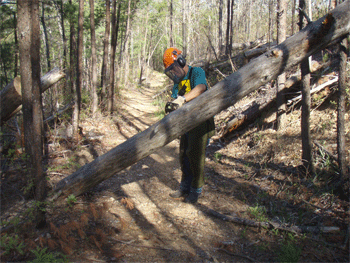
Trail Maintenance
New Horse Trail Map 1
New Horse Trail Map 2
Miller Ridge Horse Trail Map
Little Citico Horse Trails
Thursday, April 24, 2008
Thursday, June 12, 2008
Thursday, July 17, 2008
Monday, July 21, 2008
Thursday, July 24, 2008
Monday, July 28, 2008
Thursday, July 31, 2008
Monday, August 11, 2008
Thursday, August 14, 2008
Thursday, August 21, 2008
Monday, August 25, 2008
Thursday, September 4, 2008
Thursday, September 11, 2008
Wednesday, February 18, 2009
Thursday, March 12, 2009
Friday, March 20, 2009
Wednesday, August 12, 2009
Wednesday, August 26, 2009
Tuesday, September 8, 2009
Thursday, October 15, 2009
Thursday, December 10, 2009
Thursday, February 4, 2010
Thursday, October 21, 2010
Thursday, December 9, 2010
Thursday, March 4, 2011
Thursday, March 10, 2011
Monday, March 21, 2011
Thursday, March 31, 2011
Thursday, April 7, 2011
Thursday, April 14, 2011
Thursday, April 28, 2011
Thursday, May 5, 2011
Thursday, May 12, 2011
Thursday, June 2, 2011
Thursday, June 30, 2011
August 8, 2011
Thursday, January 5, 2012
Thursday, January 26, 2012
The Little Citico Creek Horse Trail system is in the Citico Creek Wilderness of the Cherokee National Forest in the drainage of Little Citico Creek. The trails for the most part follow old forest service and logging roads. Some trails follow ridgelines and others follow along the creeks in the area. A horse camp is available along the Citico Creek Road (Jake Best) and a large parking area is found where Little Citico Creek enters the main Citico Creek, accessed by a bridge over Citico Creek.
Thursday, April 24, 2008: Ken Jones, Rick Harris and Tazz Reid worked on clearing blowdowns on the Little Citico Horse Trails yesterday. Tazz had seen some blowdowns on Trail #4 when he rode it about a month ago. He had also received a report from another horse rider that a big blowdown was blocking Trail #2 near the upstream intersection with Trail #3. They drove to the end of the right fork of Bivens Branch Road and walked down Trail #3 to Little Citico. They then walked upstream on Trail #2 about ¼ miles, turned around and walked about ½ mile downstream and never found the blowdown. For this trip in, they sawed 3 smaller trees off the trail, and Rick Harris cleared a lot of small stuff from the trail. They then covered almost the entire length of Trail #4 with the chainsaws, only clearing small stuff and 4 more small trees. It turns out that someone had already cleared the trees that Tazz spotted from his previous trip.
Name
Travel Hours
Work Hours
Totals
Ken Jones
3
5
8
Tazz Reid
3
5
8
Rick Harris
2
5
7
Total
8
15
23
Thursday, June 12, 2008: Rick and I worked on brushing out Little Citico Trail #2 yesterday. We started at the trailhead just across the bridge, and worked from there upstream on Little Citico Creek. We completed brushing out and mowing 1.2 miles of the trail. About 2:15 pm it started to rain on us, and rained hard for about 30 minutes as we walked back to the truck. We were hot enough that the rain felt great at the end of a work day.
Here is our volunteer time for the day:
Name
Travel Hours
Work Hours
Totals
Ken Jones
1.5
6
7.5
Rick Harris
1
6
7
Totals
2.5
12
14.5
Thursday, July 17, 2008: Tazz and I continued working on re-flagging the new horse trails in preparation for the botanical survey. Today we worked on a 3.2 mile segment of the Salt Spring Mountain Trail. We again found a number of flags on the ground, but I would guess less than 1/3 of the total hung on the route last fall. Again we saw evidence of a lot of bear activity along the flag line, and found bear scat with pieces of blue flagging in it. We saw dozens of trees that had fresh scratches on the bark, with one place being about 7’ high. We re-flagged this entire route, and it is now in good shape for the botanist to make their way through.
I almost stepped on a fawn hiding in the thick brush. It was so young that it could not get up on all fours to run, and was only able to move slowly away from us.
Here is our time for the trip:
Name
Travel Hours
Work Hours
Totals
Ken Jones
2.5
5.5
8
Tazz Reid
2.5
5.5
8
Totals
5
11
16
Monday, July 21, 2008: I continued working today on re-flagging the new horse trails in preparation for the botanical survey next month. I started at Farr Gap this morning and worked my way to the un-named gap very near Webb Gap. I flagged the entire old Milligan Creek Road, heavy at the intersections and sparse where there is no where else for a botanist to go. We have one short section that is flagged off the old road through a dead pine ridge. There were very few of the original flags on the ground, but the vicious summer growth managed to hide many of the hanging flags. At one point I went astray down a spur ridge, then had to backtrack and remove about 5 – 6 flags. I hung flagging so that you can always see at least one flag ahead.
The heat was brutal today, nearing 100 degrees with high humidity. The climb back to Farr Gap in the afternoon was the hardest thing I have ever done on a trail. I saw a hog on the skyway near mile 11 this morning. I also saw a deer upslope as I headed down from Farr Gap.
Here is my time for the day:
Travel Hours = 3 Work Hours = 6 Total Hours = 9
Thursday, July 24, 2008: We continued working on re-flagging the new trail routes today in preparation for the botanical survey next month. We had four of us, so we split into 2 teams and covered another 5 miles of the Milligan Branch Trail. We drove around the Mountain Settlement Road to the gate on Jake’s Creek. From there we all hiked in about ¾ mile up the creek to intersect the flag line. Jim and I made our way back toward Little Citico Trail #2, while Tazz and Bobby made their way toward Webb Gap. With this method, we were able to cover 5 more miles. Together with the 2.5 miles I did on Monday, we completed this entire route from Farr Gap to Little Citico #2.
Here are our volunteer hours for the work trip:
Name
Travel Hours
Work Hours
Totals
Ken Jones
3.5
5
8.5
Tazz Reid
3.5
5
8.5
Jim Holland
4
5
9
Bobby Mitchell
3.5
5
8.5
Totals
14.5
20
34.5
Monday, July 28, 2008: We continued our work on walking and re-flagging all of the new trail routes in preparation for the botanical survey. We had two teams, so we were able to split up again and cover a lot of ground. One team started at Cold Spring Knob and walked the new trail route on Cowcamp Lead all the way down to Doublecamp near Mill Branch. The other team covered the flag line from the Gold Cabin Branch Road to the Bivens Branch Road. After that both teams eventually met back up at Cold Spring Knob to complete 0.4 miles on the south and east side of the knob. The only remaining flag line that has not been recently reworked is about 1 1/3 miles long, and runs to Farr Gap just off the vehicle road.
Here are the volunteer hours for the trip:
Name
Travel Hours
Work Hours
Totals
Ken Jones
3
6
9
Tazz Reid
3
6
9
Bobby Mitchell
3
6
9
Rick Harris
1.5
5
6.5
Totals
10.5
23
33.5
Thursday, July 31, 2008: The SABCH had a maintenance trip on the Little Citico Horse Trails last Thursday. I want to especially thank Tazz Reid for the work report, and Matt Henry for leading this trip in my absence. Everyone split up into three work crews, and worked in different areas to brush out as much trail as possible with weedeaters. One group completed all of Trail #1 (1.5 miles), another group worked on the eastern end of Trail #4 (3/4 miles), while the last group worked the western ends of Trails #3 and #4 above Citico Creek (3/4 miles). This work trip completed a big portion of all of the trails, and we should be able to complete the remainder for this Fiscal Year’s targets.
Here are the volunteer hours for the trip:
Name
Travel Hours
Work Hours
Totals
Tazz Reid
2
6
8
Roy Hutsell
2
6
8
Jennifer Hutsell
2
6
8
Phil Hadorn
2
6
8
Janice Butt 2 3 5 Arlin Phillips 1 6 7 Totals
11
33
44
Monday, August 11, 2008: Matt and I continued brushing out the Little Citico Horse Trails yesterday. We started on the western portion of Trail #3, and worked from the #4 intersection up to the end of the Left Fork of the Bivens Branch Road. From there we drove to the gate at the end of the Little Citico Road on Trail #2. We started work at the gate and spent the rest of the day working in the tall weeds through the old timber sale area. I estimate that we brushed out 0.5 miles on Trail #3 and 0.2 miles of Trail #2.
It was a great work trip since neither of us got any yellow jacket stings.
Here is my time for the trip:
Travel Hours = 3 Work Hours = 5 Total = 8 hours
Thursday, August 14, 2008: We continued our work on brushing out Trail #2 today. We started behind the gate where Matt and I finished up last Monday. I estimate that we brushed out about 2 miles of trail for the day. The work today completed brushing out this entire trail during the summer. We lack about 1.5 miles more on Trail #3 and #4 to complete brushing out all of the Little Citico Horse Trails for the growing season.
Here is our volunteer time for the work trip:
Name
Travel Hours
Work Hours
Totals
Ken Jones
2.5
6
8.5
Tazz Reid
2.5
6
8.5
Bobby Mitchell
3
6
9
Joann Mitchell
3
6
9
Totals
11
24
35
Thursday, August 21, 2008: Tazz Reid sent me this work trip report for last Thursday. They completed brushing out the remainder of Trail #4 along Bear Branch and about 400’ down Citico Creek. I estimate the amount of trail brushed out to be 1 mile.
Tazz got to see a lot of wildlife for the day totaling up with 1 bear, 3 hogs, 1 rabbit, and 2 coyotes. Luckily the coyotes were a long way from the rabbit.
Here is their volunteer time for the work trip:
Name
Travel Hours
Work Hours
Totals
Tazz Reid
3
5
8
Arlin Phillips
3
5
8
Totals
6
10
16
Monday, August 25, 2008: I continued working on brushing out the last remaining segment of Trail #3 today. I parked at the end of the Bivens Branch Road, Right Fork, and headed down toward Little Citico Creek with chainsaw and weedeater. I dropped off the weedeater about ½ mile in, then hauled the chainsaw another 1/3 mile to saw one tree blocking the trail. After that I walked back up the hill to the weedeater and started brushing out back toward my truck. I completed the ½ mile of brushing out for the day.
The work today completes brushing out all of the Little Citico Horse Trails (thanks to Southern Appalachian Backcountry Horsemen, Rick Harris, and Matt Henry). Together with logging out all of the blowdowns twice this year, and Rusty’s contractor mowing the wildlife road portions, we have completed 15 miles of trail maintained to standards. This also completes meeting the trail targets for the Fiscal Year, bringing the totals to 25.8 miles for the year.
Here is my volunteer time for the day:
Travel Hours = 3.5 Work Hours = 5 Total = 8.5
Thursday, September 4, 2008: We spent the day working on the reroute just across Citico Creek from the Horse Camp. The reroute was constructed more than 10 years ago to take the trail out of a sunken road bed. The lower portion of the reroute is built on a step side slope, and was not very wide. We had received several comments from horse riders that this segment was not suitable for novice riders. We spent the day working to widen this problem spot. It turns out that the reason that the trail was not dug in wider to begin with is that much of it is across large rock. With the help of a pick, sledge hammer, and Robert Thomas, we were able to widen about half of the problem spot. We will need to spend another day with picks and rock bar to finish the work to put this segment in decent shape.
Here is our volunteer time for the day:
Name
Travel Hours
Work Hours
Totals
Ken Jones
3
4.5
7.5
Tazz Reid
3
4.5
7.5
Jim Holland
4
4.5
8.5
Totals
10
13.5
23.5
Thursday, September 11, 2008: Robert Thomas and the SABCH volunteers continued working on widening the reroute just across Citico Creek from the horse camp. They were able to finish work on the reroute by moving and breaking up a lot more rocks. This puts the reroute segment more in line with the rest of Trail #1 for difficulty, and more suitable for novice riders. After lunch they drove to the gate on the right fork of the Little Citico Road to clear a blowdown on Trail #2. They cleared the large tree as well as one smaller tree with the chainsaw.
Here are the volunteer hours for the day:
Name
Travel Hours
Work Hours
Totals
Tazz Reid
1.5
5
6.5
Arlin Phillips
1.5
5
6.5
Bobby Mitchell
2
5
7
Totals
5
15
20
Wednesday, February 18, 2009: Robert Thomas and I worked on some miscellaneous trail items close to the roads on a rainy morning. We started by clearing the only two trees remaining on the Pine Ridge Trail just inside the wilderness at Warden Fields. After clearing these, we drove to the Little Citico Trailhead across the bridge. We cleared one large tree from Trail #3 just a few hundred yards in from where we parked.
Here is my time for the day:
Travel Hours = 1.5 Work Hours = 3 Total = 4.5
Thursday, March 12, 2009: A group of volunteers worked on logging out the Little Citico Horse Trails. They completed clearing Trail #2, Trail #4, and the non-road portions of Trail #3. They removed a total of 39 trees from these trails for the day. The remaining portions of trails to be cleared are Trail #1 and the portions of Trail #3 on the Bivens Branch Road, right and left forks. We will try to complete these parts on Saturday during the trash pickup for all of the Little Citico Trails.
Here are the volunteer hours for the work trip:
Name
Travel Hours
Work Hours
Totals
Tazz Reid
1
8
9
Ed Ley
3
8
11
Rick Harris
1
8
9
Totals
5
24
29
Friday, March 20, 2009: The Mitchells worked on logging out Little Citico Horse Trail #1 today. They cleared 7 trees plus a number of other small trees from the trail.
Here is their volunteer time for the work trip:
Name
Travel Hours
Work Hours
Totals
Bobby Mitchell
2
2.5
4.5
Joanne Mitchell
2
2.5
4.5
Totals
4
5
9
August 12, 2009: We worked yesterday to fix the rock hazard on Bear Branch on the Little Citico Creek Horse Trail #165-4. We really appreciate you and Rusty getting the 6 x 6 timbers part of the way into the site on Tuesday and your hard work with us. We used the timbers as cribbing to cut a trail into the steep bank that will serve as a permanent bypass of the rock hazard on the upstream end. On the downstream end we used the existing road bank transition and marked out a flat trail route on the opposite bank from the rock hazard. This short segment takes the horses out of the spot where they have been riding in the stream bed for about 50’. The new route substitutes two stream crossings and a good trail that should hold up well.
I believe that this work can count for 0.1 mile of Trail Improvement toward the fiscal year target. Here are the volunteer hours for the work trip:
Name
Travel Hours
Work Hours
Totals
Ken Jones
1.5
7.5
9
Bobby Mitchell
1.5
7.5
9
Totals
3
15
18
Wednesday, August 26, 2009: This email serves to document our work trip logging out Little Citico Horse Trail #2. Joanne Mitchell had ridden this trail last Saturday and reported some trees down on the road portion and the single track portion along the creek. We found that the contractor had been in to mow the road and wildlife clearings this week. The contractor cleared the two trees that were down on the road, so we drove to the end of the gated road. From there we hiked down to Little Citico Creek and back downstream to the bridge trailhead. We cleared a total of 4 trees from the trail and some more small stuff along the way. There were a number of wet muddy spots along the creek, and we looked at some possibilities for relocating the trail around these areas. After returning to the Ranger Station, we did some cleaning up and preparation work for tomorrow.
Here is my time for the day:
Name
Travel Hours
Work Hours
Totals
Ken Jones
1.5
7.0
8.5
Totals
1.5
7.0
8.5
Tuesday, September 8, 2009: Little Citico Creek Horse Trails & Sycamore Creek Trail: This email documents my [Ken Jones] volunteer time for yesterday. We [Ken and Greg Kirkland] started the morning meeting with Cameron Atchley, the owner of Coker Creek Village, talking about ways that they could help on trails and other volunteer work for the District. After the meeting I drove to the upper trailhead of Sycamore Creek Trail. I installed a new carsonite post, complete with the Adopt-A-Trail decal recognizing Kent and Pam Mathews’ work on this trail. In the afternoon we went to the Horse Camp and walked the proposed new trail route from there to the proposed new parking area. About mid-way along the route we found a number of empty fertilizer bags that may indicate that someone was growing a cash crop nearby. We all need to be especially careful when we are back on this flag line in the future.
Here is my time for the day:
Name
Travel Hours
Work Hours
Totals
Ken Jones
1.5
7.5
9.0
Totals
1.5
7.5
9.0
October 15, 2009: Little Citico Horse Trails - It was raining hard this morning, so we started the day working out priorities for maintenance work for the upcoming Fiscal Year 2010. After lunch we decided to go look at the fix that we had recently made to the rock problem on Bear Branch. We wanted to see how well the reroute had stood up to the heavy rains that we have been receiving. Joanne Mitchell had also reported a tree down at the intersection of Trails #3 & #4 near Citico Creek. We cleared this blowdown (thank you for this report, Joanne) and another tree on the way in to Bear Branch. When we reached the rock problem, we found that someone had removed the Rhododendron that we had used to block the rock hazard, and were riding the old trail across the rock again. We spent a lot of time cutting more Rhododendrons and falling some small trees to block off the rock hazard. Anyone intent on clearing this mess will have a lot of work to do to ride the rock again. We found that the reroute was holding up well and could see no reason for anyone to want to ride across the rock hazard.
Here is my volunteer time for the day:
Travel Hours = 1.5 Work Hours = 7 Totals Hours = 8.5
December 10, 2009: Little Citico Horse Trails. We worked this past Thursday on the 1/3 mile segment of Trail #3 on the western end above Citico Creek. Our objective was to widen the tread and remove roots to get the trail to a point that novice riders could safely use this segment. Many riders have bypassed this portion of the trail, riding instead across Citico Creek from / to the Buck Highway intersection. This off trail crossing of Citico Creek may have the potential to adversely impact the fish population. We accomplished our objective in short order with a great work crew. We really appreciate your and Brian Matoy’s help on this work trip.
Here are the volunteer hours for the work trip:
Name
Travel Hours
Work Hours
Totals
Ken Jones
1.5
4
5.5
Tazz Reid
1
4
5
Ed Ley
3
4
7
Bobby Mitchell
1.5
4
5.5
Bill Hodge
1
4
5
Totals
8
20
28
Thursday, February 4, 2010: Little Citico Creek Horse Trails. We started the day by attending the monthly safety meeting, and then worked on logging out the Little
Citico Trails. We had 3 chainsaw crews, with one crew logging out Trail #1, another crew logging out Trail #2, and the third crew logging out Trail #4 and the southern non-road portion of Trail #3. The crews logged out a total of 50 trees large enough to count and about that same number of smaller trees cleared from the trails. The future work remaining is to log out all of the Biven’s Branch Road used for Trail #3, and the northern portion of #3 from the end of the Right Fork Biven’s Branch Road down to Little Citico Creek.
We managed to get all of the work done before the rain moved in for the day. Here is the volunteer time for the day:
Name
Travel Hours
Work Hours
Total
Ken Jones
1.5
6.5
8
Tazz Reid
1
6.5
7.5
Bobby Mitchell
1.5
6.5
8
Rick Harris
1
6.5
7.5
Bill Hodge
1
6.5
7.5
Ed Ley
3
6
9
Totals
9
38.5
47.5
In addition, Jim Holland attended the safety meeting but was unable to work with us:
Jim Holland Travel hours = 2 Work Hours = 1 Total = 3
Thursday, October 21, 2010: Little Citico Creek Horse Trails - Jake Best Campsite - We met yesterday to replace the picnic tables at the horse camp. Six of us went to Indian Boundary Recreation Area and loaded up 6 of the new wooden picnic tables and hauled them to the horse camp. When we got there, we found that Blue Goodson, Carey McHugh, and Joanne Mitchell had figured out how to fix the existing concrete tables. They dug around the legs on one side, used a bench timber as a lever to lift one side, then filled gravel in underneath. It was then a matter of doing the same thing to the other side to level up the table top. We did find that the lever was bending the legs on one side, so we cut a pole to wedge between the legs and keep the legs straight during the raising process. After fixing all 6 of the tables, we hauled the 6 new wooden tables to the bone yard behind the Ranger Station for use at some other spot in the District. Here is our volunteer time for the work day:
Name
Travel Hours
Work Hours
Totals
Ken Jones
1.5
5.5
7
Bill Hodge
1
5.5
6.5
Tazz Reid
1
5.5
6.5
Roger Taylor
1
5.5
6.5
Bobby Mitchell
1.5
5.5
7
Joanne Mitchell
1.5
5.5
7
Blue Goodson
1.5
5.5
7
Carey McHugh
1.5
5.5
7
Totals
10.5
44
54.5
Thursday, December 9, 2010: Little Citico Creek Horse Trails - We worked on logging out the Little Citico Horse Trails today. We had enough people to split into 3 work crews and thereby complete Trails #2,#3, and #4. The only trail that was not worked was Trail 165-1. It was clear of blow downs just one month ago when Tazz rode this trail. Here is our time for the day:
Name
Travel Hours
Work Hours
Totals
Ken Jones
1.5
7
8.5
Roger Taylor
1
7
8
Bobby Mitchell
1.5
5.5
7
Tazz Reid
1
5.5
6.5
Bill Hodge
1
7
8
Totals
6
32
38
Thursday, March 4, 2011: Little Citico Creek Horse Trails - We started the project of reflagging the 17 miles of proposed new horse trails after the monthly safety meeting yesterday. We split up into 2 crews and worked the segments from Farr Gap to Cold Springs Knob. We completed a total of 2 1/3 miles of flagging, including the segment from Farr Gap to the 3 way intersection just east of Cold Spring Knob. We also completed the connector segments on the north and south sides of Cold Spring Knob.
Some of us doing the segments on the north side of Cold Spring Knob had great difficulty standing up in the dry leaves and steep side slopes. All of us had great difficulty finding any of the flags that were hung 3 years ago. We estimated that over 95% of the original ribbons were nowhere to be found, so our work was really slow trying to reestablish the original route the best we could. Tazz and Joanne stirred up some coyotes in the afternoon, so we all got to hear some wild music down in the valley for a while. At least we completed some of the most difficult places to reflag on this trip.
Here are our volunteer hours for the trip:
Name
Travel Hours
Work Hours
Totals
Ken Jones
1.5
8
9.5
Tazz Reid
1
8
9
Bobby Mitchell
1.5
8
9.5
Joanne Mitchell
1.5
8
9.5
Totals
5.5
32
37.5
Thursday, March 10, 2011: Little Citico Creek Horse Trails - Three of us tackled some rough weather conditions to continue reflagging the new horse trails today. We left one vehicle at the gated road at the first unstream bridge of Doublecamp Creek. We then drove to the top of the mountain at Cold Spring Gap and began reflagging the segment on top of Cowcamp Lead. We were able to complete the reflagging of this 1.5 mile segment. When we reached the first wildlife clearing we were all so cold and wet that we just walked the road down to Doublecamp Creek. This left a 1/2 mile segment unflagged that bypasses a steep road section and the second wildlife clearing. We also did not flag the old road segment going down to Doublecamp Creek, but this portion does not have to be flagged since the old road is already used, readily apparent, and relatively clear.
We encountered just about all forms of weather for this trip including freezing temperatures, rain, sleet, snow, and heavy fog. Although the flagging trip was miserable, the drive to and from was spectacular. We had received over 6 inches of rain this week, so Citico Creek and Doublecamp Creek were whitewater rivers. There were large waterfalls coming down the steep mountain slopes where none of us had ever seen them before. At least John Kalabus was able to get some pictures of these beautiful spots. We also saw an aluminum antenna deposited in a tree on top of Cowcamp Lead from one of our recent wind storms. Sitting here now in dry clothes after a hot shower makes the day seem not that bad after all.
Here are our hours for this work trip:
Name
Travel Hours
Work Hours
Totals
Ken Jones
1.5
5.5
7
Tazz Reid
1
5.5
6.5
John Kalabus
2.5
5.5
8
Totals
5
16.5
21.5
Monday, March 21, 2011 - Little Citico Creek Horse Trails - We continued our work reflagging the proposed horse trails again yesterday. We started to the northwest of Cold Spring Gap and worked our way down Salt Spring Mountain toward a vehicle left on the Bivens Branch Road. We completed about 1.5 miles of trail route, stopping in a prominent gap located at about the half way point. From the gap we left the flag line and went down the Jake Best Creek drainage back to the Bivens Branch Road. This was a tough work day through many briars and down trees. Roger had the misfortune of having a small tree (2") fall on his head, but his hard hat saved him from any injury. It certainly was a demonstration of why you should wear a hardhat, even on a stroll through the woods tying ribbons.We found the first gate on the Bivens Branch Road closed with a Forest Service lock on the right hand side, and no lock at all on the left hand side. When we left the road for the day, I placed a new Forest Service lock on the left hand side to secure the gate. Here are the volunteer hours for this work trip:
Name
Travel Hours
Work Hours
Totals
Ken Jones
1.5
9
10.5
Bobby Mitchell
1.5
9
10.5
Joanne Mitchell
1.5
9
10.5
Roger Taylor
1
9
10
Janice Butts
1.5
9
10.5
Totals
7
45
52
Thursday, March 31, 2011 - Little Citico Horse Trails - We continued our work reflagging the proposed horse trails yesterday. The weather was not very good, with fog, temperatures in the upper 30s, and wet vegetation. The good news for the day was that we found a majority of the old flagging still visible. We started flagging from the Bivens Branch Road, working our way north to a prominent gap on Salt Spring Mountain. We completed flagging a 1.3 mile section to this gap. From the gap we came down the Jake Best Creek drainage for a shorter route back to the vehicles. After lunch we started reflagging the section that connects Bivens Branch Road to Gold Cabin Branch Road. We completed 3/4 mile of this section with about 1/2 mile remaining. Next Thursday we plan to finish this section and pick up some remaining pieces of flag line off the Gold Cabin Branch Road after the safety meeting. Tazz noticed something strange on the ground as we were walking down the Jake Best Creek drainage. When he picked it up it was labeled "Do not handle, rabies vaccine". It turns out that it was a part of a TWRA program to drop these doses from the air. The raccoons and foxes then eat them and gain some protection against rabies. Here are the volunteer hours for the work day:
Name
Travel Hours
Work Hours
Totals
Ken Jones
1.5
7
8.5
Tazz Reid
1
7
8
Bobby Mitchell
1.5
7
8.5
Joanne Mitchell
1.5
7
8.5
Roger Taylor
1
7
8
Totals
6.5
35
51.5
Thursday, April 7, 2011 - Little Citico Horse Trails - We attended the breakfast and monthly safety meeting at Tellico prior to starting our reflagging effort. We began across the road from the Gold Cabin Branch Road gate and completed the section that we had begun last week. This completed the reflagging of the section that connects the Bivens Branch Road to the Gold Cabin Branch Road. After lunch we started in on the Gold Cabin Branch Road to flag two short 1/2 mile segments that were about 5 miles in on this road. We had to log out a number of blow downs on this road to get to the flag line. We had so much chainsaw work that we had no time left to do any reflagging. The good news is that we did clear one of Rusty's wildlife roads in the process. We met two turkey hunters on the Gold Cabin Branch road that had shot a large gobbler. Here are our volunteer hours for this trip:
Name
Travel Hours
Work Hours
Totals
Ken Jones
1.5
8
9.5
Jim Sirmans
1
8
9
Bobby Mitchell
1.5
8
9.5
Joanne Mitchell
1.5
8
9.5
Totals
5.5
32
37.5
Thursday, April 14, 2011 - Little Citico Horse Trails - We went back today to flag some pieces of trail that we missed last Thursday. We parked on Doublecamp Creek Road and walked up the gated system road for 1/2 mile to the point where the flag line began going up to the road on Cowcamp Lead. We reflagged this section so that the botanist would be able to find it this season. When we intersected the wildlife road near a wildlife clearing, we heard a turkey gobble. Tazz was able to talk turkey with him for a while before we scared the gobbler away. We continued on through the two wildlife clearings and reflagged another 1/2 mile section as we came back. After completing these two pieces, we headed for the bridge across Citico at Little Citico Creek and reflagged the short connector trail from there to the new parking area. This is another piece that will be surveyed by the botanist this season. We then drove to the horse camp and reflagged the segment climbing up the ridge to the first obvious gap. We will come back at some later date and finish reflagging this connector all the way to the new parking area. Here are our volunteer hours for the day:
Name
Travel Hours
Work Hours
Totals
Ken Jones
1.5
6
7.5
Tazz Reid
1
6
7
Ed Ley
3
6
9
Totals
5.5
18
23.5
Thursday, April 28, 2011 - Little Citico Horse Trails - We started the day of by sawing our way up to Farr Gap. We had to saw 5 trees off the Doublecamp Road and drive through some small stuff just to get started with our reflagging effort. We began reflagging at Farr Gap, working our way down to Milligan Creek. We found most of our original flags still up, but hard to see due to all of the seasonal leaf out and new growth. We reflagged about 2 3/4 miles of trail to a point near Webb Gap and the private land boundary. We should be able to complete the remaining 4.2 miles of the Milligan Creek Trail in 2 more trips coming in from the Mountain Settlement Road. Here are the volunteer hours for the day:
Name
Travel Hours
Work Hours
Totals
Ken Jones
1.5
8.5
10
Tazz Reid
1
8.5
9.5
Totals
2.5
17
19.5
Thursday, May 5, 2011 - Little Citico Horse Trails - We continued our work on reflagging the new horse trails yesterday. We completed another 1.7 miles of the Milligan Creek Trail with some difficulties. Many of the flags were gone and we had to walk up and down one ridge line about 3 times to find the original route. Joanne was feeling sick after walking a mile in to the flag line and had to return to the truck. We should be able to complete the reflagging efforts with 2 more work days. Here are the volunteer hours for this work day
Name
Travel Hours
Work Hours
Totals
Ken Jones
1.5
7
8.5
Tazz Reid
1
7
8
Rick Harris
1
7
8
Bobby Mitchell
1.5
7
8.5
Joanne Mitchell
1.5
2
3.5
Totals
6.5
30
36.5
Thursday, May 12, 2011 - Little Citico Horse Trails - We started the day with breakfast and the monthly safety meeting. After that we continued on our project to reflag 17 miles of proposed new horse trails today. We completed reflagging the trail that will connect the Young Branch Horse Camp to a proposed new parking area across the road from Citico Creek. Only one more long day remains to complete this project by reflagging 3.4 miles of the western portion of the Milligan Creek Trail. Here are our volunteer hours for the day:
Name
Travel Hours
Work Hours
Totals
Ken Jones
1.5
5.5
7
Bill Hodge
1
5.5
6.5
Tazz Reid
1
5.5
6.5
Bobby Mitchell
1.5
5.5
7
Joanne Mitchell
1.5
5.5
7
Totals
6.5
27.5
34
Thursday, June 2, 2011 - Little Citico Horse Trails - We were able to complete the last segment of reflagging of the proposed new horse trails today. This was a 3.4 mile long segment on the western portion of what we have been calling the Milligan Creek Trail, where it ties into the existing Trail #165-2. It was a really hot summer day with temperatures in the mid 90s. Unfortunately we were not high enough in elevation to get any relief. After the work day we met with Katherine Foster and learned that there will be a delay of at least 6 - 9 months in the approval process for these proposed new trails. Here are the volunteer hours for the day,
Name
Travel Hours
Work Hours
Totals
Ken Jones
6
1.5
7.5
Tazz Reid
6
1
7
Jim Holland
6
2
8
Roger Taylor
6
1
7
Bobby Mitchell
4
1.5
5.5
Joanne Mitchell
4
1.5
5.5
Totals
32
8.5
40.5
Thursday, June 30, 2011 - Little Citico Creek Horse Trails - We were able to complete logging out all of the blow downs on the Little Citico Horse Trails yesterday, thanks to Bobby and Joanne working on two previous days in the last week. We had 3 saw crews that worked on logging out the remaining trails. Bobby and Joanne worked on the portion of Trail #2 that is in between the two intersections with Trail #3 and along Little Citico Creek. This is the portion of the trail that will be decommissioned when the proposed new trails are constructed. Travis and Roger worked on the portion of Trail #3 that is routed on the left and right forks of the Bivens Branch Road. They also spent a lot of time in cutting back the hanging small trees that were down in the road corridor. Ken and Tazz worked on logging out Trail #4 on Bear Branch. There was one spot on the lower end of Bear Branch that looked like a tornado had taken down all of the trees within a 100 yard corridor up and over the ridge. All of the horse trails are now clear of any trees just prior to the holiday weekend.
As we started in on the Bivens Branch Road, we met a number of State Forestry employees that were doing a forest health survey of a grid area near one of the trails. As Tazz and I reached the part of Trail #4 that is near Citico Creek, we heard a high pitched sound that we did not recognize. Tazz checked it out and found a beaver swimming in Citico Creek that seemed to be calling its friends or family. Here are the volunteer hours for the work day:
Name
Travel Hours
Work Hours
Totals
Ken Jones
1.5
8.5
10
Tazz Reid
1
8.5
9.5
Roger Taylor
1
8.5
9.5
Bobby Mitchell
2
5.5
7.5
Joanne Mitchell
2
5.5
7.5
Totals
7.5
36.5
44
August 8, 2011 - Little Citico Horse Trails - We [Ken Jones and FS personnel] spent the morning doing a field survey of a potential new horse trail in the Citico Creek Area. The Southern Appalachian Forest Coalition (SAFC) had sent a letter to our District Ranger, Katherine Foster, proposing a new plan for additional horse trails within the District. The SAFC believes that this proposal provides a better alternative to the new horse trails described in the Middle Citico Environmental Assessment (EA). The SAFC proposal eliminates a new parking area near Buck Highway, maintains the current low level of horse use at the Citico Creek crossing on Trail #165-1, and eliminates the proposed Milligan Creek Trail that they believe would impact the Little Citico Creek drainage. The SAFC plan proposes a new horse camp in the White Oak Flats area with new loops utilizing Miller Ridge and Tavern Branch system roads. The plan would maintain the current Little Citico Horse Trails as a separate unit, no longer connected to any new horse trails, decommissioning trail #2 and requiring the other trails to be evaluated for negative impact to the Citico Creek endangered fish habitat. The SAFC plan would also maintain three of the proposed new horse trails as defined in the EA - the Salt Spring Mountain Trail, The Gold Cabin Branch Trail, and the Mill Branch - Fodderstack Trail upgrade for horse use. This plan would connect these loop riding opportunities with two new trails. One of these new trails would tie a spur road off the Miller Branch Road to Doublecamp upstream of the Citico Creek Bridge. The other alternative new connector trail would tie the Jake Best Campground to the Gold Cabin Branch Trail as defined in the EA. These two new trails provide the key element in tying the loops at White Oak Flats into the loops at Farr Gap.
We focused our field survey on the proposed new trail that would come down the ridge line to the upstream end of the Citico Creek Bridge at Doublecamp. This proposed new trail would have to descend 600' in elevation over a relatively short distance. The trail has to tie into the Citico Creek Road at the upstream end of the bridge, since any other tie in point further upstream would require a dangerous ride on the Citico Creek Road. Any tie in point downstream requires a crossing of Citico Creek by the trail. We parked at the restroom for Doublecamp and began our ascent of the ridge. The approximate route that we walked is shown in red on the attached map. The first portion that we walked began with a gently sloped spur ridge top. As we continued uphill, the spur ridge quickly became steep enough (>12%) that any new trail would have to contain switchbacks. These switchbacks were further constrained between two side drainages with 200' and progressively shorter runs between the switchbacks. As our climb approached the 400' mark in elevation gain, the side slope exceeded 100%. It would be undesirable to build new trail in this area due to the large number of switchbacks required and the difficulty in building and maintaining a trail on a side slope in excess of 100% grade.
The other proposed new tie-in trail would be routed from Jake Best Campground to connect to the proposed Gold Cabin Branch Trail. In order to eliminate horse riders on the dangerous Citico Creek Road, this new trail would have to descend the ridge to the west of the Citico Creek Bridge. This would necessitate bringing the new trail down to the Citico Creek Bridge, and crossing the bridge at Crane Island Campground and immediately building new trail to the east. If you look at the map in this area, there are closely spaced 40' contour lines to the west and east of the ends of this bridge. From a visual survey of this area, the prospects for building a sustainable new trail are remote. Any other alternative would require either a trail crossing of Citico Creek or routing horse riders on the Citico Creek Road.
After lunch we drove up the Beaverdam Bald Road to look at the old decommissioned Sugar Mountain Motorcycle Trail that may serve as a new horse trail. Here are my volunteer hours for this day:
Travel Hours = 1.5 Work Hours = 7 Total Hours = 8.5
Thursday, January 5, 2012 - Little Citico Horse Trails - Map of trail route. Tazz and I [Ken Jones] decided to work on flagging the Hugh Irwin proposed alternative route for new horse trails today. I have attached a map showing a route that will work in purple. The red flags on each end are the places that we parked vehicles. The yellow parallel line shows the portion of this route that was correctly flagged today. We had some fits and starts finding the best route, and at the end of the end of the day we backtracked from the wildlife clearing above Doublecamp using the orange flagging that you had previously tied. There may be some urgency to completing all of the flagging associated with the alternate routing. If it is desired that a contract botanist perform the field survey this growing season, then the route should be flagged and GPS data collected as an input to the botanical contract bid request. This input has been required by March in some previous years (2008 is an example). I'm sorry to report that this input will not be a priority for me, as most of my time will be consumed in planning a March wedding. Therefore, someone else must take the ball and run with it if this is a desired goal.
Name
Travel Hours
Work Hours
Totals
Ken Jones
1.5
9
10.5
Tazz Reid
1
9
10
Totals
2.5
18
20.5
Thursday, January 26, 2012 - Little Citico Horse Trails - We spread out into 3 directions to flag sections of the horse trails. One group (Bill Hodge, Rick Harris, Pat Kirby and Brenna Kinney) flagged the section from the lower trailhead of the Flats Mtn Trail at Beehouse Gap to Warden Fields, a distance of 0.94 miles, on an old logging road. The second group (Ken Jones and Tazz Reid) finished off flagging the segment just north of the Indian Boundary Campground on the connector from Flats Branch to Foote Branch. The third crew (Bobby Mitchell, Tom Smith, Roger Taylor) worked on flagging from the Doublecamp Creek Campsite up the ridge toward Indian Boundary. Hours are below:
Name
Travel Hours
Work Hours
Totals
Ken Jones
1.5 7.5 9 Tazz Reid
1 7,5 8.5 Roger Taylor
1 4 5 Bobby Mitchell
1.5 4 5.5 Rick Harris 0.5 3 3.5 Bill Hodge 1 3 4 Pat Kirby 3 3 6 Brenna Kinney 3 3 6 Tom Smith
1 4 5 Totals
13.5 39 52.5
Contact the Webmaster