Cherokee Hiking Club
198 Crews Drive, Benton, TN 37307
Trail
Maintenance
Brush Mountain Trail
Thursday, April 23, 2009
Thursday, May 7, 2009
Monday, May 11, 2009
Thursday, May 14, 2009
Wednesday, May 20, 2009
Friday, May 22, 2009
Friday, May 29, 2009
Thursday, June 11, 2009
Friday, June 19, 2009
Thursday, October 22, 2009
Thursday, October 29, 2009
Thursday, November 19, 2009
Tuesday, December 1, 2009
The Brush Mountain Trail (FS Trail 974) is a 4.4 mile long trail within the Cherokee National Forest in the Tellico Ranger District which connects the South Fork Citico Creek Trail with Warden Fields. The trail leaves the South Fork Citico Creek Trail just a short distance from the Benton MacKaye Trail (AKA the Fodderstack Trail in this section) near Cold Spring Gap. The trail ends at Warden Fields, which is a campsite along Citico Creek with several trailheads. The trail has not been maintained for many years and thus has been up to now difficult to follow due to all the blowdowns and the lack of adequate trail markings. There was even consideration by the Forest Service to permanently close this trail. However, this is a beautiful trail and the USFS agreed to keep it open if we could clear it and get it back into good condition. Thus, we started on this trail on April 23, 2009. It is going to take several trips to open this trail back up, but we are committed to do this.
The trail follows close to the crest of Brush Mountain for 2.2 miles. The section on the north flank of the mountain is especially pretty in the spring. The trail then plunges down the northeast fork of Ike Branch, actually spending much of its time in the creek bed. When Ike Creek itself is reached, the hiker must soon cross this fairly sizable stream, especially after a spring rain. Heading down this watershed, the trail crosses the creek several times and goes by some magnificent waterfalls. Much of this route along Ike Branch follows an old logging route. Finally, the trail reaches the South Fork of Citico Creek and must cross this much larger creek. There used to be a cable across the creek to aid in the ford, but it is long gone. From here, you hike down the South Fork trail to Warden Fields.
The trail is entirely within the the Citico Creek Wilderness, designated in 1984, and must be maintained with primitive tools such as axe and crosscut saw. The combined Citico Creek and Joyce Kilmer-Slickrock Wildernesses which are contiguous are the second largest wilderness area in the Appalachians, second only to the nearby Big Frog/Cohutta Wilderness area. You may see evidence of bear and boar, which are plentiful in the Citico Creek Wilderness, which also happens to be a Bear Reserve. Be careful and wear orange in the fall during bear hunting season. The Benton MacKaye Trail is almost 300 miles long, extending from Springer Mountain, GA, to the north end of the Smokies and passes close by the upper end of the Brush Mountain Trail. The route of the Benton MacKaye Trail is one of those considered for the Appalachian Trail and the route favored by Benton MacKaye himself, the father of the Appalachian Trail.
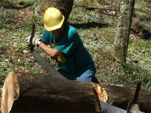
Thursday, April 23, 2009: We made a start at logging out the blowdowns on the Brush Mountain Trail today. This trail is in very bad
shape since it has been over a decade since it had any maintenance. We went in from Cold Springs Gap to the upper trailhead intersection with Cold Springs Gap Trail. We cleared 21 trees from the first 0.65 miles of this trail. A number of these trees exceeded 16” diameter, so we spent a lot of time clearing them with the crosscut saw. When we turned around there were two obvious choices for where the trail should be located up ahead. One of these was a side slope trail that had very little tread left. The other climbed straight up the fall line of the ridge at about a 40% grade, ran the ridge line, then turned down to intersect the side slope trail with another steep fall off the ridge. This latter route had old painted blazes from pre-wilderness days, so must have been the original route. We will decide on routing on the next work trip and add wilderness blazes to lead hikers in the proper direction.
Here are our volunteer hours for this work trip:
We made it through a big gap just before Ike's Peak on the Brush Mountain Trail, as the trail descended sharply towards the South Fork at that point. We had been on RR bed for a half mile or so (I found a spike in the trail and spots of coal). According to Ed's GPS we did just a little over 6 miles round trip.
Name
Travel Hours
Work Hours
Totals
Ken Jones
3
6
9
Tazz Reid
2.5
6
8.5
Ed Ley
4.5
6
10.5
Totals
10
18
28
We cut out 19 countable trees from the trail, along with the usual small stuff. Our first tree had fallen across the Charles Hall Bridge. Carey McHugh was in front driving his Jeep. Visibility was around 50 feet at best, and somehow he saw the tree blocking his lane at the end of the bridge. He and Ed radioed back to Jim and I about it, and we all stopped and cleared it. Not far out of Cold Springs Gap we found a big Cherry across the trail. It was a horse stopper, and then there was another smaller one also on Fodderstack. These 2 had fallen in the last 2 weeks. The other 16 were on Brush Mountain Trail.
The remaining work on the upper end of Brush Mountain is the confusing place in the trail that you and I had spoken about. After looking at it again today, and not being sure if you wanted to use the upper blazes or the lower or in-between, we chose to clear trees and wait till you were back to be sure and get it in the place you wanted it. All 4 of us liked the upper ridge top trail the best because after 6 inches of rain, we fell several times on the sideslope.
Apparently we made a turkey hunter mad at us too. He was in Cold Springs Gap as we came driving up, and wanted to know how we got past the gate, and where we were going. When we told him he said that was where he planned to go, but would go somewhere else. On the way out we found that someone had hung and old pair of sneakers on my trailer hitch, and not too far before we got back to the gate, a couple of trees had been dragged out into the road. One was large enough to count, but we didn't put it in the total.
Here are the volunteer hours for the work trip:
Name
Travel Hours
Work Hours
Totals
Tazz Reid
1
7
8
Jim Holland
2
7
9
Carey McHugh
1
7
8
Ed Ley
3
7
10
Totals
7
28
35
Monday, May 11, 2009: I [Ken Jones]
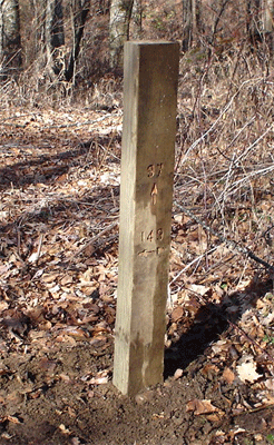
worked this past Monday routing 4” x 6” posts for placement at wilderness trail intersections. These were mostly posts that could not be placed at intersections in 2005 because the trails were being considered for decommissioning. I prepared 4 posts for placement at the following interior trail intersections:
- Brush Ridge and Cold Springs Gap Trail.
- Cold Springs Gap Trail and North Fork Citico Trail.
- Brush Ridge and South Fork Citico Trail.
- Bald River and Cowcamp Trail.
These posts are routed consistent with the other 16 posts that are already in place in wildness and wilderness study areas.
Here is my time for the day:
Travel Hours = 1.5 Work Hours = 4 Total = 5.5
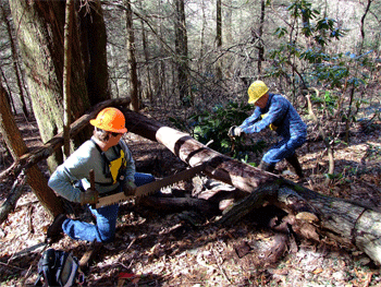
Thursday, May 14, 2009: We continued our work on clearing the Brush Mountain Trail with a large work crew. We worked again on the upper half of the trail, going in from Cold Springs Gap. We had two crosscut saw crews that cleared another 16 trees to the half way point on the trail, a gap just south of Ike’s Peak. The hiking books say that this would be 2.2 miles of trail cleared of blowdowns. We also were able to do a good job of brushing out the first mile of trail starting at the Cold Springs Gap Trail intersection.
We spent considerable time trying to determine the original trail route at one location about ¾ miles in where we found two different user marked trail routes. One trail was marked with orange ribbon and ran on the side slope for 200 yards, but had no tread at all. The other route was marked with white painted blazes, climbed 50 vertical feet on the fall line to the ridge top, and ran 200 yards on the ridge line, then dropped 40 vertical feet on the fall line to rejoin the orange flagging. Neither of these routes was marked with cut bark blazes in accordance with wilderness standards, and we could not find any old wilderness blazes in this area. There were also some other trail route choices that looked like they could have been the original route. We ended up clearing a modified route using most of the white painted blazes. We changed both ends of this route to utilize existing flat ground and take the trail off the fall line. On one end we put in two switchbacks to lessen the grade. Whether the trail is back on the original route is hard to say, but I believe that it is improved over either of the user marked routes. We placed cut bark blazes on the new route in accordance with wilderness requirements.
The end result is that the trail is much improved, but there is still a lot of work remaining to reopen the entire trail. There are still places on this upper half where even experienced hikers (that includes our own work crew) can loose the trail. Here are the hours for a hard working trail crew:
Name
Travel Hours
Work Hours
Totals
Ken Jones
3.5
7
10.5
Rick Harris
2.5
7
9.5
Jim Holland
4
7
11
Bobby Mitchell
3.5
7
10.5
Phillip Gooch
2.5
7
9.5
Tazz Reid
3
7
10
Carey McHugh
3.5
7
10.5
Ed Ley
5
7
12
Totals
27.5
56
83.5
May 20, 2009: With some great help we got two new routed sign posts installed yesterday. The first was hauled up the South Fork Citico Trail and installed at the Brush Mountain Trail intersection. We had a lot of trouble digging the hole and hit lots of big rocks in the old railroad grade. We finally were able to dig down about a foot, backfill, and then pile up rocks around the post to make it sturdy. Hopefully it will stand up to a bear pushing on the top. The second post was hauled up the Cowcamp Trail and installed at the Bald River Trail intersection. We were able to dig this hole down a little over a foot and a half, and it seemed to be sturdy after we finished. We met two hikers and one fisherman on the Bald River Trail as we worked on this post.
Here are the volunteer hours for the trip:
Name
Travel Hours
Work Hours
Totals
Ken Jones
1.5
7
8.5
Bill Hodge
1
6
7
George Wilheight
1
6
7
Totals
3.5
19
22.5
Friday, May 22, 2009: We worked again yesterday on logging out blowdowns on the Brush Mountain Trail. We went in from Warden Fields and made a wet crossing of Citico and the South Fork to get to the lower end of the trail. We had two crosscut saw crews working to clear the trail, and were able to log out 20 more trees for the day (several were in the 20” range). This work completed logging out the trail in 4 work days and a total of 73 trees.
Although the trail is now passable, it is still a challenge for even experienced route finders to follow. We put in cut bark wilderness blazes in many spots, but there are still lots of locations where you can loose the trail. In order to fix this problem, the entire trail needs to be brushed out and wilderness blazes cut in at all of the spots where the trail is indistinct.
Here are the volunteer hours for the work trip:
Name
Travel Hours
Work Hours
Totals
Ken Jones
1.5
9.5
11
Tazz Reid
1
9.5
10.5
Jim Holland
2
9.5
11.5
Carey McHugh
1.5
9.5
11
John Kalabus
2
9.5
11.5
Totals
8
47.5
55.5
Friday, May 29, 2009: We continued our work on Brush Mountain Trail yesterday. We went in from Cold Springs Gap to continue brushing out the upper section of the trail. We picked up where we had left off before, about one mile in from the upper trailhead on the Cold Springs Gap Trail. We were able to complete another mile of brush out work to the point where the trail crosses a small stream. This stream is one of the tributaries of Ike Camp Branch, and is unusual in that the stream bed consists of small grey rocks and seems to be right up on top of a mountain. We had one spot on a steep descent from a high knob where I had to cut in a number of wilderness blazes to delineate a trail route, for no route was visible. We now have the first two miles of the trail in a condition where the trail route is fairly easy to find for the average hiker.
The work accomplished for the day was 1.0 miles of trail brushed out, a couple of dozen wilderness blazes chopped in trees, and 7 miles of hiking distance covered (it is uphill both ways!). Here are our volunteer hours for the trip:
Name
Travel Hours
Work Hours
Totals
Ken Jones
1.5
9.5
11
Tazz Reid
1
9.5
10.5
Bobby Mitchell
1.5
9.5
11
Carey McHugh
1.5
9.5
11
Rick Harris
1
9.5
10.5
Totals
6.5
47.5
54
Thursday, June 11, 2009: We continued our work on brushing out the Brush Mountain Trail yesterday. We split into two crews, with a crew starting at each of the interior trailheads for the trail. Around lunch time we experienced some lightning and rain. There was already a severe thunderstorm watch in effect, so the crew on the high ridge line decided to call it a day and meet up with the crew along Ike Camp Branch. Once we met up we all headed out toward the South Fork Citico and Warden Fields. Just downstream of the mouth of the North Fork Citico, we got the really hard rain but thankfully no strong winds or lightning. The total work accomplished for the day was about another mile of trail brushed out. The upper crew got only about 0.2 miles of that total due to having to work slowly in the thick Rhododendron. For the 1.5 miles left to brush out in the middle of the trail, there is still ample opportunity for hikers to get off trail until we finish all of the work. Even after our work is done, this trail will remain a challenge to a hiker’s wilderness route finding skills.
It was especially frustrating to find that someone had pulled up the routed 4 x 6 that marked the intersection of Brush Mountain and the South Fork Citico Trails. We had just installed this marker at the best place to ford the South Fork on May 20th, so it only lasted for 3 weeks. Someone went to a lot of trouble to pull this post up, as I had nailed a short 2 x 4 at the bottom to discourage just such an action. The post was not damaged and was lying close to the hole where it was installed. I stood the post up against a tree until I can install it more permanently in the future.
Here are our volunteer hours for the work trip:
Name
Travel Hours
Work Hours
Totals
Ken Jones
1.5
6
7.5
Tazz Reid
1
6
7
Bobby Mitchell
1.5
6
7.5
Ed Ley
3
6
9
Totals
7
24
31
Friday, June 19, 2009: We began our work day by clearing a tree from Citico Creek Road between Beehouse Gap and Warden Fields. The only tools that we had were two pulaskis, but they did the job. We walked in on the South Fork Citico Trail to the intersection with the Brush Mountain Trail to re-install the routed post. Someone had pulled this post out of the ground and thrown it in the South Fork. I especially want to thank Tipi Walter for retrieving the post from the creek and putting it up on the bank. Without his help it would have been lost somewhere down stream. We were able to plant this post deeper this time since we brought in a rock bar. On our way back out we also re-installed the sign post for the North Fork Citico Trail. We were also able to plant this post deeper than it was before, so maybe it will stay put.
We next drove to the Mill Branch Trailhead to hike in and work on the big rock problem near the first Mill Branch crossing (1 mile in). We used a sledge hammer to beat the top portion of the rock down. We started busting off some large flakes, but they got smaller and harder to break off as we rounded out the top and sides of this large rock. After reducing the top portion of this rock, we stacked rocks for cribbing on the down slope side. We were then able to fill in with dirt to the point where the top of the large rock was just even with the dirt around it.
After finishing the rock work, I explored two old tram grades to see if they were usable to improve the trail. The first grade started up the left fork of Mill Branch, only to dead end about 600-700’ upstream. I walked the second tram grade about ½ mile back downstream. This grade turned out to have switchbacks that bypassed a short steep grade on the existing trail.
The heat and humidity was extreme for this work trip. When we reached the truck back at the trailhead, we were greeted by two large owls that were having a hard time sleeping in the heat of the afternoon.
Here are our volunteer hours for the work trip;
Name
Travel Hours
Work Hours
Totals
Ken Jones
1.5
7
8.5
Bobby Mitchell
1.5
7
8.5
Carey McHugh
1.5
7
8.5
Totals
4.5
21
25.5
Thursday, October 22, 2009: Brush Mountain Trail. We resumed work on the Brush Mountain Trail yesterday. We went in from Warden Fields and hiked the trail up Ike Camp Branch to the gap on the ridge line next to Ike’s Peak. After lunch we started brushing out the trail downhill and completed about a mile of clearing to tie into the previous work. There only remains about ¼ mile of trail left to brush out. We intend to make one more trip to finish the brush out work and finish cutting wilderness blazes in the confusing spots.
On the hike in we found a dead grouse lying right in the trail. It looked like it died recently from natural causes as far as we could tell. On the way out we saw two hunting dogs on the other side of the South Fork Citico. They finally made it across after one dog was swept downstream by the current.
Thank you for your and Mark’s help on this work trip. Here are the volunteer hours for the trip:
Name
Travel Hours
Work Hours
Totals
Ken Jones
1.5
9
10.5
Tazz Reid
1
9
10
Totals
2.5
18
20.5
Thursday, October 29, 2009: Brush Mountain Trail. We were able to finish maintenance work on the Brush Mountain Trail this past Thursday. We left a vehicle at Warden Fields and started in to the upper trailhead from Cold Springs Gap. We completed brushing out about ¼ mile of trail in the middle, and also did some touch up work on the rest of the upper portion of the trail. We also cut a lot of wilderness blazes to eliminate any confusing spots along the trail. The entire length of the trail is now brushed out and cleared of any blowdowns.
On the way back up to Beech Gap, Tazz’s Bronco overheated due to a leak in a lower radiator hose. He was able to fix the leak, and we certainly appreciate Mitch bringing us water to refill the radiator and get us back to the Ranger Station.
Here is the volunteer time for this work trip:
Name
Travel Hours
Work Hours
Totals
Ken Jones
1.5
9.5
11
Tazz Reid
1
9.5
10.5
Totals
2.5
19
21.5
Thursday, November 19, 2009: Brush Mtn/N Citico/Cold Spring Trails. We started the work day by changing a flat tire for a lady stranded on the Cherohala Skyway. We then used Bobby Mitchell’s mule to haul two routed posts from Beech Gap to the proper locations at the Brush Mountain Trail intersection and the North Fork Citico intersection along the Cold Springs Gap Trail. We installed the post at the North Fork but ran out of time to install the post at Brush Mountain. We will come back at a later time and plant this one in the ground. We met one backpacker on the road between Beech Gap and Cold Springs Gap. We also picked up a bag of garbage from Cold Springs Gap and hauled it out. We appreciate Bill Hodge picking up the garbage and putting it all in one spot for easy collection.
Here are our volunteer hours for this work trip:
Name
Travel Hours
Work Hours
Totals
Ken Jones
1.5
8
9.5
Bobby Mitchell
1.5
8
9.5
Totals
3
16
19
Tuesday, December 1, 2009: Brush Mountain Trail - Ken Jones went in from Cold Springs Gap today to install the post at the upper trailhead for Brush Mountain. This was the post that we had stashed near the intersection on a previous trip, but ran out of time to plant the post. After he broke through the initial small rocks near the surface, the digging was easy. It was so easy that he overshot his intended depth of 2’ by about 4”. On the way back out he turned north for a side trip on Fodderstack and took some pictures for the District Ranger.
As he approached Cold Springs Gap, he could see that there was another unmarked truck parked there with an ATV in the bed. It turns out that it was a North Carolina Wildlife Resources employee checking on the best way into Cherry Log Gap. Ken and he talked for a while and both went on their way back out the gate. Ken also spent some extra time working on various other trail administrative items. Here is Ken's time for the day:
Travel Hours = 1.5 Work Hours = 7 Total Hours = 8.5
Contact the Webmaster