
Cherokee Hiking Club
198 Crews Drive, Benton, TN 37307
Trail
Maintenance
Grassy Branch Trail
Monday, December 8, 2008
Wednesday, October 21, 2009
Wednesday,
October 5, 2011
The Grassy Branch Trail (FS Trail 91) is a 3.3 mile long trail within the Cherokee National Forest in the Tellico Ranger District which connects the Cherohala Skyway with the South Fork Citico Creek Trail (FS Trail 105). The trail is within the boundaries of the Citico Wilderness and parallels Grassy Branch and Eagle Creek into which it flows along most of its length from Grassy Gap down the drainage to where the trail intersects the much larger S Citico Creek. For much of the way the trail follows an old railroad bed used in the logging days. A good hike is to leave one car at Warden Fields along Citico Creek and then hike down Grassy Branch Trail from Grassy Gap to South Citico Creek, then down that trail another 2.2 miles to Warden Fields. There are several major creek crossings without a bridge, so plan on getting wet and avoid times of high water or cold weather. Citico Creek can be very dangerous at times of high water.
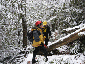
Monday, December 8, 2008: Tazz and I worked on logging out the blowdowns on the Grassy Branch Trail yesterday. We were able to complete the entire trail, clearing 21 trees with the crosscut saw. We still had a little snow on the ground up top and the stream crossings were tricky with lots of ice on the rocks. We found a lot of artifacts left over from the railroad logging days along the trail, and it is always interesting to image what the wilderness was like 100 years ago.
Here is our volunteer time for the trip:
Name
Travel Hours
Work Hours
Totals
Ken Jones
2
6
8
Tazz Reid
2
6
8
Totals
4
12
16
Wednesday, October 21, 2009: Grassy Branch Trail. We appreciate you and Mark helping us with trail maintenance today. We worked with Pam and Kent Mathews who are the trail maintainers that have adopted this trail. We were able to brush out the entire trail length. Along the way we chopped 3 trees off the trail, and these were the only ones down during the last 6 months. After our maintenance work today, I believe that the trail can be considered as Maintained to Forest Service Standards.
Here are the volunteer hours for this work trip:
Name
Travel Hours
Work Hours
Totals
Ken Jones
1.5
8.5
10
Kent Mathews
0
8.5
8.5
Pam Mathews
0
8.5
8.5
Totals
1.5
25.5
27
Wednesday, October 5, 2011 - Grassy Branch FS Trail # 91 - Citico Creek Wilderness Kent and I [Pam Mathews] brushed out the entire length of Grassy Branch Trail (2.2 miles) from the trailhead at the Cherohala Skyway parking area until the end of the trail where Eagle Branch empties into South Fork Citico Creek. We used sling blades and lopers for the first mile, then loppers and a hand saw on the lower section. We stepped over or straddled about a dozen blow downs. Although two of the blow downs were at least 12 inches, all were passable. The large blow downs were located about 1 mile from the trail head and at the end of the trail. We navigated the nine creek crossings fairly easily as the water levels were down. (Tim Homan in the Citico Creek hiking book says 8, but I counted 9). The trail is in very good condition. This is a very rich and diverse hike with lots of flora and fauna and many large trees such as cherry, beech, birch, and poplar. In fact the mid-section has the feel of an old growth forest with lots of cascading streams. There are also lots of wildflowers including many patches of Lady and Christmas ferns. We hiked the steep trek back to the Skyway, but I would recommend leaving a car at Warden Fields at Citico. One would then ford South Fork Citico Creek (easy this time of year) to connect with the South Fork Citico Creek trail (FS Trail # 105) that ends at Warden Fields.
Name
Travel Hours
Work Hours
Totals
Kent Mathews
0.5
7
7.5
Pam Mathews
0.5
7
7.5
Totals
1
14
15
Contact the Webmaster