
Cherokee Hiking Club
198 Crews Drive, Benton, TN 37307
Oswald Dome Dayhike
Saturday, February
2, 2013
Brief Description:
FS Trail 80 travels from the Picnic Area at Quinn Springs up Bean Mountain to Oswald Dome where several radio towers reside on the top of the mountain—said by one of my sources to be 2,999 feet in elevation. That being said, you basically hike from the river—around 800 feet in elevation to the summit for an elevation gain of approximately 2,200 feet. Because of this elevation gain—practically all within the first 2.7 miles—the rating is strenuous going up and moderate on the return trip. I hiked it this past weekend and it does give you a good workout.
The trail, maintained by our friends the Hiwassee Hiking Club, affords great winter-time views of the Delano area and west toward northern Bradley County, the Gee Creek Wilderness area across the river and glimpses of the mountains to the northeast. The views have been enhanced due to the last pine beetle infestation which killed many of the Virginia pines on the slopes of the mountain. The trail is in good shape and there are no stream crossings—just a few muddy places from wet weather springs.
Length: 8 miles
Difficulty Rating: Strenuous
Elevation Gain: About 2200 feet
Hike Leader: Randy Morris, 423-650-0485. Call no later than 8 p.m. Friday, February 1 for meeting places and times.
Other Useful Links:
Directions to the Trailhead:
Since the drive is short, we will get a later start than normal to allow everyone to sleep in a bit and the sun to hopefully warm up the chilly January air.
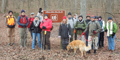
Post Trip Report: On a cold February day we had 16 hikers meet at the picnic area of Quinn Springs Campground to hike the Oswald Dome trail up Bean Mountain. This was a joint hike involving the Soddy Daisy Chapter of the Tennessee Trails Association as well as a couple of members of the Hiwassee Hiking Club. The weather really cooperated nicely as we had good winter-time views off the flank of the mountain going up to the west toward Delano and to the north looking over into the Gee Creek Wilderness Area. When we passed the area that affords good views, we experienced a cold, but pretty snow event for the rest of our trip up. On top we ate quickly as the wind was fierce, but the clouds broke again on our way down and we were treated to the spectacular views once again. 14 of the 16 hikers made it all the way up and back down the approximate 2,300 foot climb while two decided to turn back to shorten their hike. Six members and one guest from the Cherokee Club made the trip—James Anderson, Buddy Arnold, Rick and Brenda Harris (with Jake of course), guest Pam Crays (neighbor of the Harris’, Rick Foster, and hike leader Randy Morris.
Contact the Webmaster