
Cherokee Hiking Club
198 Crews Drive, Benton, TN 37307
Turtletown
Falls Dayhike
Sunday, April 29, 2012
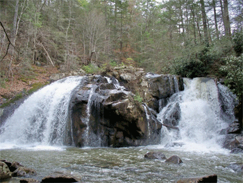
Brief Description: First mile is an easy level warm up stroll alongside the creek. Then, we'll take the left fork. It becomes a foot trail
with some hill hugging and slight elevation changes with switchbacks that take the trail down to below the twin falls . Usually, the water coming off the falls cascades dramatically down both sides of the center rock. From there, we'll continue to the second set of falls and then, hike back out on the logging road. There should be great views of the Hiwassee from the higher rises on that road while the trees are still greening up. After looping back to the left fork we took to hike in, that easy mile stroll back to our cars will be a welcome cool down.
Bring a snack and enough water. Pets are always welcome.
Length: 3.7 miles
Difficulty Rating: Moderate to Easy, but there is a fair amount of elevation gain on the return trip to the car
Elevation Gain: maybe 500 feet on the return trip to the car
Hike Leader: Marc Bernatti. Call me at 423 261-2573 if
you wish to hike so, we don’t leave you. Be advised, there is no cell phone service up here.
Directions to the Trailhead: We’ll meet at the trail head in Turtle Town Falls parking lot at 2 PM.
For those coming up Hwy 64 along the Ocoee River to Ducktown, the Hardees’ in Ocoee or in Ducktown are good meeting point to carpool. Take Hwy 68 North approximately 10 miles to the
Farner USPO on your left on Underwood Rd, look for the Flag. Then, follow the directions from that USPO.
Those coming through Tellico Plains can meet up at Hardees or up in Coker Creek at the Welcome Center/Post Office (Hwy 68, mile marker 34) to carpool. I’ll meet you there at 1:30 and we can carpool or caravan. Approximately 12 miles from the Coker Creek Welcome Center/Post Office, you'll cross a new bridge over the RR tracks. Take the second right, (on Underwood Rd at the Farner Post Office-look for the Flag).
From the Farner USPO, cross the RR tracks, bear right and turn left on Duggan Rd. Bear left onto Farner Rd. The entrance is 3/4 miles on the right. Once you enter, keep driving until you cross a wet bridge, the parking lot will be just ahead.
Post Trip Report: Three club members and Essie enjoyed a great afternoon hike alongside Turtletown Creek and above the Hiawassee River. The upper twin Falls and lower Cascades were flowing heavily from last week’s rain storm and looked spectacular.Returning on that Forestry road up along the ridge overlooking the Hiawassee got my old ticker pumping. Climbing out from the lower Cascades on that road is some elevation gain and on a warm sunny day as this was, bumps the hike to “Moderate” status. With the early greening, the views of the Hiawassee were already blocked by leaves. Overall, the trail was in good condition. The trail continuing on to the Cascades after the Twins, had a dozen or so blow downs across it. Some of those were step overs, some climb overs, a couple knee walk unders and one butt straddler. The rain that had swelled the Creek, left many wet and muddy crossings across the trail. Except for a couple of fishermen in the Creek, the trail was ours alone. Unfortunately, that FS sign up on Farner Rd that marks the entrance to the Falls, is missing. So, unless visitors knows where to turn, they would easily pass it by. Enjoying the hike were Jane Bohannon, Becky Levings, Marc Bernatti and of course, Essie. Well, after starting back up that road, maybe Essie not so much.
Contact the Webmaster