
Cherokee Hiking Club
198 Crews Drive, Benton, TN 37307
Athens
Regional Park Dayhike
Sunday, January 22,
2012
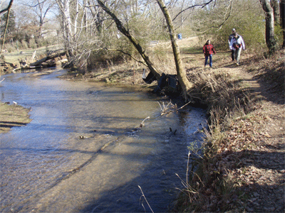
Brief Description: This trail has it’s ups and downs and scenic views in woodland, an open field, and paved area around the lake. It is a hike around the perimeter of the 165 acre park and along North Mouse Creek where beavers are sometimes seen. I am leading this hike for both the Cherokee and Hiwassee Hiking Clubs. Children accompanied by an adult and dogs on a leash are welcome. We will start at the area around the lake, then hike along North Mouse Creek, then wooded areas, and back to the trailhead. This is a nice gentle hike to get us out after the holidays and snow. THIS IS A JOINT HIKE WITH THE HIWASSEE HIKING CLUB.
Length: 3.1 miles
Difficulty Rating: Easy
Elevation Gain: Minimal, 250 feet
Hike Leader: Jane Bohannon, 745-9534 or 381-8388 (c). Please call Saturday night if you plan to attend.
Elevation Profile of the Trail
Other Useful Links: http://www.localhikes.com/Hikes/Athens_Regional_0000.asp
Directions to the Trailhead: See Google map link above. Click the Trailhead Access Map button.
From Cleveland: The park is located on Hwy 30 West (Decatur Pike). From Cleveland: Take I-75 North to first Athens Exit, then turn right onto Hwy 30 toward Athens. The park is approximately 1 mile on the right.From Etowah take Hwy 30 through Athens all the way to the park. The park is approximately 1 mile on the left from the Hwy 11(Congress Parkway) and Hwy 30(Decatur Pike) intersection.
Plan to meet at the trailhead at 2PM. The mountain bike/hiking parking lot is the first turn to the left after entering the park. This trail has its ups and downs and scenic views in woodland, an open field, and paved area around the lake. It is a hike around the perimeter of the park and along North Mouse Creek where beaver are sometimes seen.
Trail Description: This trail was created for mountain biking, but is open to hikers. We will start by hiking on a trail by the pond. Then we will hike the trail itself. What follows is our route in reverse. This description is
from a mountain biking site. The start of the trail is a short steep section with a couple of switch backs. The trail splits at the top, both ways are about the same distance and they come back together shortly. The trail the follows the ridge until it gets to a radio tower, then starts back down toward the creek. Here it splits again. You can either choose downhill (better for hikers) or Roller Coaster (great for bikers). At the bottom, you follow the creek. This is the highlight of the trail. You follow the creek all the way back close to the parking lot. This is the most scenic part. The park has restrooms. The trailhead is on the left as you enter the park. (Description from the Chattanooga Area Singletrack Alliance website)
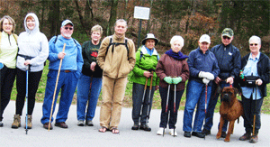
Post Trip Report: Ten club members and Percy, Marc’s Bullmastiff, hiked the 3.1 miles on this overcast afternoon with temperatures in the high fifties. Parts of the trail had been under water until today as a result of the heavy rainfall Saturday morning. We chose higher grounds to avoid gross mud in some areas. There were nice evergreens. One species of interest was Oregon Grape shrub. Richard Foster’s knowledge of plants came in handy in identifying plants such as cross vine in its winter form. We started at the lake, proceeded along North Mouse Creek, progressing to wooded areas, open fields, and back to the trail head having hiked the perimeter of the park. The only animals we saw were Angus cattle in a field on the opposite side of North Mouse Creek. Hikers were: Rebecca Levings, Richard Foster, Ann Gray, Marc Bernatti, Aggie Scott, Effaleda Lee, Robert Lee, Martha Firestone, and Boyd Firestone, and hike leader Jane Bohannon.
![]() Contact the
Webmaster
Contact the
Webmaster