
Cherokee Hiking Club
198 Crews Drive, Benton, TN 37307
Metcalf
Bottoms to Tremont Dayhike
Saturday, January 29,
2011
Brief Description: This hike will involve three trails and include a 10 mile car shuttle in the Great Smoky Mountains National Park. We will begin in the Metcalf Bottoms Picnic Area, cross the road and begin our ascent on the Curry Mountain Trail. We will gain
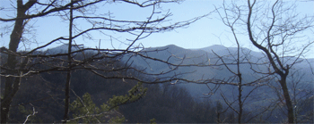
approximately 1,200 feet over the 3.3 miles of the Curry Mountain Trail and enjoy great views of Cove Mountain and later Sugarlands Mountain and Mt. LeConte in the distance if weather conditions cooperate. We will then connect with the Meigs Mountain Trail for 1.9 miles to the Lumber Ridge Trail for 4 miles—descending approximately 1,200 feet into Tremont and the other end of our shuttle. The Meigs Mountain and Lumber Ridge trails also afford some great winter-time views. We will also take a short detour to the Huskey and Ownby family cemetery along the way. Total elevation gain is about 1,500 to 1,600 feet. All stream crossings are easy rock-hops unless there have been torrential rains just before the hike. I am rating this hike as moderately strenuous to strenuous based on the climbs and length of the hike. The trails are in good shape and the ascent and descent of the ridges are long and steady. We will have dinner on the return trip in either Townsend or Maryville.
Leader: Randy Morris – Call Randy Morris at 650-0485 no later than 9 p.m. Thursday, January 27 for meeting place and times and so that final arrangements can be made. Since the drive is long, we will get a little earlier start than normal.
Difficulty: moderately strenuous
Elevation Gain: 1500-1600 feet
Length: 9.2 miles
Directions to the Trailhead: Call Randy Morris at 650-0485 no later than 9 p.m. Thursday, January 27 for meeting place and times and so that final arrangements can be made.
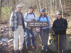
Post Trip Report: Five hikers came out on this beautiful warm crystal clear winter day. Randy Morris was not able to come because he was suddenly called down to Louisiana to work on some dysfunctional laboratory equipment. So Rick Harris and James Anderson led
the trip. We all arrived at the Tremont Visitor Center in the Smokies near Townsend at 9:30 AM, then shuttled up to Metcalf Bottoms, starting on the Curry Mtn Trail at 10:11 AM. At low elevation there was no snow, but as we neared to top of the mountain we started coming upon 3 inches or so of snow. We headed
down the Meigs Mtn Trail and stopped at an old cemetary with Ogles and other local pre-Smokies residents buried there. We also hiked by Campsite 19 which was covered with a few inches of snow. Once we got onto the south-facing slope of Timber Ridge, the snow was gone and it was like a warm spring day. The trail was in good condition except for the usual expected winter blowdowns across the trail. The views toward Thunderhead and Rocky Top (after which the song was made) were incredible along the ridgeline. We met several hikers and backpackers along the way. It seems all the backpackers were headed toward Campsite 19. They were in for a snowy and crowded experience. I don't think there is enough room for all of the backpackers we saw. We arrived at Tremont at 3:11 PM, so it took us exactly 5 hours including our cemetery stop, a few rest stops, and our lunch break. It was a beautiful day in the Smokies. Afterwards we visited "The Sinks" on the Little River and watched a kayaker go over the waterfall, then we retrieved our shuttle car up at
Metcalf Bottoms. Then we went to Townsend and ate supper at the Smoky Junction Restaurant, speaking with the owners about the unusual house within a house architecture and eating ribeyes, tilapia, and BBQ pulled pork. Hikers were Rick Harris, James Anderson, Jennifer Schroll, and Darrell and Rhonda Morgan. Since all but James were Boy Scout leaders or parents of Boy Scouts, much of the discussion centered around Scouting, High Adventure trips, Philmont, Boundary Waters, and comparing the troops. James probably got bored with all this, but for the others it was fun.
Data from GPS: 9.9 miles, Minimum Elevations 1740', Maximum Elevation 2900', Elevation Rise 1160'
Contact the Webmaster