
Cherokee Hiking Club
198 Crews Drive, Benton, TN 37307
Athens
Regional Park Dayhike
Sunday, January 31,
2010
Brief Description: This is a fairly short easy trail in the Athens Regional Park just to the east of where TN30 crosses I-75 at Athens. This trail is also used by mountain bikers.
Length: 3.1 miles
Difficulty Rating: Easy
Elevation Gain: Minimal, 250 feet
Hike Leader: Jane Bohannon, 745-9534 or 381-8388(c)
Elevation Profile of the Trail
Other Useful Links: http://www.localhikes.com/Hikes/Athens_Regional_0000.asp
Directions to the Trailhead: See Google map link above. Click the Trailhead Access Map button.
From Cleveland: take I-75 North to first Athens exit, then turn right onto Hwy 30 toward Athens. The park is approximately 1 mile on the right.
From Etowah: take Hwy 30 through Athens all the way to the park. The park is approximately 1 mile on the left from the Hwy 11 (Congress Parkway) & Hwy 30 (Decatur Pike) intersection.
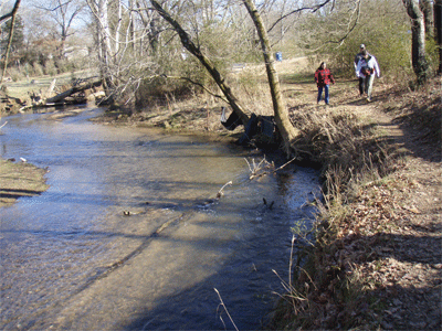
Plan to meet at the trailhead at 2PM. The mountain bike/hiking parking lot is the first turn to the left after entering the park. This trail has its ups and downs and scenic views in woodland, an open field, and paved area around the lake. It is a hike around the perimeter of the park and along North Mouse Creek where beaver are sometimes seen.Trail Description: This trail was created for mountain biking, but is open to hikers. We will start by hiking on a trail by the pond. Then we will hike the trail itself. What follows is our route in reverse. This description is
from a mountain biking site. The start of the trail is a short steep section with a couple of switch backs. The trail splits at the top, both ways are about the same distance and they come back together shortly. The trail the follows the ridge until it gets to a radio tower, then starts back down toward the creek. Here it splits again. You can either choose downhill (better for hikers) or Roller Coaster (great for bikers). At the bottom, you follow the creek. This is the highlight of the trail. You follow the creek all the way back close to the parking lot. This is the most scenic part. The park has restrooms. The trailhead is on the left as you enter the park. (Description from the Chattanooga Area Singletrack Alliance website)
Post Trip Report: It was thirty-seven degrees and sunny as we started the hike along the lake, then along North Mouse Creek, progressing to the wooded area, and back to the trailhead. It was great to be out with six dear friends after hibernating during the recent snow. There were several people at the park enjoying the melting and thawing out process with us. We walked in snow, mud, and standing water enjoying each other’s company and God’s beautiful creation. Hikers were: Effaleda and Bob Lee, Doug and Barbara Jackson, Ruth Gafford, Sheri Stewart and Sophie(Sheri’s hiker dog). ~ submitted by Jane Bohannon
In the picture above right, the hikers are from L to R: Barb Jackson, Ruth Gafford, Doug Jackson, Bob Lee, Efaleta Lee and Jane Bohannon.
![]() Contact the
Webmaster
Contact the
Webmaster