 Brief Description:
An 5 mile hike up Laurel Creek on the Cumberland Plateau to a beautiful
waterfall then back out. This is one of the pocket wildernesses on the
plateau and was the first trail in Tennessee to be designated a National
Scenic Trail.
Brief Description:
An 5 mile hike up Laurel Creek on the Cumberland Plateau to a beautiful
waterfall then back out. This is one of the pocket wildernesses on the
plateau and was the first trail in Tennessee to be designated a National
Scenic Trail.
Length:
5.0 miles
Difficulty Rating:
Moderate
Elevation Gain:
1000 feet
Hike Leader: Jane
Finch, 479-5933
Directions to the Trailhead:
Plan to meet at the commuter parking lot on 25th street at 9AM. We'll
take highway 60 into Dayton turning right onto Walnut Grove Road. Then
turn left on number 8 traffic light. You will pass La-Z-Boy factory.
Stay on that road for two miles till you come to an unmarked gravel road
with a small white church on the left. Turn right onto gravel road
proceeding about a mile to the parking area at the end of Richland Creek
Road. The hike will begin. Lunch or snack will be eaten upon arrival at
the Falls. Hope to see you there.
Old set of directions. Use whichever is
easier for you. Laurel-Snow is located north of Dayton and is
accessible via Highway 27/29. From the north turn right, and
from the south turn left, onto Walnut Grove Road north of
Dayton (new Eckerd Drug on corner). Proceed 3/4 of a mile to
Back Valley Road (pass La-Z-Boy factory) and turn left. On
Back Valley Road, proceed 0.7 miles to an unmarked gravel
road/Richland Creek Road (small white church on the left)
and turn
 right. Proceed about 1 mile to the parking area at
the end of Richland Creek Road.
right. Proceed about 1 mile to the parking area at
the end of Richland Creek Road.
Trail Description:
The hike will be approximately 5 miles and is considered
at least moderate since it involves a thousand feet or so in elevation
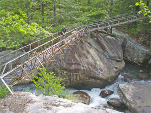
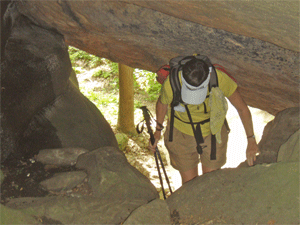
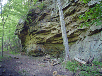
change. We will hike along Richland Creek, a beautiful creek in the Laurel-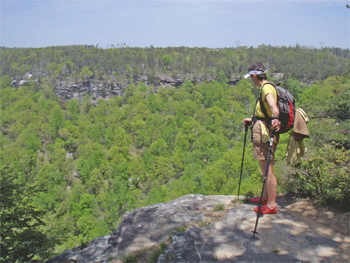 Snow Pocket
Wilderness near Dayton TN. It is one of the prettiest places I've seen
in awhile. We will hike at a moderate pace so anyone who can do the
distance and elevation change should be fine. We will see an old coal
mine, part of an old reservoir that once served Dayton, and lots of
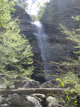
interesting rocks and cliffs. The endpoint will be a visit to
Laurel Falls, which are beautiful falls coming off the Cumberland
Plateau.
Snow Pocket
Wilderness near Dayton TN. It is one of the prettiest places I've seen
in awhile. We will hike at a moderate pace so anyone who can do the
distance and elevation change should be fine. We will see an old coal
mine, part of an old reservoir that once served Dayton, and lots of
interesting rocks and cliffs. The endpoint will be a visit to
Laurel Falls, which are beautiful falls coming off the Cumberland
Plateau.
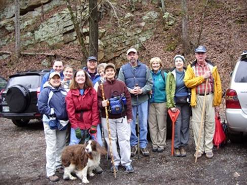
Post Trip Report:
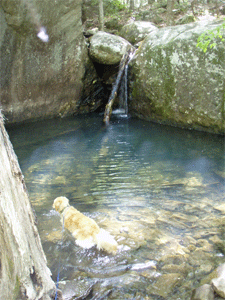
Thirteen hikers
participated in the Laurel Snow Hike. The previous day's rain caused the
waterfalls to be spectacular. Abigail, a Brittany Spaniel, lead the way
thro ugh
the rock terrain, up to the waterfall. As we viewed the falls and settled
in to eat our lunch, three
brave souls traveled further, climbing to the top of the falls, only to
inform us the view from the top was limited. As we descended down the
trail we stopped to watch kayakers maneuvering through the swift water
currents and over numerous mini falls. Hikers were: Mike and Phyllis
Callaway, David and Debbie Flowers, Will and Lindsey Smart, Kenneth
Johnson, Jane Bohannon, Peggy Griffin, Bonnie Thomas, Debbie Zuidema,
Kaye McClanahan and hike leader Jane Finch. Everyone seemed to have a
good time and expressed an interest in doing more hikes in the
Laurel-Snow Falls area, as shown in the picture below.
ugh
the rock terrain, up to the waterfall. As we viewed the falls and settled
in to eat our lunch, three
brave souls traveled further, climbing to the top of the falls, only to
inform us the view from the top was limited. As we descended down the
trail we stopped to watch kayakers maneuvering through the swift water
currents and over numerous mini falls. Hikers were: Mike and Phyllis
Callaway, David and Debbie Flowers, Will and Lindsey Smart, Kenneth
Johnson, Jane Bohannon, Peggy Griffin, Bonnie Thomas, Debbie Zuidema,
Kaye McClanahan and hike leader Jane Finch. Everyone seemed to have a
good time and expressed an interest in doing more hikes in the
Laurel-Snow Falls area, as shown in the picture below.