 Brief Description:
An 8 mile hike up Laurel Creek and
Snow Creek onto Waldens Ridge on the Cumberland Plateau to a beautiful
waterfall then back out. This is one of the pocket wildernesses on the
plateau and was the first trail in Tennessee to be designated a National
Scenic Trail.
Brief Description:
An 8 mile hike up Laurel Creek and
Snow Creek onto Waldens Ridge on the Cumberland Plateau to a beautiful
waterfall then back out. This is one of the pocket wildernesses on the
plateau and was the first trail in Tennessee to be designated a National
Scenic Trail.
Length:
8.0 miles
Difficulty Rating:
Moderate
Elevation Gain:
1000 feet
Hike Leader: James Anderson, 423-715-8824, contact him before
8PM on the Friday before
the hike.
Trail Map
Trailhead Access Map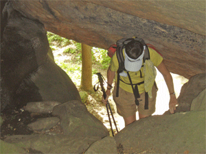
Other Useful Links: http://www.state.tn.us/environment/na/natareas/laurelsnow/
http://www.cumberlandtrail.org/laurel.html
http://www.williamson.to/Outdoors/LaurelSnow/index.html
Directions to the Trailhead:
The start time for meeting in Cleveland at 9:30AM
is a little later than usual. If enough people are interested we can
stop in Dayton for an early dinner after the hike. Also, if it is more
convenient we can arrange other meeting places besides Cleveland.
Laurel-Snow is located north of Dayton and is
accessible via Highway 27/29. From the north turn right, and
from the south turn left, onto Walnut Grove Road north of
Dayton (new Eckerd Drug on corner). Proceed 3/4 of a mile to
Back Valley Road (pass La-Z-Boy factory) and turn left. On
Back Valley Road, proceed 0.7 miles to an unmarked gravel
road/Richland Creek Road (small white church on the left)
and turn
 right. Proceed about 1 mile to the parking area at
the end of Richland Creek Road.
right. Proceed about 1 mile to the parking area at
the end of Richland Creek Road.
Trail Description:
The hike will be approximately 8 miles and is considered
at least moderate since it involves a thousand feet or so in elevation
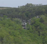
change. We will hike along Richland Creek, a beautiful creek in the Laurel-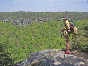 Snow Pocket
Wilderness near Dayton TN. It is one of the prettiest places I've seen
in awhile. We will hike at a moderate pace so anyone who can do the
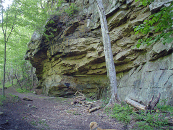
distance and elevation change should be fine. We will see an old coal
mine, part of an old reservoir that once served Dayton, and lots of
interesting rocks and cliffs. A highlight will be a stop at Buzzard's
Point where, weathering permitting, we will have a nice view of Dayton
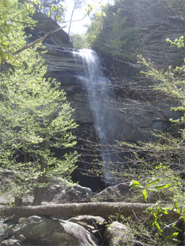
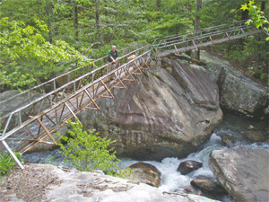
and the upper part of Lake Chickamauga. The endpoint will be a visit to
Laurel Falls, which are beautiful falls coming off the Cumberland
Plateau.
Snow Pocket
Wilderness near Dayton TN. It is one of the prettiest places I've seen
in awhile. We will hike at a moderate pace so anyone who can do the
distance and elevation change should be fine. We will see an old coal
mine, part of an old reservoir that once served Dayton, and lots of
interesting rocks and cliffs. A highlight will be a stop at Buzzard's
Point where, weathering permitting, we will have a nice view of Dayton
and the upper part of Lake Chickamauga. The endpoint will be a visit to
Laurel Falls, which are beautiful falls coming off the Cumberland
Plateau.
Post Trip Report:
With the
possibility of showers in the forecast four hikers set out on the
Laurel-Snow Pocket Wilderness hike near Dayton. The day was a bit warm and
muggy but as we neared the top of the gorge on our way to Buzzard's Point we
did pick up a bit of a breeze. Buzzard's Point is aptly named as there were
several buzzards circling round above as we ate our lunch and enjoyed the
views of Dayton and the Tennessee River to the east. One of our feathered
friends landed and even perched for awhile on a nearby rock out-cropping.
To reach the final destination of Laurel Falls we had to hike back down into
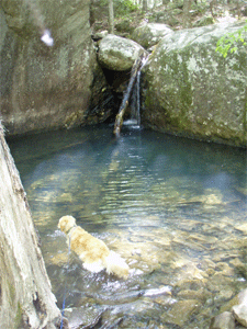
the gorge then most of the way up the other side. We saw some interesting
rock formations and potential swimming holes along the way. Also on the
hike we explored the entrance to an old coal mine and saw the pipe that used
to supply Dayton with water from a small reservoir. We rested and enjoyed
looking at and listening to the falls from the cool of a nearby shade. On
our way back to the trail head we stopped to watch some locals diving in one
of the many pools that we passed by. After the hike we enjoyed a nice
dinner at the Heartland Grill. Those participating in the hike were Evette,
Sheila, Randy and James, hike leader.
I would also like to pause for a moment to say that we are going to miss
Linda. She was an avid supporter of the club and loved the outdoors. I
know we all enjoyed hiking with her and enjoyed her company.
~submitted by James Anderson
 Contact
the Webmaster
Contact
the Webmaster