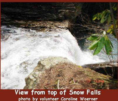
The Unicoi Crest above Tellico Plains


Cherokee Hiking Club
198 Crews Drive, Benton, TN 373
07


Laurel - Snow Pocket Wilderness Dayhike
Saturday, April 19, 2008

Laurel FallsBrief Description:   An 8 mile hike up Laurel Creek and Snow Creek onto Waldens Ridge on the Cumberland Plateau to 2 beautiful waterfalls then back out. This is one of the pocket wildernesses on the plateau and was the first trail in Tennessee to be designated a National Scenic Trail.

Length 8.0 miles

Difficulty Rating: Moderate

Elevation Gain: 1000 feet

        Hike Leader James Anderson, 423-715-8824, contact him before 9PM on the Friday before the hike.

        Trail Map

        Trailhead Access Map

        Other Useful Links:      http://www.state.tn.us/environment/na/natareas/laurelsnow/
                    http://www.cumberlandtrail.org/laurel.html
                    http://www.williamson.to/Outdoors/LaurelSnow/index.html

Directions to the Trailhead  The start time for meeting in Cleveland at 9:30AM is a little later than usual.  If enough people are interested we can stop in Dayton for an early dinner after the hike.  Also, if it is more convenient we can arrange other meeting places besides Cleveland.

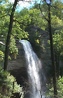
Laurel-Snow is located north of Dayton and is accessible via Highway 27/29. From the north turn right, and from the south turn left, onto Walnut Grove Road north of Dayton (new Eckerd Drug on corner). Proceed 3/4 of a mile to Back Valley Road (pass La-Z-Boy factory) and turn left. On Back Valley Road, proceed 0.7 miles to an unmarked gravel road/Richland Creek Road (small white church on the left) and turn right. Proceed about 1 mile to the parking area at the end of Richland Creek Road.

Trail Description: The hike will be approximately 8 miles and is considered at least moderate since it involves a thousand feet or so in elevation change.  We will hike along a beautiful creek in the Laurel-Snow Pocket Wilderness near Dayton TN.  It is one of the prettiest places I've seen in awhile.  We will hike at a moderate pace so anyone who can do the distance and elevation change should be fine.  We will see an old coal mine, part of an old reservoir that once served Dayton, and lots of interesting rocks and cliffs.  A highlight will be a stop at Buzzard's Point where, weathering permitting, we will have a nice view of Dayton and the upper part of Lake Chickamauga.  The endpoint will be a visit to Laurel Falls, which are beautiful falls coming off the Cumberland Plateau.

Post Trip Report: Will be posted along with pictures after the trip and this page will be moved to the "Past Activities" section of this website.

  Contact the Webmaster