
Cherokee Hiking Club
198 Crews Drive, Benton, TN 37307
Turtletown
Falls Dayhike
Sunday, March 30, 2008
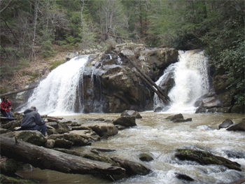
Brief Description: Turtletown Creek runs from Farner along SR68 to its junction with the Hiwassee River. Not too far from where it tumbles into the Hiwassee, there is a pair of fairly high and impressive falls
on the creek. This is our destination. The hike follows the creek downstream to the upper, then the lower falls, then takes a different route back to our cars up over a ridge on an old logging road.
Length: 3.7 miles
Difficulty Rating: Moderate to Easy, but there is a fair amount of elevation gain on the return trip to the car
Elevation Gain: maybe 500 feet on the return trip to the car
Hike Leader: Marc Bernatti
Directions to the Trailhead: We will meet at the trailhead parking lot at 2PM. Anyone going should be sure to contact Marc so no one is left behind.
Anyone coming from Etowah and points North can hook up at Hardee's in Etowah or Tellico Plains and carpool South on Hwy 68. Approximately 25 miles from Tellico Plains, there is bridge construction and traffic detours right on Waller and then left on Underwood Rd. From Underwood Rd, take Duggan Rd on the right and then take a left onto Farner Rd. The Falls entrance road is 3/4 miles on the right. Drive down the gravel road about a mile and a half to the parking lot at the end.Coming from Cleveland, the Ocoee Hardee's is a good car drop off to carpool to Ducktown and pick up Hwy 68 North. Approximately 15 miles North from Ducktown on Hwy 68, the bridge constructiondetours traffic onto Underwood Rd (Farner Post Office). After crossing the tracks, Duggan Rd will be on the left. Follow above directions.
Trail Description: The first mile is an easy level stroll alongside the creek. Then, the trail forks left. It becomes a foot trail with some hill hugging with slight elevation changes and later, switchbacks that take the trail down to below the twin falls. The falls is quite an impressive site, especially when the creek has a lot of water in it. We will then return by an old logging road up over a ridge and back down to our cars.
Post Trip Report: Club members and guests took over the Turtletown Falls Trail and parking lot Sunday afternoon. The fifteen hikers and three dogs had a great 3 hour leisurely hike on the semi loop, stopping at both waterfalls for a bite of lunch and picture taking. With all of the recent rain, water flow over the two falls (Upper Twin Falls and Lower Cascade) was strong; something not seen in that area in a while. The Sun stayed behind a heavily overcast sky making for a comfortable hike. Since the leaves are still off trees, the view of Hiawassee Gorge and River from the bluff on our return was an added bonus. In the future, I’d designate the hike as “moderately difficult.” The hillside foot trail was difficult in places and the occasional steep elevation gains, especially on the logging road up to the bluff on the return leg didn’t feel easy or moderate to me or others.
~ submitted by Marc Bernatti
Contact the Webmaster