Cherokee Hiking Club
198 Crews Drive, Benton, TN 37307
Albright
Grove Dayhike
Saturday, January
26, 2008
Brief Description: This trip is through an area of old growth in the Smoky Mountains.
Length: 7.0 miles
Difficulty Rating: Easy to Moderate, short, but with a lot of elevation gain.
Elevation Gain: 1500 feet
Hike Leader: Jim Runyan, Cell 423-744-4458, Home 423-334-1898
Other Useful Links: http://www.imagesbuilder.com/gsmnp/albright-grove-trail.html
Trailhead Access Map
Meeting Place: Bi-Lo parking lot in Etowah at 7:00 A.M. We will be leaving Bi-Lo parking lot shortly after 7:00.
Directions to the Trailhead: The trailhead is a little confusing to find. From US 441 in Gatlinburg, take US 321 15.4 miles East toward Cosby. After you pass Yogi Bears Jellystone Campground, on the right, take the first right on to Baxter Road, turn right on Laurel Springs Road, trailhead is on left at orange gate. There is a small parking area there. (Lat:35.76952 Lon:-83.26675)
Trail Description:
The Albright Grove Trail was named for Horace Albright , a conservationist and former Park Service Director. Albright Grove boasts of some of the Smokies largest virgin timber, somehow spared by the timber companies
that clearcut all the surrounding hillsides and valleys. Though it’s hard to tell now, much of the area you pass through was farmed at one time. The wide clearings around the trailhead and the homes that border the park, were the site of a Civilian Conservation Corps (CCC) camp from 1933 to 1935. They provided labor, food and shelter for thousands of men put out of work in the great depression. Its crews built many of the trails, roads, bridges and fences in the Smokies.
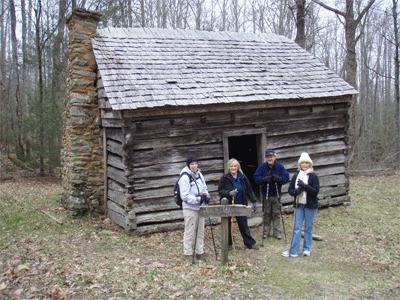
The first leg of the trail is an old jeep road still used by the Park Service, which is actually the beginning of the Maddron Bald Trail. It levels off at 0.5 miles and passes the Willis Baxter cabin, a one room cabin on the right that dates back to 1889. This cabin was made from American Chestnut, and possibly all from one tree, since American Chestnuts in this area were recorded as big as 33 feet in circumference. Some pine and poplar have been used to restore the cabin. Mr. Baxter built this cabin for his sons, two of whom set up housekeeping and started their own families here. Children slept in the loft and the cabin was surrounded by cornfields and apple trees. There is a small spring directly behind the cabin, their only source of water.
At 1.2 miles you come to the junction of 2 other trails. The Old Settlers Trail leads right 15.8 miles to
theGreenbriar section of the park and Gabe Mtn. Trail leads left about 7 miles to Cosby Campground. Maddron Bald Trail continues straight ahead through a row of boulders. The trail soon narrows and crosses over small creeks, then levels again with Eastern Hemlock on the left and mixed hardwoods on the right. The trail switches back to the right and climbs away from Maddron creek. At 2.3 miles the trail forks around an old traffic turn around. From this point on, the trail is narrower, leaving the small second-growth hardwoods and moving into bigger trees. The trail climbs a small ridge and then descends to Indian Camp Creek and crosses over a foot log. The trail then ascends and levels at the first junction with the Albright Grove Trail at 3 miles. Maddron Bald Trail bears to the left and you will continue straight ahead on the Albright Grove Trail. It makes a 0.7 mile loop through beautiful old growth timber with species including Eastern Hemlock, Yellow Buckeye, Yellow Poplar, Fraser Magnolia, Basswood and Beech. It eventually runs back into the Maddron Bald Trail. If you were to turn right, you would reach the Appalachian Trail in another 4.7 miles after intersecting the Snake Den Ridge Trail which comes in from the left. We need to turn left, however, and go about 0.3 miles back to the junction of the Albright Grove Trail where we were earlier. Turn right at the junction which leads back to our point of beginning.
Additional Trail Description: The trail starts at an old road bed with an orange gate across it, which is actually the beginning of the Maddron Bald Trail. From there it is a gradual climb all the way for 3.5 miles with a total elevation gain of about 1500 feet. However, none of the trail would be considered steep. It follows the old road for 2.3 miles then turns into a small foot path. At 3.0 miles the Albright Grove Tail turns right off the Maddron Bald Trail and makes a 0.7 mile loop back into the Maddron Bald Trail. The Albright Grove Trail is one of just a few areas of virgin timber left in the Eastern U.S. It contains some of the largest trees found in the Great Smoky Mountains with species including Eastern Hemlock, Yellow Buckeye, Yellow Poplar, Fraser Magnolia, Basswood and Beech. If you enjoy walking through big timber and listening to the babbling of small brooks, you need to make this hike. As an added bonus we may get to see a black bear or if we’re really lucky, a Red Wolf.
Post Trip Report: Six hearty hikers braved the cold temperatures to hike a 7 mile section of Albright Grove in the Cosby section of the Smokies. The trees were awesome…and HUGE!
~excerpt from email sent by Rick Harris
Contact the Webmaster