
Cherokee Hiking Club
198 Crews Drive, Benton, TN 37307
Jeffrey Hell - South Fork Citico Creek Trail
My wife and I hiked
from the top of the Jeffrey Hell Trail at West Rattlesnake Rock Parking Area on
the Cherohala Skyway down to its intersection with the South Fork Citico
Creek Trail and then out the South Fork Citico Creek Trail to its
trailhead near Warden Fields along Citico
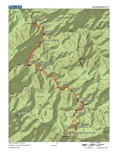 Creek Road. The hike took us
about 5 hours and was 8.6 miles long. However, we took the main trail
and the bypass trail along ford #1 and ford #2, so this added on some
distance. Thus the total distance if you take one of the other is
probably only about 8.2 miles. The bypass trail is more difficult, but
it avoids the first two crossings of Citico Creek.
Creek Road. The hike took us
about 5 hours and was 8.6 miles long. However, we took the main trail
and the bypass trail along ford #1 and ford #2, so this added on some
distance. Thus the total distance if you take one of the other is
probably only about 8.2 miles. The bypass trail is more difficult, but
it avoids the first two crossings of Citico Creek.
This is a beautiful stretch of trail, especially the lower half of the hike where the trail parallels the creek closely. There are many waterfalls and rapids. This creek is a fairly sizable creek, thus crossings may be dangerous in high water. Do not plan this trip after a heavy rainfall. Expect to get your legs wet routinely at least up to your knees. The trail for the most part follows old logging rail lines. In many places you can see old cross timbers and steel cables left from the logging days. This trail is almost entirely in wilderness, thus the trail at times may be somewhat grown over and expect a few logs across the trail.
Below are some useful files which you may want to download:
GPS Track of the trail in GPX format - right click and chose "save target as"
GPS Track of the shuttle in GPX format - right click and chose "save target as"
Waypoint file for the trip - right click and chose "save target as"
The trail follows for the most part old logging rail lines or logging roads. This area was completely logged over in the early part of the 1900's. Since then the trees have had almost 100 years to recover and many are quite sizeable. Much of the Jeffrey Hell Trail goes through rhododendron thickets. The trail got its name from a man named Jeffrey who went hunting for his lost hunting dogs in the thickets and never came back out. The trail crosses Fall Branch early in the hike. There are remnants of an old dam just upstream of the crossing which was probably used for refilling the water tanks on the Shay Locomotives used to haul the logs out of the mountains. Old steel cables are found several spots along the trail, evidence of the loggers steel cables used to move the logs down to the trains. Also the old railroad bed is places is blasted right into the side of rock cliffs. It is hard to imagine how much work was involved in making these railroad beds back in the days of more primitive heavy machinery than in use today. Just downstream of the intersection with the North Fork Citico Creek Trail on the left is an old cement buidling. This building was the magazine where explosives were stored. From here on down to the end of the trail and across the other side of the creek was the logging community known as Jeffrey. In logging days there were many homes and businesses and a large sawmill. All that is left today are a few foundations. The old community is now mostly a non-fee campground along Citico Creek called Warden Fields. Facilities are primitive. Get your water from the creek but be sure to boil or otherwise sterilize it. There is a portable privy on the site. This is though a great place to camp with a great swimming hole in the creek with a rope swing. From Warden Fields several important trails begin, including the North and South Fork Citico Creek Trails, the Pine Ridge Trail and Brush Mountain Trail.
Of note, from the West Rattlesnake Rock Pull-off on the Cherohala Skyway, not only the Jeffrey Hell Trail takes off from the left hand corner of the lot, but also the short 1.8 mile Fall Branch Falls Trail takes you to a very high beautiful waterfall. Go down the trail out of the parking lot for maybe a tenth of a mile to the wilderness sign. The Jeffrey Hell Trail goes right, and the Fall Branch Falls Trail goes left.
If you want a shorter hike than the 8.2 miles of this route, you could take the trail out of Grassy Gap (Grassy Branch Trail) down to the South Fork Citico Creek trail. This is about a 6 mile hike rather than the 8.2 of the featured hike here. And you see most of the beautiful waterfalls and rapids of the South Fork.
Access to the trails are as follows. Note that you can download a GPX track of the car shuttle, which is 11.8 miles long and takes abut 25 minutes to drive.
West Rattlesnake Rock Trailhead: Go up the Cherohala Skyway from Tellico Plains. The parking lot is well marked at about mile 22.5.
Grassy Gap Trailhead: Along the Skyway, this trailhead is near mile 20.4.
South Fork Citico Creek Trailhead: Around mile 14.3 on the Skyway, take the road toward Indian Boundary Recreation Area for about 1.3 miles. Just before entering the IBRA itself, turn right on Citico Creek Road, which quickly becomes a gravel road. Follow this road for 2.3 miles to the trailhead, just a short distance before reaching the creek and Warden Fields.